MESONET TICKER ... MESONET TICKER ... MESONET TICKER ... MESONET TICKER ...
June 1, 2015 June 1, 2015 June 1, 2015 June 1, 2015
Historic May Rains Eliminate Drought
Historic rains during May virtually eliminated the drought that had plagued
Oklahoma for much of the past five years. The storms that brought that relief
came with a cost, however, spawning more than 60 tornadoes, catastrophic flooding,
and the highest price of all, 11 fatalities. The rains began during the first
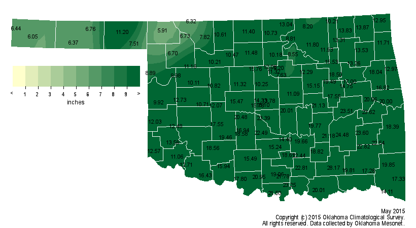
week of May and by the end of the month the state had seen the most rainfall on
record for any month in its history. The statewide average, as measured by the
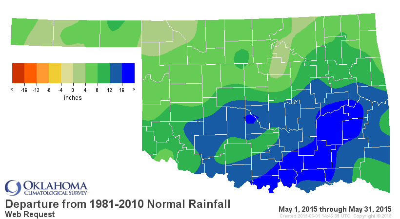
Oklahoma Mesonet, finished at 14.40 inches, 9.58 inches above normal.
http://ticker.mesonet.org/archive/20150601/may2015-rain-totals.png
http://ticker.mesonet.org/archive/20150601/may2015-rain-departure.png
That mark claims the top spot as the wettest month ever for Oklahoma, eclipsing
October 1941?s tally of 10.75 inches. Those records date back to 1895.
May 2015: 14.40"
Oct 1941: 10.75"
May 1957: 10.54"
May 1982: 10.38"
May 1943: 9.66"
Jun 2007: 9.51"
May 1902: 9.14"
Jul 1950: 9.07"
While the entire state saw much above normal rainfall, the southern half of the
state bore the brunt of the excessive moisture with widespread amounts of 15-25
inches. Many individual locations shattered marks for their wettest month on
record. The Norman Mesonet site recorded a total of 23.4 inches, obliterating
their previous high monthly mark of 16.5 inches from October 1983. Oklahoma
City claimed the same prize with 19.48 inches, besting June 1989?s 14.66 inches.
That Oklahoma City total was 14.83 inches above normal. Of the Oklahoma Mesonet
sites, Lane led the way with 28.17 inches. Twenty-two Mesonet stations recorded
at least 20 inches of rain, and 54 recorded at least 15 inches. Buffalo had the
lowest total with 5.91 inches, but even that total was more than 2 inches above
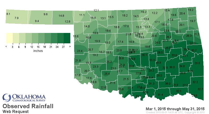
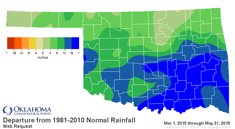
normal. Climatological spring (March-May) ended as the second wettest in state
history with a statewide average of 21.62 inches, 10.5 inches above normal.
http://ticker.mesonet.org/archive/20150601/march-may-rain-totals.png
http://ticker.mesonet.org/archive/20150601/march-may-rain-departure.png
The first five months of the year were the third wettest on record with an
average of 24 inches, 9.49 inches above normal. That's compared to 2014's
January-May total of 7.39 inches, the fourth driest on record.
http://ticker.mesonet.org/archive/20150601/jan-may-rain-totals.png
http://ticker.mesonet.org/archive/20150601/jan-may-rain-departure.png
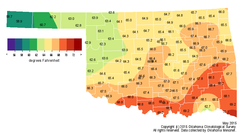
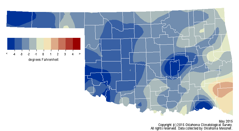
With all the rain and associated cloudiness obscuring the sun for much of the
month, it's not a surprise that May was on the cool side. The statewide average
of 65.6 degrees was 2.6 degrees below normal, the 15th coolest on record.
http://ticker.mesonet.org/archive/20150601/may2015-avg-tavg.png
http://ticker.mesonet.org/archive/20150601/may2015-tavg-depart.png
The Mesonet recorded temperatures of 90 degrees only five times during May,
with the highest being 91 degrees at Beaver and Hooker on the third and Altus
on the 18th. The average spring temperature was near normal at 59.4 degrees.
The January-May temperature remained below normal by 0.7 degrees with a
statewide average of 51 degrees, although that only ranks as the 58th coolest
on record.
Multiple bouts of flooding occurred in nearly every region of the state.
According to the Oklahoma Department of Emergency Management, 10 residents died
in May as a result of flooding. A Claremore firefighter attempting a water
rescue was one of those killed. In addition, one person died in Bryan County as
a result of a tornado. At least 49 injuries were reported due to storms during
May as well. After a record low year with 16 tornadoes during all of 2014, May
2015 saw at least 60 confirmed tornadoes by month's end according to National
Weather Service (NWS) numbers, with that number expected to rise as more
possible twisters are investigated.
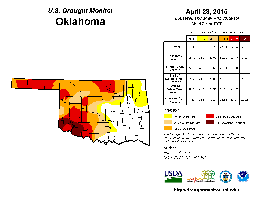
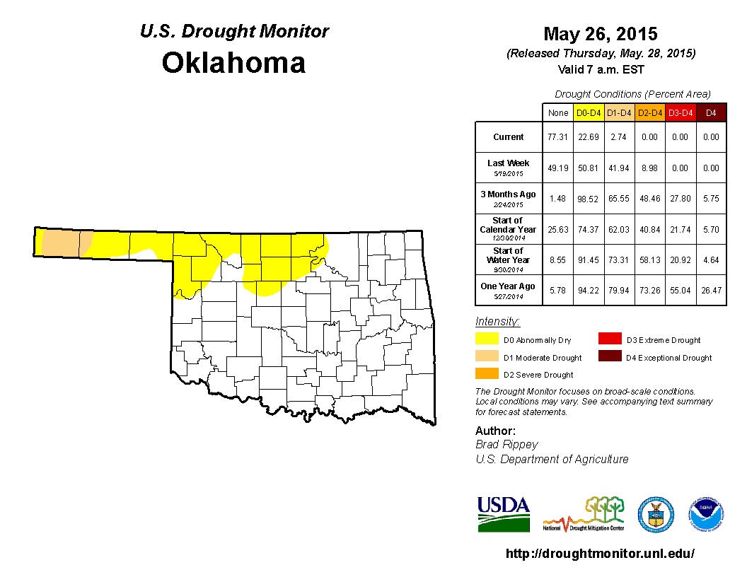
The extraordinary rains blasted the 2010-15 drought from existence, with the
only vestiges remaining across the far western Panhandle. The U.S. Drought
Monitor showed 59 percent of the state in drought at the beginning of the month,
but that area had shrunk to only 3 percent by the end of May.
http://ticker.mesonet.org/archive/20150601/apr28-drought.monitor.png
http://ticker.mesonet.org/archive/20150601/may26-drought.monitor.png
That's the lowest percentage of drought indicated for Oklahoma by the Drought
Monitor since Oct. 26, 2010, when the drought was in its beginning stages.
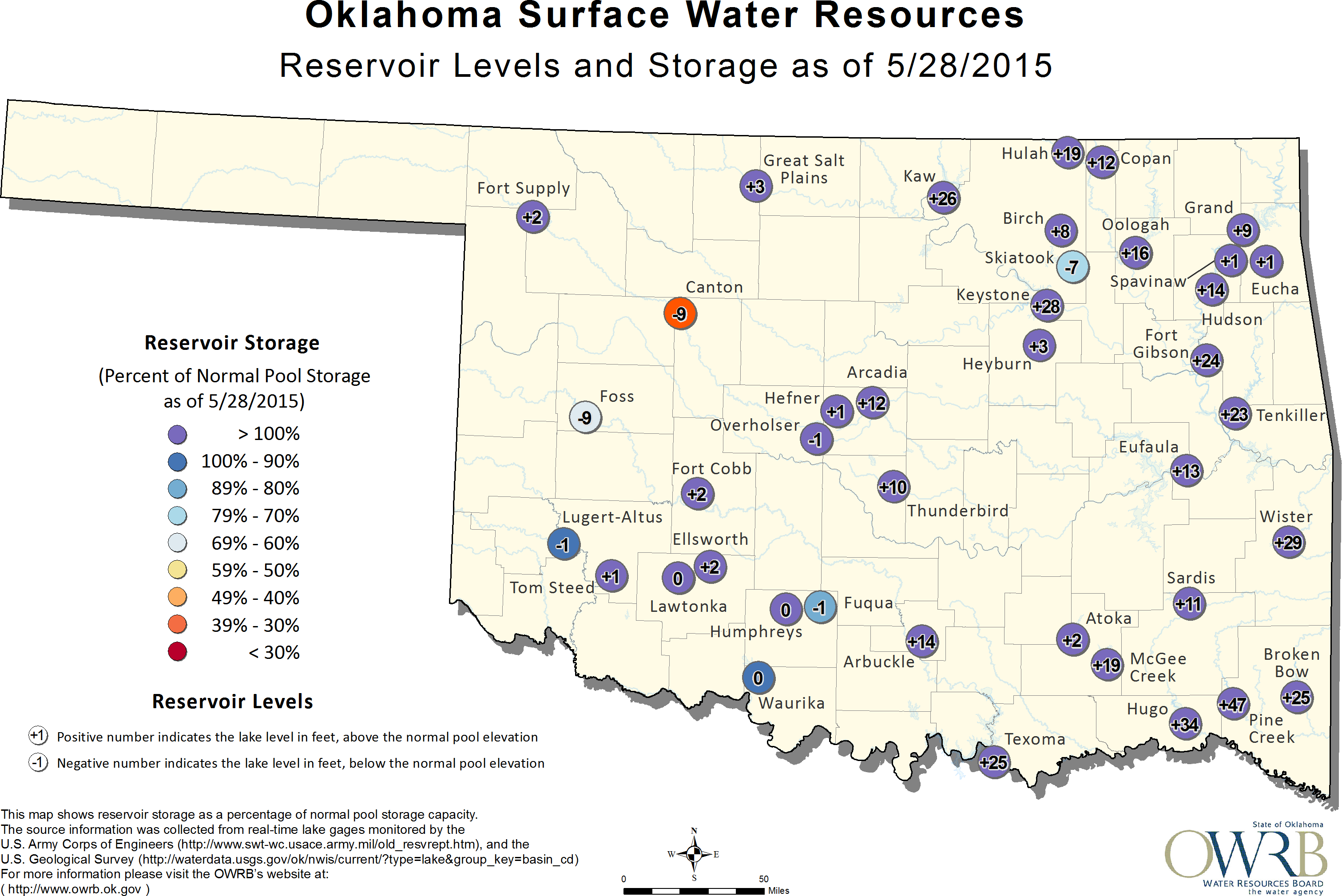
Dwindling reservoirs and dry farm ponds swelled with excess water as the
torrential rains continued to add to their coffers. Lake Tom Steed in southwest
Oklahoma, the main water supply for Altus, rose 18 feet during the month. Lake
Texoma had risen to the highest level in its history on May 29. Several lakes
still had some catching up to do, however. The reservoirs at Canton, Foss and
Skiatook remained well below normal despite the generous moisture. Canton Lake
was 9 feet below normal, or 39 percent of capacity, at the end of May.
http://ticker.mesonet.org/archive/20150601/may28-reservoir-storage.png
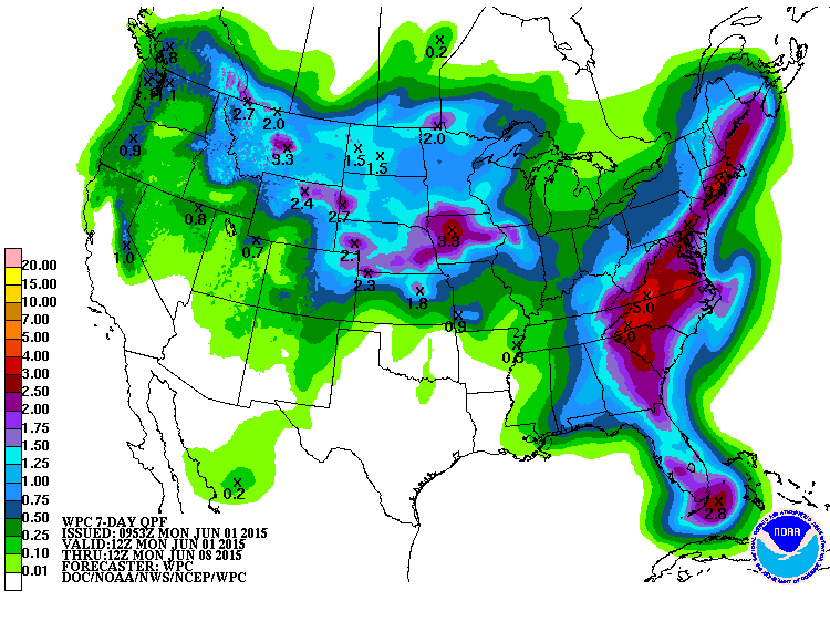
Short-term forecasts call for a relatively dry first week of June.
http://ticker.mesonet.org/archive/20150601/7day-rain-forecast.gif
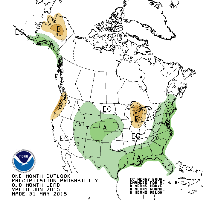
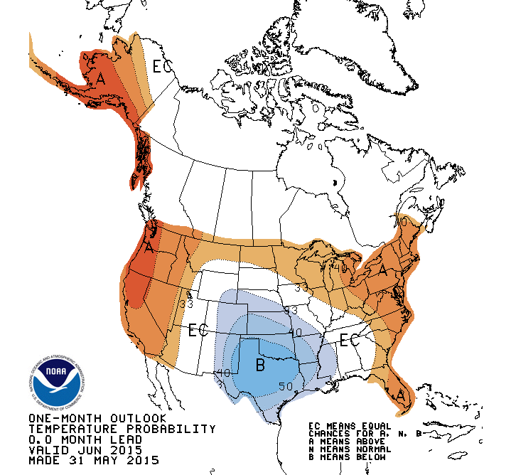
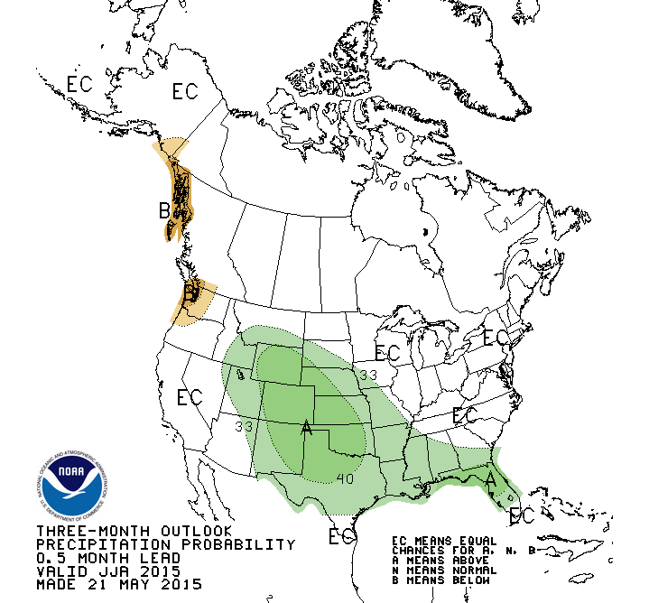
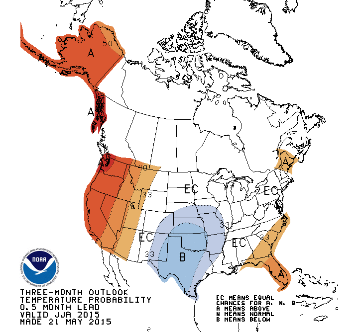
The NWS' Climate Prediction Center (CPC) show increased odds for above normal
precipitation across far western and southern Oklahoma for June and across the
entire state during the June-August period. The CPC's temperature outlooks for
both periods indicate increased odds of below normal temperatures.
http://ticker.mesonet.org/archive/20150601/june-precip-outlook.gif
http://ticker.mesonet.org/archive/20150601/june-temp-outlook.gif
http://ticker.mesonet.org/archive/20150601/june-august-precip-outlook.gif
http://ticker.mesonet.org/archive/20150601/june-august-temp-outlook.gif
CPC's Monthly Drought Outlook for June shows no signs of a return to drought
during that month.
http://ticker.mesonet.org/archive/20150601/june-drought-outlook.png
Gary McManus
State Climatologist
Oklahoma Mesonet
Oklahoma Climatological Survey
(405) 325-2253
gmcmanus@mesonet.org
==================================================
The OCS/Mesonet Ticker
https://ticker.mesonet.org/
To subscribe or unsubscribe from the Ticker
or for questions about the Ticker or its content
Phone or Email the Ticker Manager at OCS
Phone: 405-325-2253 Email: ticker@mesonet.org
---------------------------------------------------
-C- Copyright 2024 Oklahoma Climatological Survey
===================================================
|


 Tweet
Tweet