MESONET TICKER ... MESONET TICKER ... MESONET TICKER ... MESONET TICKER ...
May 28, 2020 May 28, 2020 May 28, 2020 May 28, 2020
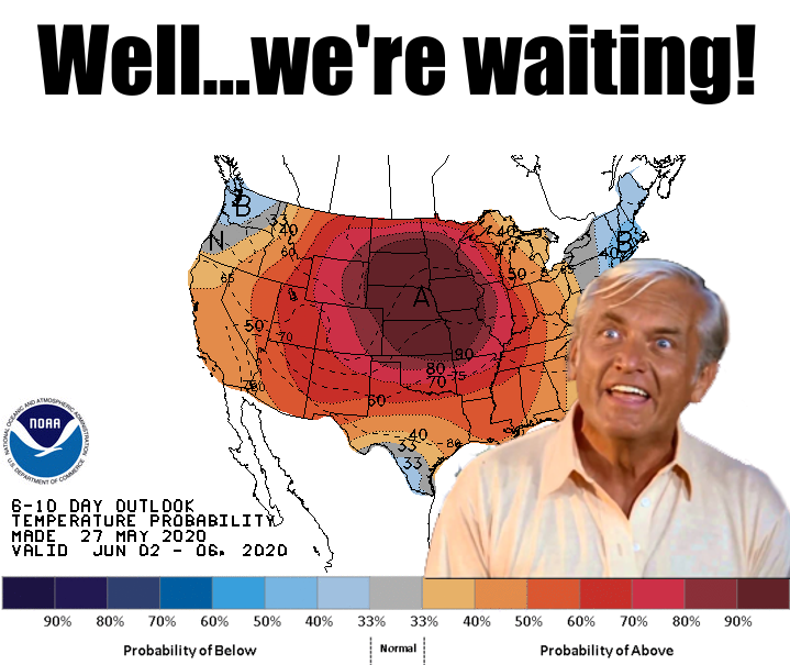
YOU'LL GET SUMMER AND LIKE IT!
http://ticker.mesonet.org/archive/20200528/june2-6-temp-outlook.png
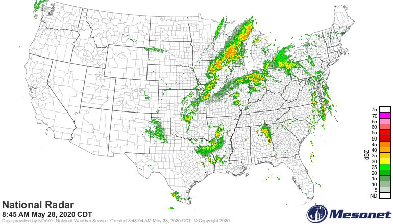
Ahh, there we go. That insane cutoff upper-level low is finally getting pushed to
the northeast out of our hair. Well, your hair, my scalp. It has been meandering
(NO, the low pressure system, not my scalp!) about the area for about a week now,
cut off from the steering winds and free to go wherever the heck it wanted. You
can see its last remnants rotating about a center across eastern Oklahoma,
bringing us one more day of intermittent showers and storms.
http://ticker.mesonet.org/archive/20200528/current-radar.png
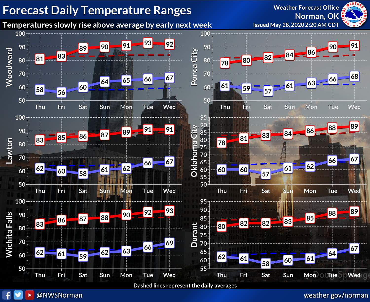
Once that shifts to the east, we will see an extended period of spring, then
late spring, and finally a bit of summer. Climatological summer, the one and
TRUE summer, begins on June 1, and it will be a bit toasty across the state;
especially out west.
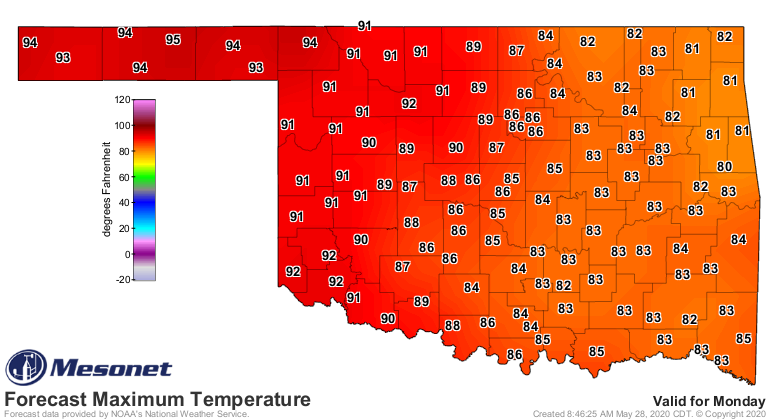
http://ticker.mesonet.org/archive/20200528/nws-norman-7day-temps.png
http://ticker.mesonet.org/archive/20200528/monday-forecast-temps.png
That warm, dry period will possibly extend even longer than that.
http://ticker.mesonet.org/archive/20200528/june2-6-precip-outlook.gif
http://ticker.mesonet.org/archive/20200528/june4-10-temp-outlook.gif
http://ticker.mesonet.org/archive/20200528/june4-10-precip-outlook.gif
It probably won't be as bad as the forecasts and outlooks make it out to be. We
won't have lots of humidity since our flow will be from the northwest, so not a
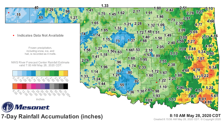
lot of return moisture making its way up from the Gulf. For the wheat farmers,
this will actually be a good thing, allowing the grain to dry out as harvesters
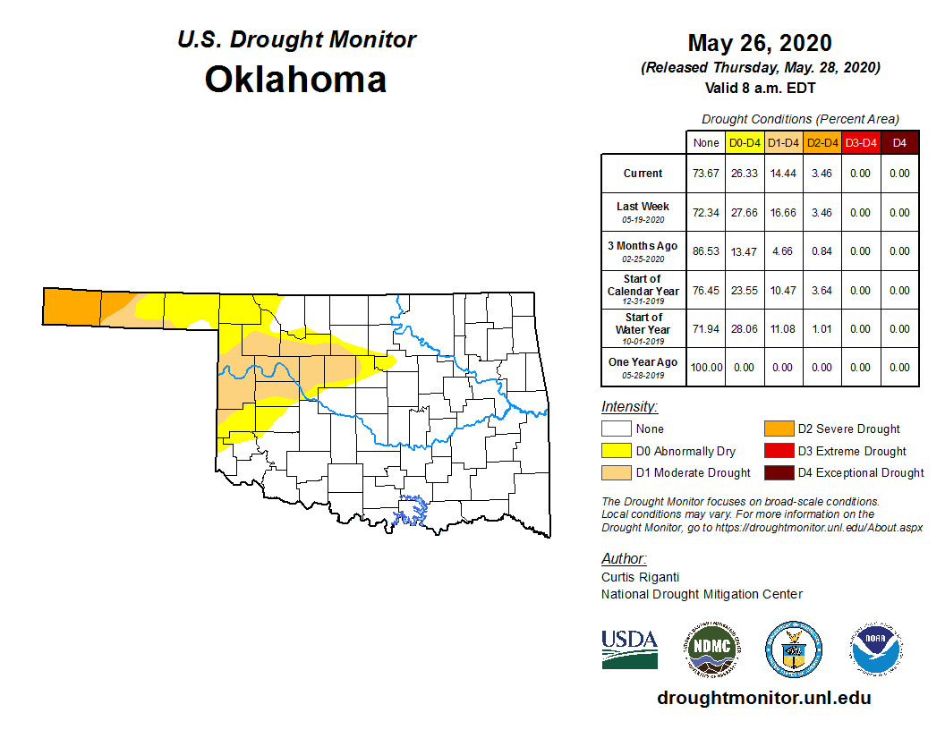
start to roll into the state. But drought conditions will greet many of those
producers after their grain is harvested, especially across northwestern
Oklahoma. This week of rains has helped alleviate some of those worries, but
it was not enough to overcome months of deficits in some places.
http://ticker.mesonet.org/archive/20200528/7day-rain-totals.png
http://ticker.mesonet.org/archive/20200528/20200526_OK_trd.png
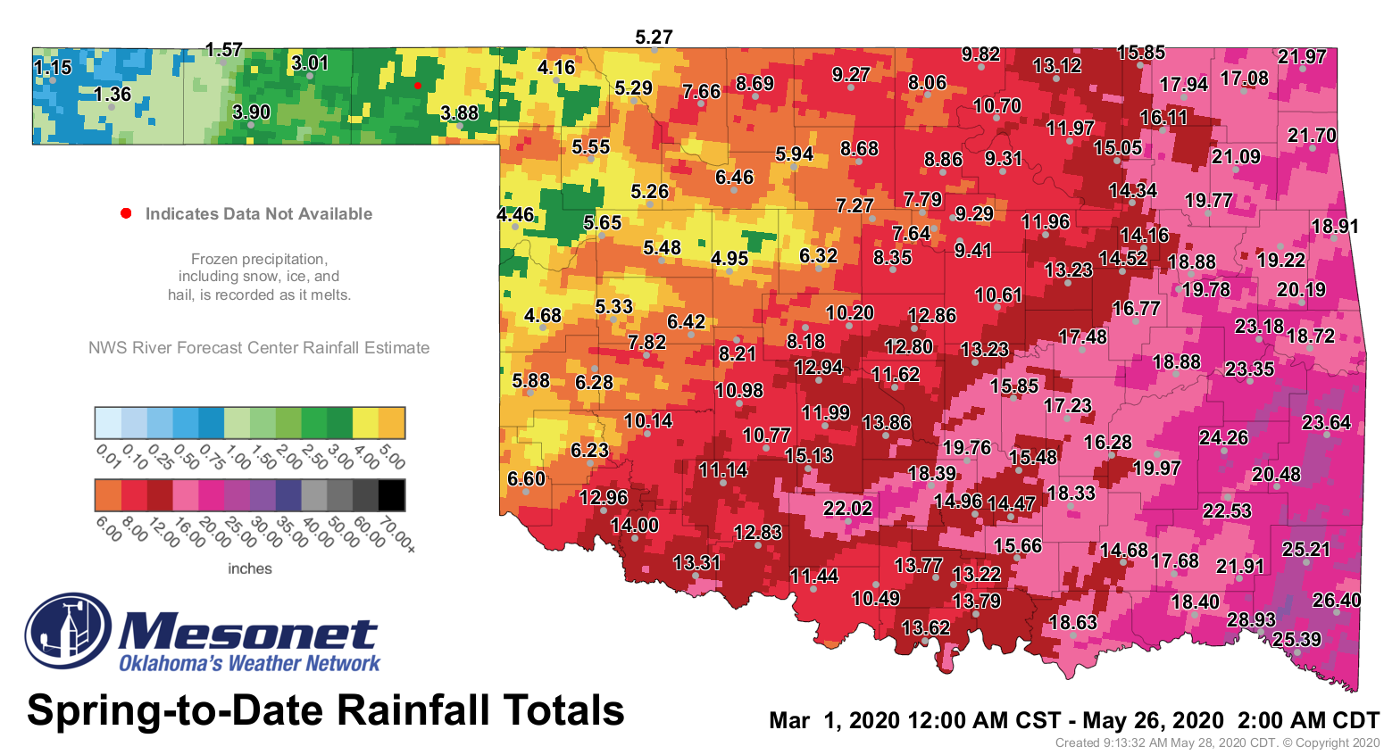
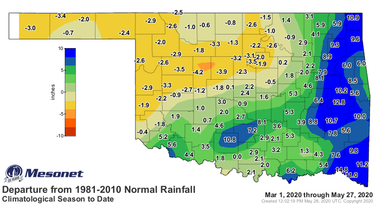
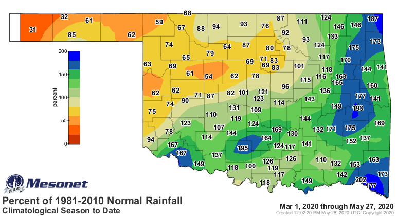
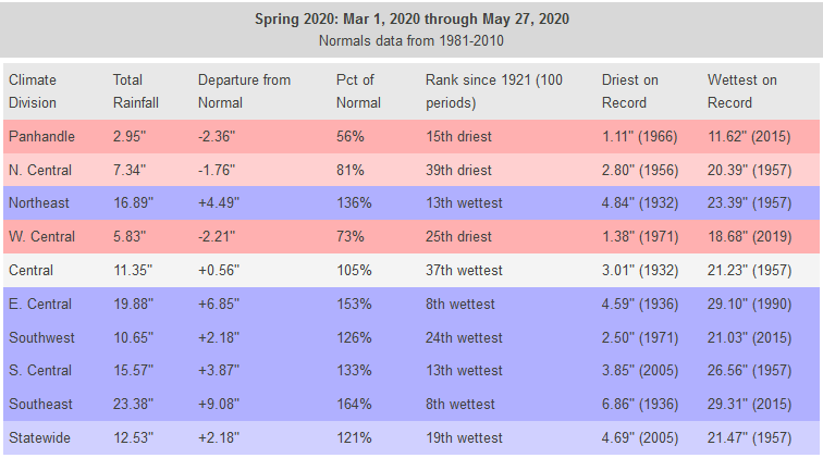
Spring rainfall is going to end up as being overly generous across most of
the state, but too stingy in the NW quarter.
http://ticker.mesonet.org/archive/20200528/spring-rain-totals.png
http://ticker.mesonet.org/archive/20200528/spring-rain-departure.png
http://ticker.mesonet.org/archive/20200528/spring-rain-pct.png
As it stands now, we're probably going to see a spring statewide average rain
total somewhere in the top 25 wettest, but the Panhandle will likely see one
in the top 20 driest. And west central's total won't be anything to write home
about either.
http://ticker.mesonet.org/archive/20200528/spring-stats.png
Despite what's needed, the upcoming week or so will be good weather to be
outside, so get out and enjoy the warmth and sunshine.
$50 says the Smails kid gets a sunburn.
Gary McManus
State Climatologist
Oklahoma Mesonet
Oklahoma Climatological Survey
(405) 325-2253
gmcmanus@mesonet.org
==================================================
The OCS/Mesonet Ticker
https://ticker.mesonet.org/
To subscribe or unsubscribe from the Ticker
or for questions about the Ticker or its content
Phone or Email the Ticker Manager at OCS
Phone: 405-325-2253 Email: ticker@mesonet.org
---------------------------------------------------
-C- Copyright 2024 Oklahoma Climatological Survey
===================================================
|


 Tweet
Tweet