MESONET TICKER ... MESONET TICKER ... MESONET TICKER ... MESONET TICKER ...
May 26, 2015 May 26, 2015 May 26, 2015 May 26, 2015
Mad May
http://ticker.mesonet.org/archive/20150526/madmay.png
Well, whenever post-apocalyptic madmen start releasing water, you know things
have gotten pretty bad. For those of you that missed the Ticker on Sunday, yes,
we have eclipsed the record for wettest May AND month for the state of Oklahoma.
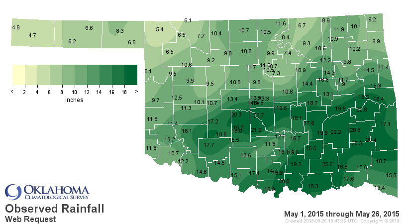
After all the shenanigans this weekend, the statewide average for the month
thus far stands at 12.93".
12.93"!!!!!!
http://ticker.mesonet.org/archive/20150526/may1-26-totals.png
http://ticker.mesonet.org/archive/20150526/may1-26-pct.png
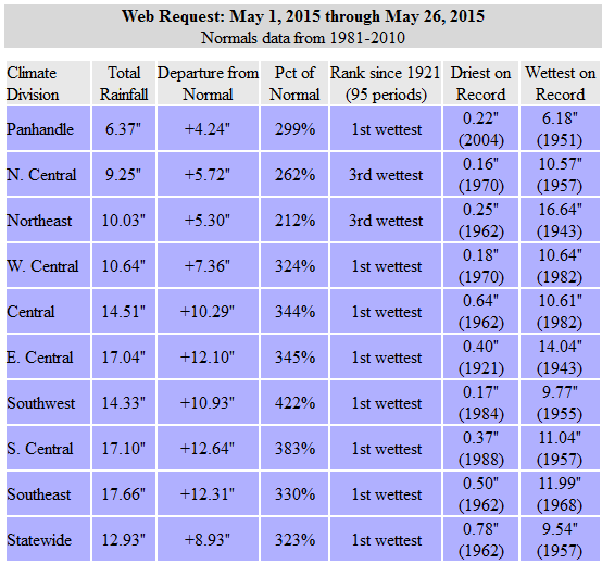
http://ticker.mesonet.org/archive/20150526/may1-26-stats.png
So our list of wettest Oklahoma months has a new sheriff in town, and we replace
that sheriff with each drop of water that falls between now and 11:59pm, May 31,
2015.
May 2015: 12.93"
Oct 1941: 10.75"
May 1957: 10.54"
May 1982: 10.38"
May 1943: 9.66"
Jun 2007: 9.51"
May 1902: 9.14"
Jul 1950: 9.07"
Again, we didn't just beat the previous record, we absolutely SMASHED it in this
"probably" El Nino-fueled enhanced southerly storm track with wide-open
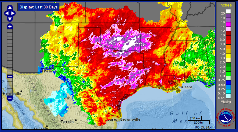
moisture flow from the Gulf of Mexico. And it's not just Oklahoma, obviously.
This type of pattern impacts the entire Southern Plains.
http://ticker.mesonet.org/archive/20150526/last30days-SP.png
The good news is that the drought, for all intents and purposes, is over for
the bulk of the state. Most lakes are full or overflowing, some to the point
of catastrophe. Speaking of catastrophe, the bad news is that widespread river
and flash flooding has wreaked havoc on lives and property over nearly all parts
of Oklahoma. According to the OK Dept. of Emergency Management, 9 storm-related
deaths have occurred since May 5, in addition to 49 injuries.
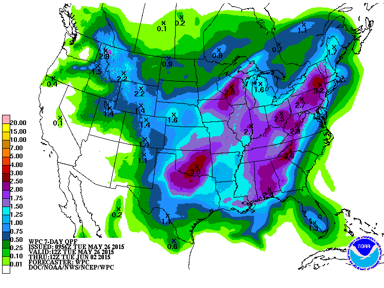
More bad news, the rain and severe weather chances are not finished. The 7-day
rainfall forecast does not bode well for those areas of the state already
underwater or filled to capacity in soils, creeks and reservoirs.
http://ticker.mesonet.org/archive/20150526/7day-rainfall-forecast.gif
In early April, we would have killed for that type of rainfall forecast. Now, in
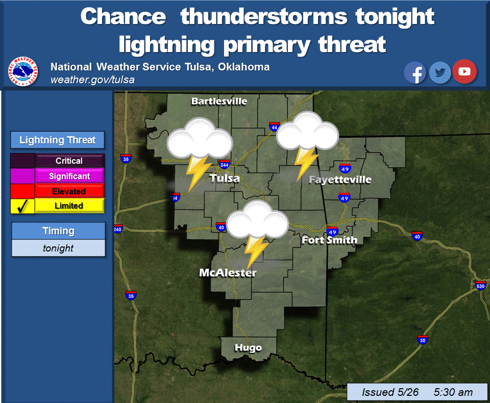
a cruel twist of fate, that type of forecast could literally kill. Severe weather
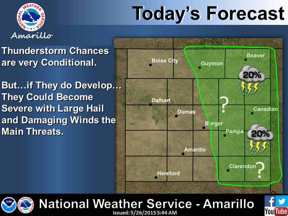
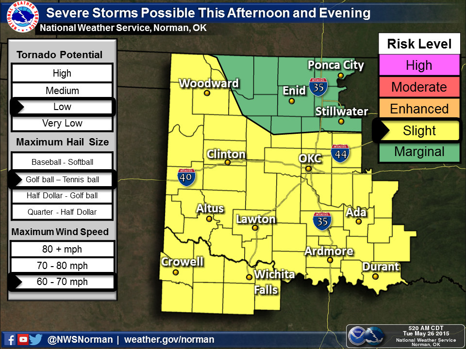
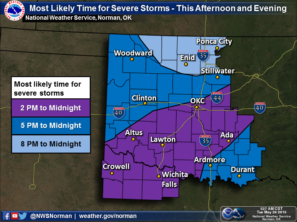
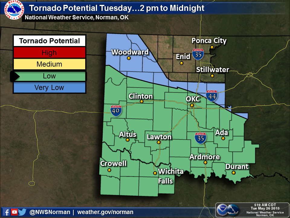
chances will go up again today. We'll let our friends at the local NWS offices
paint that picture.
http://ticker.mesonet.org/archive/20150526/nws-amarillo-svr.jpg
http://ticker.mesonet.org/archive/20150526/nws-norman-svr.jpg
http://ticker.mesonet.org/archive/20150526/nws-norman-svr-timing.jpg
http://ticker.mesonet.org/archive/20150526/nws-norman-tornado-pot.jpg
http://ticker.mesonet.org/archive/20150526/nws-tulsa-svr.png
And just in case you haven't noticed, it's been kind of chilly as well. I believe
we have probably set a few records for record low maximum temperatures over the
last several days. One of the things you'll see in a rainy month during the
warm season is a suppression of the high temperatures and little impact on the
low temperatures. The reason is pretty simple...the clouds and moisture act as
a shield to the suns rays during the daytime (hence, lower than normal high
temperatures) and a blanket at night, trapping heat that would normally radiate
away from the surface (hence, the preservation of the low temperatures). That's
exactly what we see in the Mesonet data for May thus far.
May 1-25 Statewide Average Mesonet Temperatures
Tmax Tmin Tavg
Measured 74.3 55.8 64.7
Normal 78.9 55.8 67.4
Departure -4.6 0.0 -2.7
The highest temperature we've seen on the Mesonet for May this year is 91
degrees at Altus back on the 18th. The high temperature at Woodward on the 20th
was 54 degrees, for crying out loud! That's like March, not May.
Some would say the lack of significant heat has saved us from an even worse
bout with severe weather, although the tornado numbers are stacking up. The
Norman NWS office has 32 twisters listed for May thus far, with 2 in April and
6 in March for a total of 40. Average for Jan-May is 38.4, so we're on track
to be above average thus far. That total of 40 will definitely be going up as
they investigate more damage paths.
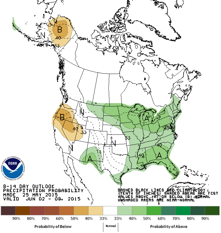
The best news I've seen is the latest CPC precipitation outlook for June 2-8.
http://ticker.mesonet.org/archive/20150526/precip-outlook-jun2-8.gif
Increased odds for normal precipitation. I'll take it.
"What a lovely day!!" that will be.
Gary McManus
State Climatologist
Oklahoma Mesonet
Oklahoma Climatological Survey
(405) 325-2253
gmcmanus@mesonet.org
==================================================
The OCS/Mesonet Ticker
https://ticker.mesonet.org/
To subscribe or unsubscribe from the Ticker
or for questions about the Ticker or its content
Phone or Email the Ticker Manager at OCS
Phone: 405-325-2253 Email: ticker@mesonet.org
---------------------------------------------------
-C- Copyright 2024 Oklahoma Climatological Survey
===================================================
|


 Tweet
Tweet