MESONET TICKER ... MESONET TICKER ... MESONET TICKER ... MESONET TICKER ...
May 19, 2014 May 19, 2014 May 19, 2014 May 19, 2014
Sauce for the (western Oklahoma) goose
Even as we pause to remember those that lost their lives, loved ones and property
in the tornado outbreak of May 19, 2013 (with an even more ominous day waiting
in the wings), we note the possible good news that those equally beleaguered and
battered folks across western Oklahoma may be about to receive.
The NWS office in Norman has a fantastic summary page of the May 19 tornadoes, by
the way. You can see that here:
http://www.srh.noaa.gov/oun/?n=events-20130519
The "beleaguered and battered" in western Oklahoma comes from a different hazard,
of course, the significant drought of the last 3.5 years which has left 30-40,
and for some localized areas, 50 inches below normal over that span.
http://ticker.mesonet.org/archive/20140519/oct1.2010-may19.2014-totals.png
http://ticker.mesonet.org/archive/20140519/oct1.2010-may19.2014-departure.png
http://ticker.mesonet.org/archive/20140519/oct1.2010-may19.2014-percent.png
-***-
Clim. Div. Total Dep. from Normal Pct of Normal Rank since 1921
Statewide 96.71" -32.43" 75% 3rd driest
Panhandle 45.34" -25.84" 64% 3rd driest
N. Central 79.60" -29.92" 73% 3rd driest
Northeast 118.54" -32.62" 78% 9th driest
W. Central 65.38" -33.12" 66% 1st driest
Central 102.12" -29.45" 78% 8th driest
E. Central 132.47" -33.18" 80% 11th driest
Southwest 71.02" -35.54" 67% 1st driest
S. Central 104.26" -41.04" 72% 1st driest
Southeast 152.44" -32.23" 83% 6th driest
-****-
The percent of normal statistic is the most telling, since it shows the amount
received relative to what would be considered normal over that time (feel free
to do Eddie Murphy's "no kidding" look from "Trading Places" when Randolph
explained how pork bellies are related to bacon and lettuce and tomato
sandwiches).
http://ticker.mesonet.org/archive/20140519/trading-places.jpg
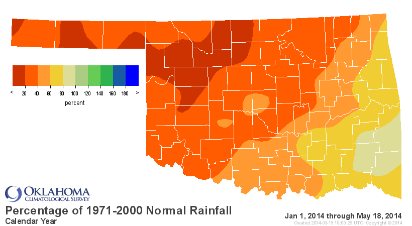
And as we've been saying ad nauseam for the last few months, the drought has
intensified once again since the beginning of the year.
http://ticker.mesonet.org/archive/20140519/caltot.png
http://ticker.mesonet.org/archive/20140519/caldel.png
http://ticker.mesonet.org/archive/20140519/calpct.png
http://ticker.mesonet.org/archive/20140519/cal-stats-table.png
What we've been missing for western Oklahoma throughout this year (and heck,
most of the time throughout the 3.5 year drought period) are those slow-moving
upper-level storms that sit out west across the four-corners region and just
pump moisture up into the higher elevations of the High Plains. Instead, we've
been getting a lot of either dry storm systems, or the systems we've seen
this spring that move through so fast the storms don't initiate until well east
of the area. Now, you asked for a miracle, I give you the F...B...I. Whoops,
a bit of Hans Gruber there. You ask for a miracle, I give you a cutoff upper-
level low that will do exactly as needed (we hope) and sit out across the four-
corners region and really pump up the southerly winds for a few days, eventually
getting copious amounts of Gulf moisture back into the western areas of OK, TX,
KS and eastern areas of NM and CO. Then that upper-level low will send out
impulses of disturbed weather that will provide opportunities for rainfall
from about Wednesday through the weekend into early next week. How much, you
say?
Check out this lovely, beautiful MAGNIFICENT 7-day rainfall forecast from WPC.
http://ticker.mesonet.org/archive/20140519/7day-rain-forecast.gif
3-4 inches across western Oklahoma and the Panhandle??? Are you kidding me?
In the past, those 7-day rainfall forecasts did end up being jokes, but this one
is a bit different. We haven't had one of those slow-moving systems like this
in quite some time. It certainly has the NWS forecasters out in Amarillo that
cover our Panhandle excited.
"WITH THE INCREASE OF ATMOSPHERIC MOISTURE TOWARD THE END OF THIS
WEEK...PRECIPITABLE WATER VALUES WILL INCREASE TO BETWEEN 1.0 AND 1.5
INCHES ACROSS THE PANHANDLES. THESE VALUES ARE ABOVE THE 75TH
PERCENTILE FOR THIS TIME OF YEAR...INCREASING THE LIKELIHOOD FOR
EFFICIENT HEAVY RAIN PRODUCING STORMS. STORM MOTIONS WILL BE SLOW DUE
TO WEAK STEERING FLOW ESPECIALLY BEFORE THE WEEKEND...INCREASING THE
CHANCES FOR THESE STORMS TO PRODUCE FLASH FLOODING. ALSO...THE
SEVERAL DAYS OF POSSIBLE RAINFALL MEAN SOME RAIN WILL FALL ON ALREADY
WET SOILS BEFORE THE WEEKEND IS OVER. THE POTENTIAL FOR FLASH
FLOODING WILL NEED TO BE MONITORED AS THIS EVENT EVOLVES."
That's one of the keys for any heavy rains that might occur both in the
Panhandle and the far western areas of the state. The ground is so devoid of
moisture that it has been baked hard by the sun the last few months. As we saw
with the big rains back in September, a lot of that water fell so quickly that
it ran right off into the streambeds and was never allowed to soak into the
soil. As an example, take a look at the 7-day rainfall map from the Mesonet
back on September 17. See the 5"+ rains out in Cimarron County that actually
caused the Beaver River to have some very rare flows in it?
http://ticker.mesonet.org/archive/20130917/7day-totals.png
http://ticker.mesonet.org/archive/20130919/beaver-river.jpg
So this is definitely much-needed moisture. As for how it affects the short-
and long-term drought impacts, we'll just have to wait and see on that. And the
other good news is that even after the 7-day period, it appears like the
chances for continued wet weather might continue.
And, also per usual for a storm like this, things will get worse before they
get better. With the strong dry south-southwesterly winds and the drought
conditions, we're primed for more fires. That's why the NWS has issued fire
weather watches and red flag warnings across the entire area.
http://ticker.mesonet.org/archive/20140519/nws-advisory-map.png
http://ticker.mesonet.org/archive/20140519/nws-ama-fire1.jpg
http://ticker.mesonet.org/archive/20140519/nws-ama-fire2.jpg
http://ticker.mesonet.org/archive/20140519/nws-norman-fire1.jpg
http://ticker.mesonet.org/archive/20140519/nws-norman-fire2.jpg
http://ticker.mesonet.org/archive/20140519/nws-norman-fire3.jpg
http://ticker.mesonet.org/archive/20140519/nws-tulsa-fire.png
And the best news of all, *AT THIS TIME* this doesn't look to have the proper
ingredients for a bigtime severe weather event (i.e., no tornado outbreak). It
is May in Oklahoma, and anything can happen, so as usual stay tuned to your
favorite forecast provider as we approach mid-week in case things change.
So you have to eat out instead of BBQ for Memorial Day. That's okay. With the
Governor's burn ban, you're not supposed to be BBQ'ing anyway!
Gary McManus
State Climatologist
Oklahoma Mesonet
Oklahoma Climatological Survey
(405) 325-2253
gmcmanus@mesonet.org
==================================================
The OCS/Mesonet Ticker
https://ticker.mesonet.org/
To subscribe or unsubscribe from the Ticker
or for questions about the Ticker or its content
Phone or Email the Ticker Manager at OCS
Phone: 405-325-2253 Email: ticker@mesonet.org
---------------------------------------------------
-C- Copyright 2024 Oklahoma Climatological Survey
===================================================
|


 Tweet
Tweet