MESONET TICKER ... MESONET TICKER ... MESONET TICKER ... MESONET TICKER ...
May 7, 2015 May 7, 2015 May 7, 2015 May 7, 2015
I'll ask again...
Have ya had enough? After spending the better part of last night in the fraidy
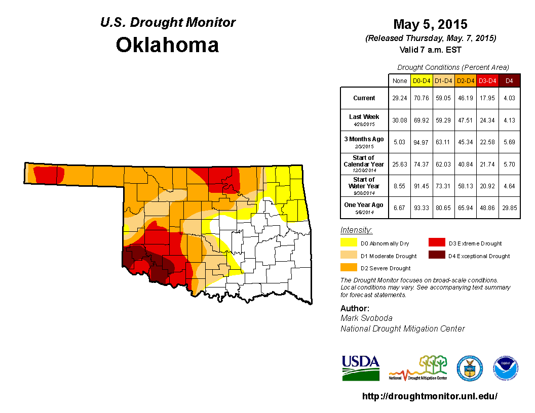
hold, I certainly have. However, we are seeing great drought relief, so let's
dispense with the formalities and show you the great shrinking U.S. Drought
Monitor map. Well, the drought is shrinking, not the map.
http://ticker.mesonet.org/archive/20150507/20150505_OK_trd.png
Now remember, that's using rainfall up through Tuesday morning, so the torrents
of the last couple of days won't count until next week. I think it's obvious we'll
see a lot of drought disappear from central Oklahoma.
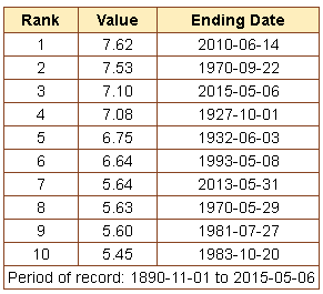
Yesterday's rainfall was rather historic in central Oklahoma. The 7.1 inches
recorded at Will Rogers in Oklahoma City was the third highest total on record
for ANY day at the official OKC observing station, dating back to 1891 or so.
Here are the top 10.
http://ticker.mesonet.org/archive/20150507/top10-okc-rains.png
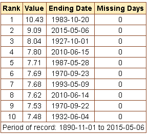
The 2-day total of of 9.09 inches is the 2nd highest on record.
http://ticker.mesonet.org/archive/20150507/top10-okc-2day-rains.png
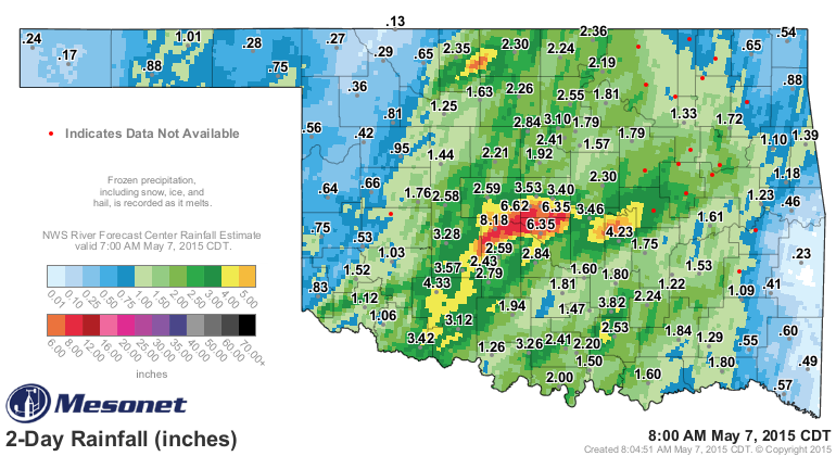
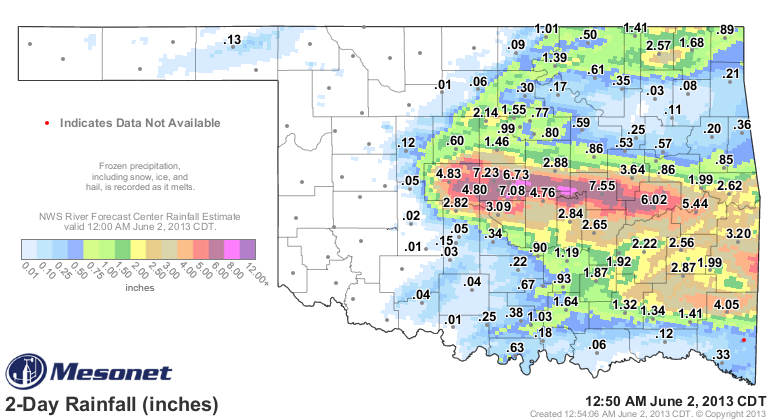
If you look at the Mesonet rainfall maps with the radar-gauge estimated overlay,
you can see just how that hurricane-like storm just churned away dropping
tornadoes and lakefulls of rain.
http://ticker.mesonet.org/archive/20150507/rainrfc.48hr.png
Lots of 4-8 inch rain amounts both on the gauges in central Oklahoma and also
radar indicated, but there are a few areas that probably went even higher, from
8 inches to as much as 12 inches. Thus, the massive amount of flooding across
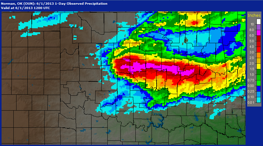
central Oklahoma. This is very reminiscent of other periods of flooding in
central Oklahoma we've seen, from May 31, 2013 (the El Reno massive tornado day)
http://ticker.mesonet.org/archive/20150507/may31-2013-rainfall.png
***
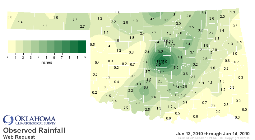
To the June 13-14, 2010, event:
http://ticker.mesonet.org/archive/20150507/june13-14-2010-totals.png
http://ticker.mesonet.org/archive/20150507/radar-estimates-june14-2010.png
NWS Norman has a nice writeup on that event, with rainfall totals of more than
12 inches in at least one case.
http://www.srh.noaa.gov/oun/?n=events-20100614
PUBLIC INFORMATION STATEMENT
NATIONAL WEATHER SERVICE NORMAN OK
1245 PM CDT TUE JUN 15 2010
...SELECTED RAINFALL TOTALS OF 5 INCHES OR MORE...
AMOUNT SOURCE APPROXIMATE LOCATION
/INCHES/
..OKLAHOMA COUNTY..
12.31 COCORAHS BRYANT AVE AND E 15TH IN EDMOND
11.85 SPOTTER AIR DEPOT BLVD AND HEFNER ROAD
11.47 MESONET BROADWAY EXTENSION AND WILSHIRE BLVD
10.73 COOP OB BRYANT AVE AND EDMOND ROAD
9.55 COCORAHS CLASSEN BLVD AND NW 48TH STREET
9.36 MESONET INTERSTATE 35 AND NE 4TH STREET
9.00 SPOTTER MACARTHUR AVE AND WILSHIRE BLVD
8.83 COCORAHS COUNCIL ROAD AND SW 44TH STREET
8.80 COCORAHS WESTERN AVE AND NW 150TH STREET
8.74 MESONET PORTLAND AVE AND NW 3RD STREET
8.59 COOP OB ARCADIA LAKE
8.47 COCORAHS MACARTHUR BLVD AND NW 50TH STREET
8.40 COCORAHS PENNSYLVANIA AVE AND SORGHUM MILL ROAD
8.06 SPOTTER MERIDIAN AVE AND NW 164TH STREET
7.91 COCORAHS MACARTHUR BLVD AND BRITTON ROAD
7.86 COCORAHS COUNCIL ROAD AND NW 23RD STREET
7.80 NWS OB WILL ROGERS WORLD AIRPORT
7.25 NWS OB WILEY POST AIRPORT
7.23 MESONET WESTMINSTER ROAD AND NE 63RD STREET
5.19 SPOTTER MACARTHUR BLVD AND NORTHWEST EXPRESSWAY
..LOGAN COUNTY..
10.09 COCORAHS MIDWEST BLVD AND WATERLOO
7.60 COCORAHS 5 SSE GUTHRIE
7.31 COCORAHS KELLEY AVE AND WATERLOO
6.59 COOP OB 4.5 SSE GUTHRIE
6.36 COCORAHS 2 S GUTHRIE
5.52 MESONET 4 WSW GUTHRIE
..CANADIAN COUNTY..
6.90 COCORAHS MUSTANG ROAD AND SW 74TH STREET
6.78 COCORAHS CEMETERY ROAD AND SW 59TH STREET
..PAYNE COUNTY..
5.89 COOP OB CUSHING
5.08 MESONET 5 E ORLANDO (LAKE CARL BLACKWELL)
..POTTAWATOMIE COUNTY..
5.58 COCORAHS 0.5 ESE TECUMSEH
5.34 COCORAHS 1 ESE SHAWNEE
5.34 MESONET 3 NNW SHAWNEE
5.27 COCORAHS 2 ENE SHAWNEE
***
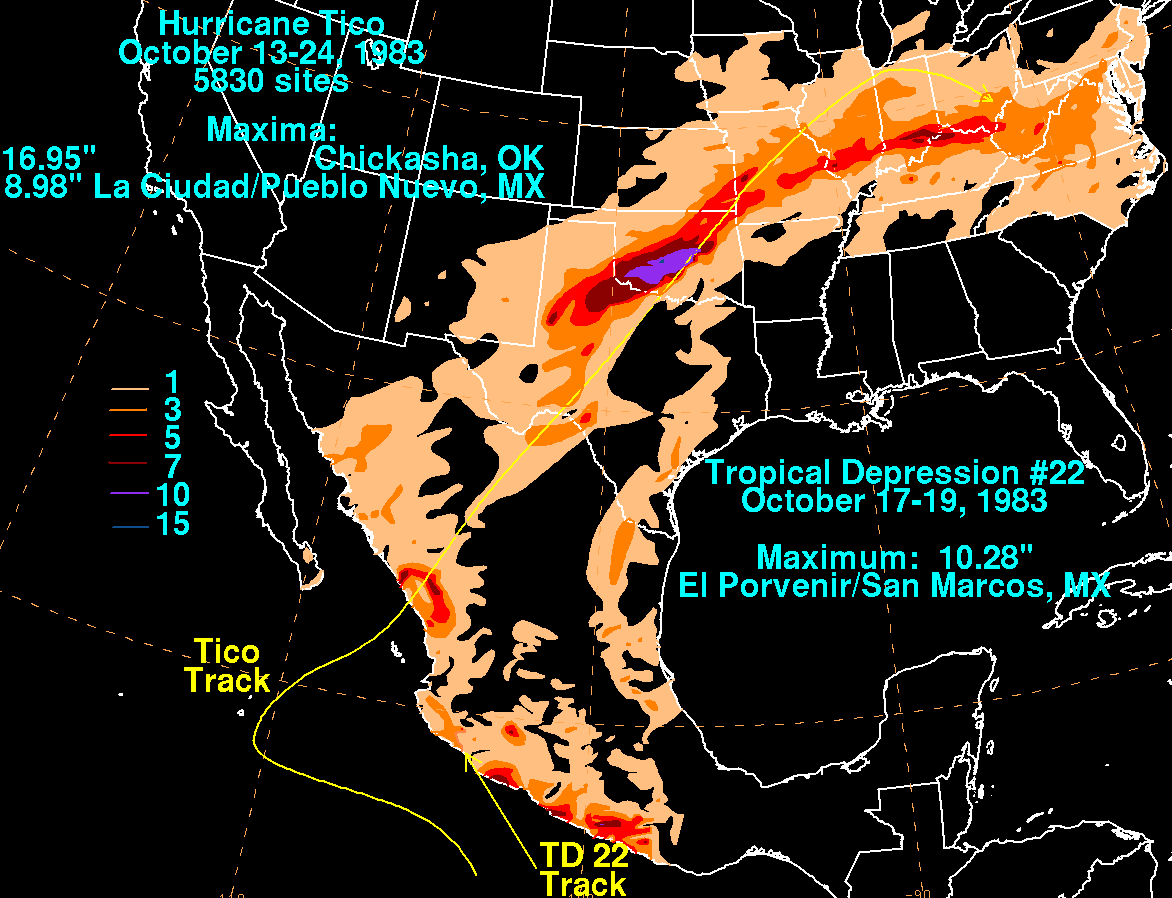
And all the way back to the Hurricane Tico floods of October 1983.
http://ticker.mesonet.org/archive/20150507/hurricane-tico-totals.gif
You can read an account of the Tico floods written by former OK Associate
State Climatologist (and Ticker Grand Poobah) Deke Arndt in our Fall 2008
Seasonal Summary:
http://climate.ok.gov/summaries/seasonal/Oklahoma_Climate_Fall_2008.pdf
***
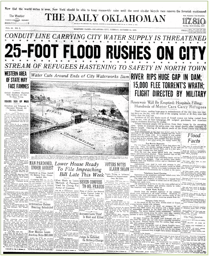
And while it was due more to big rains to the NW and W of OKC, who can forget
the floods of October 1923, with a wall of water 25 feet high coming down
the river and overtopping the Overholser dam (also detailed in another issue
of our seasonal summary):
http://climate.ok.gov/summaries/seasonal/Oklahoma_Climate_Summer_2008.pdf
Check out the Daily Oklahoman headlines from back then...sound fun?
http://ticker.mesonet.org/archive/20150507/oct16-1923-oklahoma.png
Yeah, you read it right..."Western Area of State May Face Famines." A much
different time, eh?
***
So it's hard to say what's the worst flood. Each have their own distinctive
stories with differing timelines and such. The good news is that last night's
floods didn't appear to claim any lives. In fact, I haven't heard of any deaths
yet from last night's weather, but I'm just perusing preliminary data.
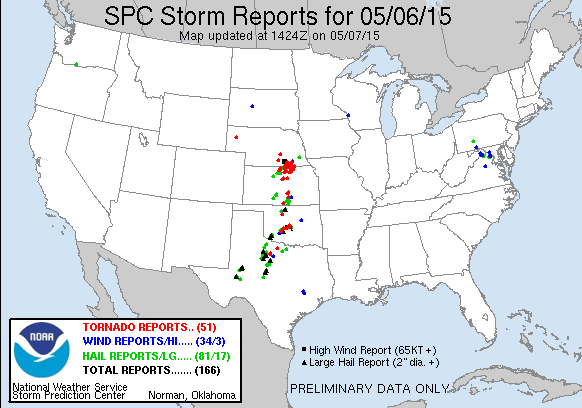
Speaking of preliminary data, it appears about a dozen tornadoes touched down
yesterday, along with a ton of large hail and high wind reports (and flash/river
flooding!).
http://ticker.mesonet.org/archive/20150507/yesterday-storm-reports.gif
Watch for info from your local NWS offices for more up-to-date info. And more
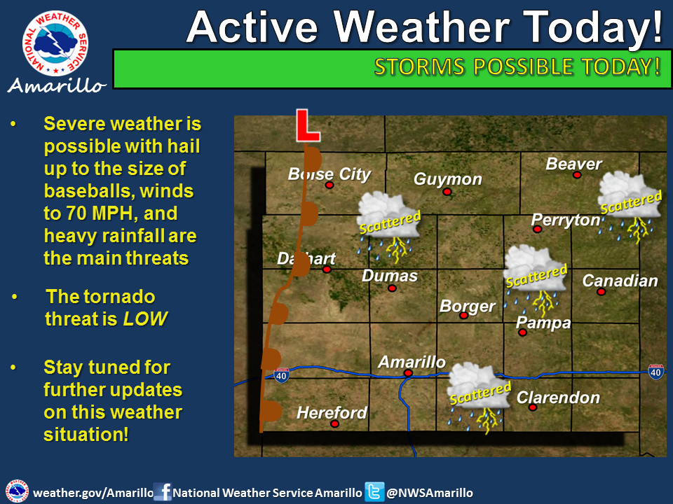
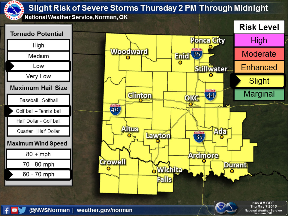
bad news, it looks like we'll be doing something similar for the next few days.
The chances for severe weather will continue as long as that big upper-level
low and dryline are out to our west, with some of the severe weather forecasters
I listen to saying that Saturday looks "very interesting." Ominous!
http://ticker.mesonet.org/archive/20150507/nws-amarillo-svr.jpg
http://ticker.mesonet.org/archive/20150507/nws-norman-thur-svr.jpg
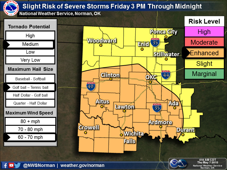
http://ticker.mesonet.org/archive/20150507/nws-norman-fri-svr.jpg
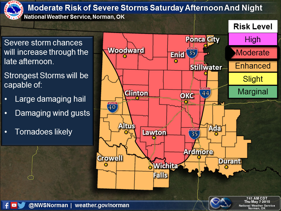
http://ticker.mesonet.org/archive/20150507/nws-norman-sat-svr.jpg
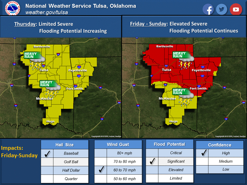
http://ticker.mesonet.org/archive/20150507/nws-tulsa-svr.png
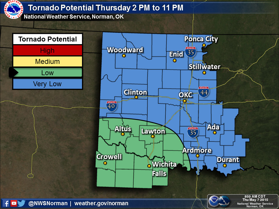
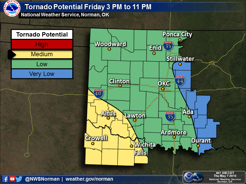
Here is some info on the tornado potential for the NWS Norman forecast area:
http://ticker.mesonet.org/archive/20150507/tornado-potential-thur.jpg
http://ticker.mesonet.org/archive/20150507/tornado-potential-fri.jpg
Again, I'll just re-post the Saturday image. To see a moderate risk on Day 3
is a bit worrisome. But at least we won't be dealing with any schooltime issues
this time.
http://ticker.mesonet.org/archive/20150507/nws-norman-sat-svr.jpg
Notice that graphic says "Tornadoes likely." BOO HISS!!
To quote the Storm Prediction Center for Saturday:
"BY LATE SATURDAY AFTERNOON...THE INGREDIENTS SHOULD COME TOGETHER TO
SUPPORT A SEVERE WEATHER OUTBREAK ACROSS THE SRN/CENTRAL PLAINS.
ALTHOUGH THERE REMAIN UNKNOWN DETAILS WITH RESPECT TO MOST
SIGNIFICANT THREAT AND STORM EVOLUTION...GENERAL PATTERN RECOGNITION
AND REMARKABLE AGREEMENT IN LATEST GUIDANCE ... ALL
SUPPORT A RELATIVELY HIGH CONFIDENCE FORECAST OF NUMEROUS INTENSE
STORMS/SUPERCELLS CAPABLE OF PRODUCING VERY LARGE/DAMAGING HAIL AND
A FEW STRONG/LONGER-LIVED TORNADOES IN THE MODERATE RISK AREA."
Let those maps be your clarion call (not sure what that means, but I've read it
somewhere and it sounds serious, so I used it). Be prepared for the next 3-4
days NOW! Go about your normal lives, but remain weather aware. These forecasts
and outlooks WILL change between now and each period represented. Just like
yesterday, lots of heating allowed us to go from a somewhat benign severe weather
day to a near historic one.
And for crying out loud, folks need to quit driving into deep water. At the
least you'll end up with a car full of water. At the most you'll end up DEAD.
Flash flood deaths in Oklahoma are almost universally preventable, and only
in rare circumstances should they happen. It ain't funny, it ain't smart, and
those that do it only endanger emergency personnel that have to attempt
rescues.
Turn around, don't drown.
Grumpy State Climatologist's translation: Knock it off!
Gary McManus
State Climatologist
Oklahoma Mesonet
Oklahoma Climatological Survey
(405) 325-2253
gmcmanus@mesonet.org
==================================================
The OCS/Mesonet Ticker
https://ticker.mesonet.org/
To subscribe or unsubscribe from the Ticker
or for questions about the Ticker or its content
Phone or Email the Ticker Manager at OCS
Phone: 405-325-2253 Email: ticker@mesonet.org
---------------------------------------------------
-C- Copyright 2024 Oklahoma Climatological Survey
===================================================
|


 Tweet
Tweet