MESONET TICKER ... MESONET TICKER ... MESONET TICKER ... MESONET TICKER ...
April 25, 2013 April 25, 2013 April 25, 2013 April 25, 2013
A little less due to a little more
As the title suggests, a little more rain leads to a little more drought relief,
although I guess you could replace "little" with "lot" in that sentence. And it
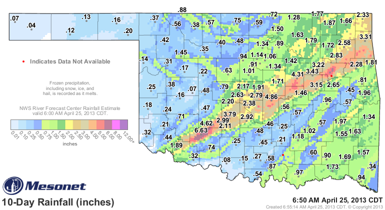
was a lot of rain for folks along the I-44 corridor, so just as a reminder, here
are the rainfall totals we had to work with for this week's U.S. Drought Monitor.
http://ticker.mesonet.org/archive/20130425/rainrfc.240hr.png
That span encompasses the big rains of last Wednesday and Thursday, which fell
after the cutoff for last week's drought map, and also the smaller bit of rain
that fell this week.
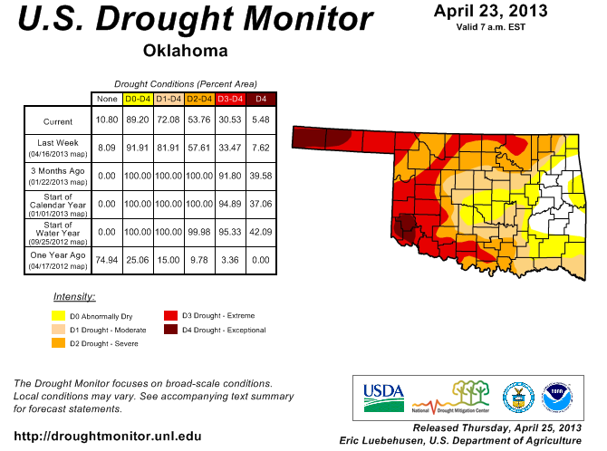
http://ticker.mesonet.org/archive/20130425/ok_dm.png
The improvements from east central through central Oklahoma leaves 28 percent
of the state without any sort of drought designation (11 percent with no
designation, 17 percent with the "Abnormally Dry, D0" designation). That still
leaves 72 percent of the state within some level of drought intensity. Only
5 percent or so is in the "Exceptional, D4" category, the best that column has
looked since July 31, 2012. Nearly 31 percent of the state is within the
"Extreme/Exceptional" categories ... a level that has not been that low since
July 17, 2012.
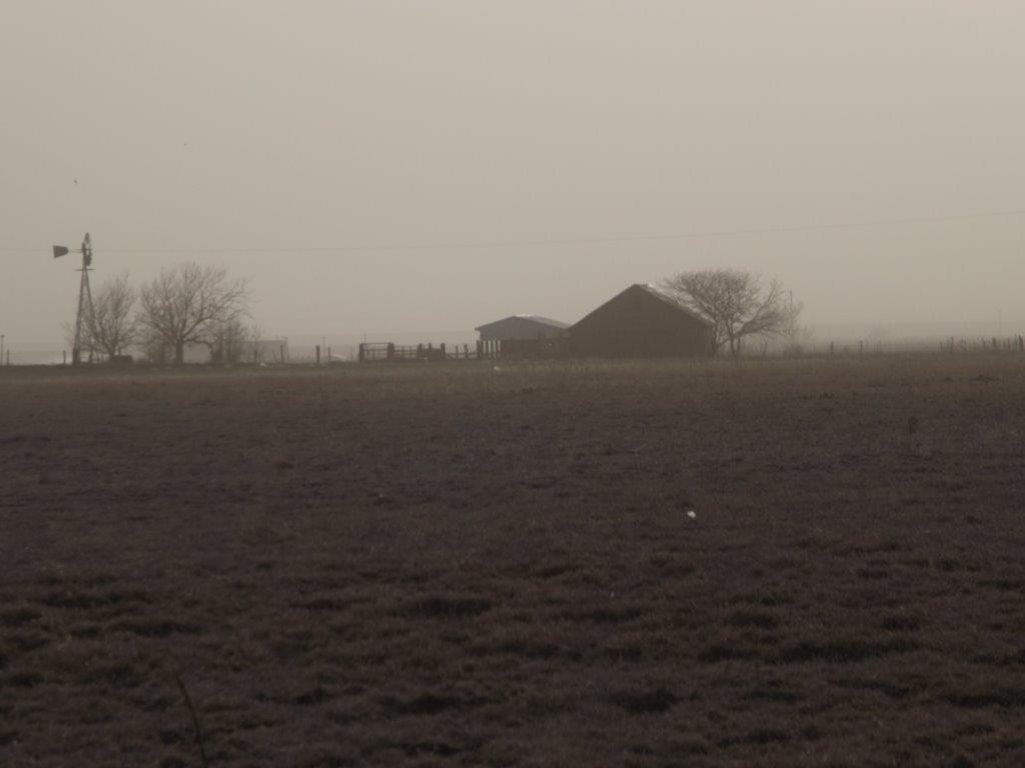
While some areas are dealing with overflowing lakes and ponds, here's what they
are dealing with in the Panhandle. Their old nemesis (nemesi? nemesises?), the
dust storm!
http://ticker.mesonet.org/archive/20130425/panhandle-dust-storm.png
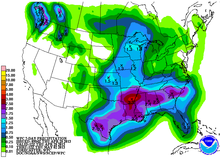
There are chances for rain coming tomorrow as well as the middle of next week.
The latest 7-day rain total forecast shows the same old story ... more for
the east and paltry amounts for the west. But that could change!
http://ticker.mesonet.org/archive/20130425/7day-rain.gif
-------------------------------------------------------------------------------
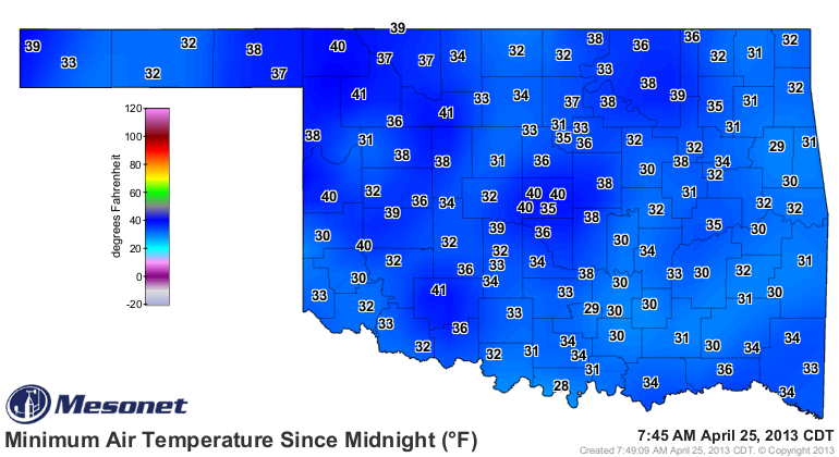
April, on the rocks
Just a bit of a freeze last night, mostly in eastern Oklahoma, left a warmer
wake-up call this morning as opposed to yesterday.
http://ticker.mesonet.org/archive/20130425/thursday-lows.png
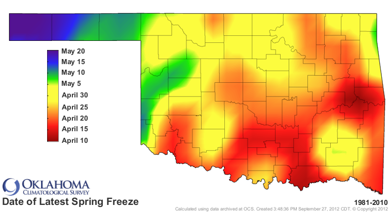
That's getting close to becoming the latest last freeze, at least based upon
the 1981-2010 data.
http://ticker.mesonet.org/archive/20130425/latest_lastfreeze.1981-2010.png
Gary McManus
Associate State Climatologist
Oklahoma Climatological Survey
(405) 325-2253
gmcmanus@mesonet.org
==================================================
The OCS/Mesonet Ticker
https://ticker.mesonet.org/
To subscribe or unsubscribe from the Ticker
or for questions about the Ticker or its content
Phone or Email the Ticker Manager at OCS
Phone: 405-325-2253 Email: ticker@mesonet.org
---------------------------------------------------
-C- Copyright 2024 Oklahoma Climatological Survey
===================================================
|


 Tweet
Tweet