MESONET TICKER ... MESONET TICKER ... MESONET TICKER ... MESONET TICKER ...
April 19, 2010 April 19, 2010 April 19, 2010 April 19, 2010
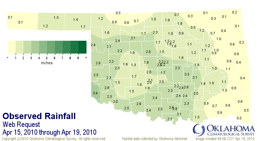
Mesonet Rainfall Totals
The storm-total rainfall amounts for this weekend's storm were quite impressive!
Just in the nick of time to help curtail any adverse effects the dry weather might
have caused this year's wheat crop. Most of the state saw between 1-3 inches with
a few spots even exceeding that. Here are the Mesonet totals that exceeded 2
inches:
Hollis 3.39" Pauls Valley 2.35"
Bowlegs 3.26" Bessie 2.34"
Madill 3.10" Shawnee 2.34"
Cheyenne 2.93" Altus 2.33"
Mangum 2.80" Breckinridge 2.32"
Ardmore 2.79" Retrop 2.32"
Ada 2.61" Tishomingo 2.30"
Walters 2.57" Butler 2.24"
Newport 2.56" Burneyville 2.20"
Kingfisher 2.56" Spencer 2.19"
Erick 2.55" Byars 2.17"
Ringling 2.52" Putnam 2.17"
Grandfield 2.52" OKC North 2.17"
OKC West 2.51" OKC East 2.16"
Waurika 2.44" Fairview 2.15"
Vanoss 2.44" Holdenville 2.15"
Fittstown 2.43" Camargo 2.07"
Seiling 2.42" Chickasha 2.06"
Arnett 2.40" Tipton 2.04"
Ketchum Ranch 2.37" Ninnekah 2.03"
Sulphur 2.36" Centrahoma 2.00"
Here are the lowest totals:
Sallisaw 0.42"
Wister 0.42"
Nowata 0.35"
Foraker 0.34"
Westville 0.25"
Miami 0.19"
Kenton 0.14"
Copan 0.13"
Vinita 0.13"
Jay 0.10"
Boise City 0.08"
Totals in map view:
http://ticker.mesonet.org/archive/20100419/total_rainfall.png
Gary McManus
Associate State Climatologist
Oklahoma Climatological Survey
(405) 325-2253
gmcmanus@mesonet.org
==================================================
The OCS/Mesonet Ticker
https://ticker.mesonet.org/
To subscribe or unsubscribe from the Ticker
or for questions about the Ticker or its content
Phone or Email the Ticker Manager at OCS
Phone: 405-325-2253 Email: ticker@mesonet.org
---------------------------------------------------
-C- Copyright 2024 Oklahoma Climatological Survey
===================================================
|


 Tweet
Tweet