MESONET TICKER ... MESONET TICKER ... MESONET TICKER ... MESONET TICKER ...
April 1, 2016 April 1, 2016 April 1, 2016 April 1, 2016
Fire, Tornadoes Steal March Weather Headlines
http://ticker.mesonet.org/archive/20160401/hart.jpg
The dry weather that had plagued the state during the first two months of 2016
continued during March. Drought conditions spread across nearly all of
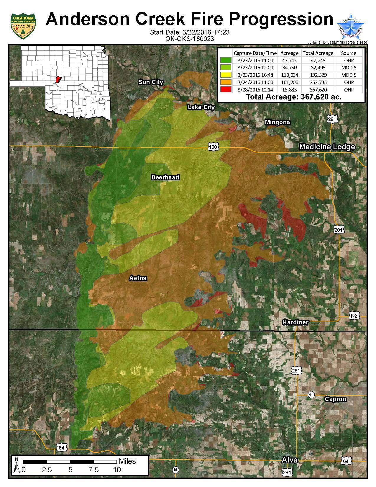
northwestern Oklahoma and aided the massive Anderson Creek wildfire that burned
367,620 acres across Woods County in Oklahoma and the adjacent counties in
southern Kansas. The total acreage burned in Oklahoma amounted to 88,082, all
within Woods County. The fire, whipped by winds of over 60 mph, began on March 22
near Camp Houston in Woods County before quickly spreading to the north and then
east.
http://ticker.mesonet.org/archive/20160401/anderson.creek.burn.map.jpg
Oklahoma Forestry Services estimated more than 1,000 bales of hay, hundreds of
miles of fence and approximately 600 livestock were lost in the Oklahoma
portion of the fire, and altogether 16 residential structures and 25 other
structures were burned in Kansas and Oklahoma. The fire was the fourth largest
to occur east of the Rockies in at least the last two decades according to the
National Interagency Fire Center. Many other smaller fires burned in other
areas of the state throughout the month.
The month?s other big weather story was the outbreak of severe weather on March
30. A strong upper-level storm system and associated surface front, complete
with a distinct dryline, kicked off storms early in the afternoon across south
central and central Oklahoma, some of which quickly became severe. The worst
storms were saved for northeastern Oklahoma later in the evening. The National
Weather Service office in Tulsa reported two tornadoes on the night, both rated
EF-2 in strength. The first started south of Skiatook in Osage County and
traveled through north Tulsa before lifting near Verdigris in Rogers County.
Significant damage and four injuries were reported with this tornado. That same
storm then produced another tornado near Claremore, again producing significant
damage.
http://kamala.cod.edu/ok/latest.nous44.KTSA.html
Other reports of large hail, strong winds and torrential downpours were noted
from south central up through northeastern Oklahoma during the day.
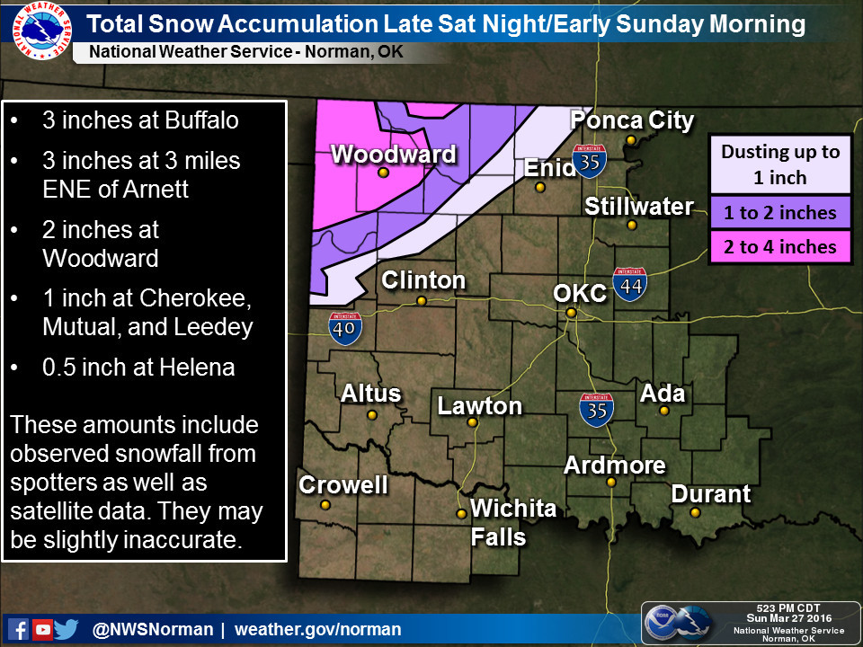
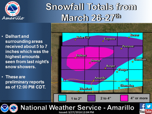
Other notable events during March include a late snowfall on Eastern Sunday, a
late freeze, and an increase in drought conditions across northwestern Oklahoma.
The snowfall amounts on the 27th were generally between 2-4 inches and confined
to the Panhandle and far northwestern Oklahoma. Laverne led preliminary totals
with 6 inches.
http://ticker.mesonet.org/archive/20160328/nws-norman-snow.jpg
http://ticker.mesonet.org/archive/20160328/nws-amarillo-snow.gif
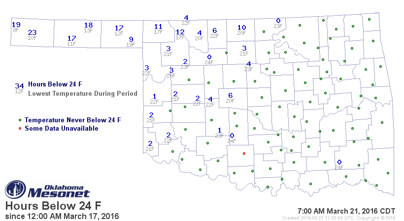
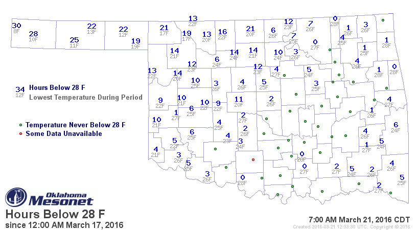
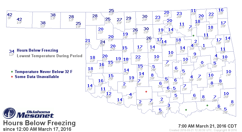
The week before, a cold front ushered in frigid air that dropped minimum
temperatures well below seasonal norms. From March 18-21, much of the state had
spent at least 10 hours below freezing according to the Mesonet, with the
northwestern quarter seeing temperatures drop below 24 degrees for similar time
periods.
http://ticker.mesonet.org/archive/20160321/hours-below-24degrees.png
http://ticker.mesonet.org/archive/20160321/hours-below-28degrees.png
http://ticker.mesonet.org/archive/20160321/hours-below-32degrees.png
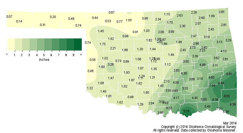
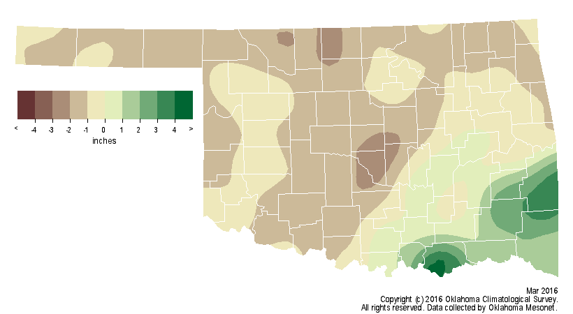
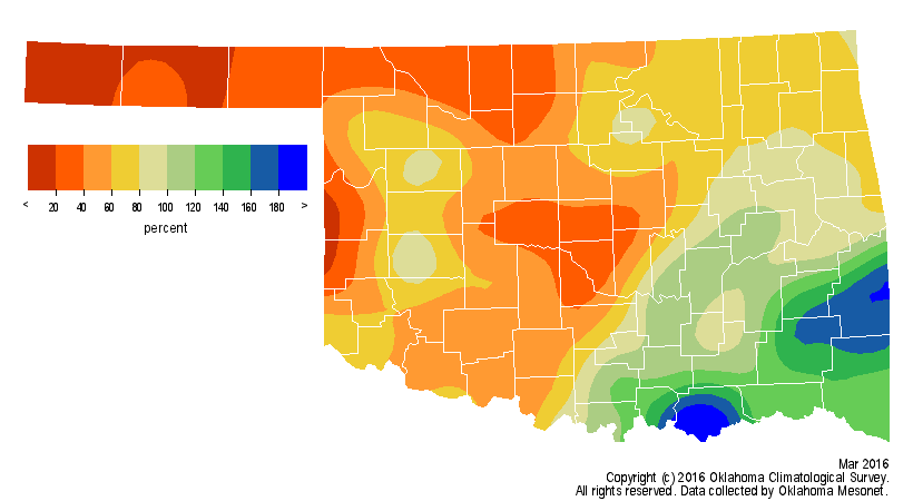
According to preliminary data from the Oklahoma Mesonet, the March statewide
average rainfall total was 2.4 inches, more than half an inch below normal.
That total was a bit deceptive, however, due to heavy rainfall across the
southeastern quarter of the state. Most other areas were from 1-2 inches below
normal.
http://ticker.mesonet.org/archive/20160401/march-rain-totals.png
http://ticker.mesonet.org/archive/20160401/march-rain-depart.png
http://ticker.mesonet.org/archive/20160401/march-rain-pct.png
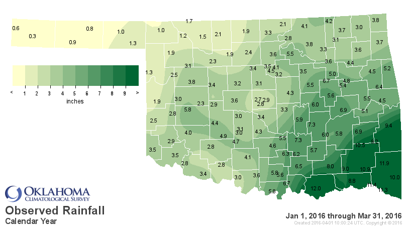
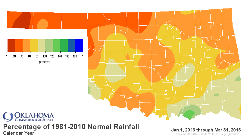
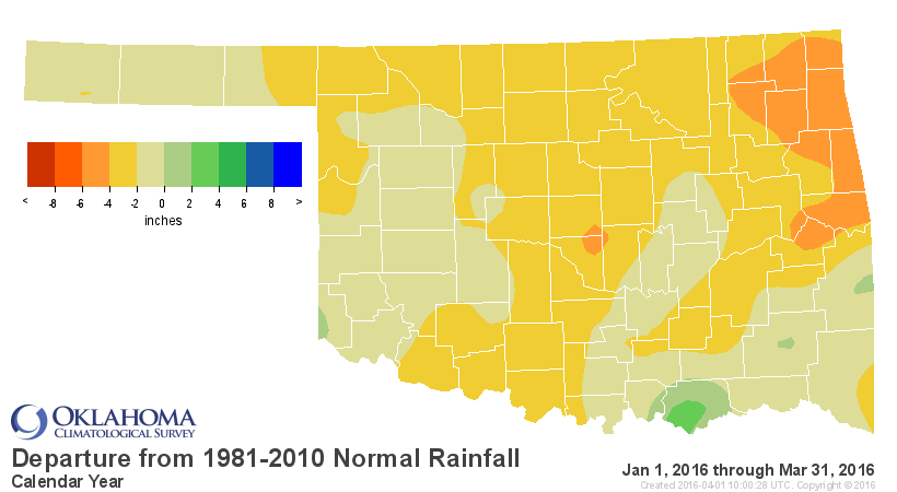
That brought the year-to-date statewide average to 3.8 inches, 2.6 inches below
normal, to rank as the 30th driest January-March since records began in 1895.
The Panhandle and north central Oklahoma saw their 19th- and 20th-driest first
three months of the year, respectively.
http://ticker.mesonet.org/archive/20160401/caltot.png
http://ticker.mesonet.org/archive/20160401/calpct.png
http://ticker.mesonet.org/archive/20160401/caldel.png
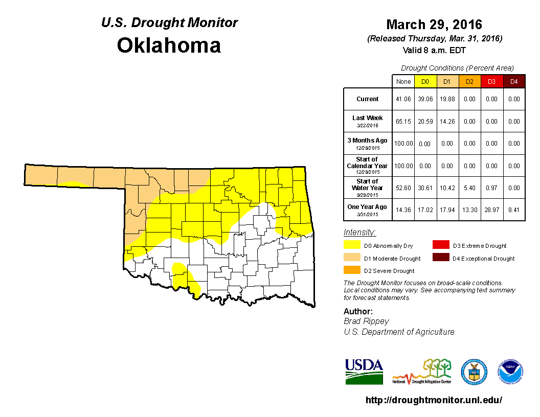
That dry stretch allowed moderate drought to span nearly 20 percent of the
state according to the March 29 U.S. Drought Monitor report, all in the
northwestern corner of the state. In addition, more than 39 percent of the
state was considered to be abnormally dry, a precursor to drought.
http://ticker.mesonet.org/archive/20160401/20160329_OK_cat.png
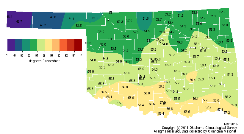
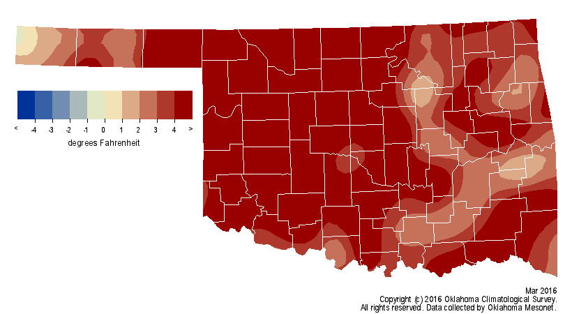
Warmer than normal weather aided the intensifying drought. The statewide
average as measured by the Mesonet was 54.2 degrees, 3.8 degrees above normal
and the 18th warmest March on record.
http://ticker.mesonet.org/archive/20160401/march-avg-temps.png
http://ticker.mesonet.org/archive/20160401/march-temps-depart.png
Combined with the warm start to the year, that brought the January-March
statewide average to 46.6 degrees, the 12th warmest such period on record.
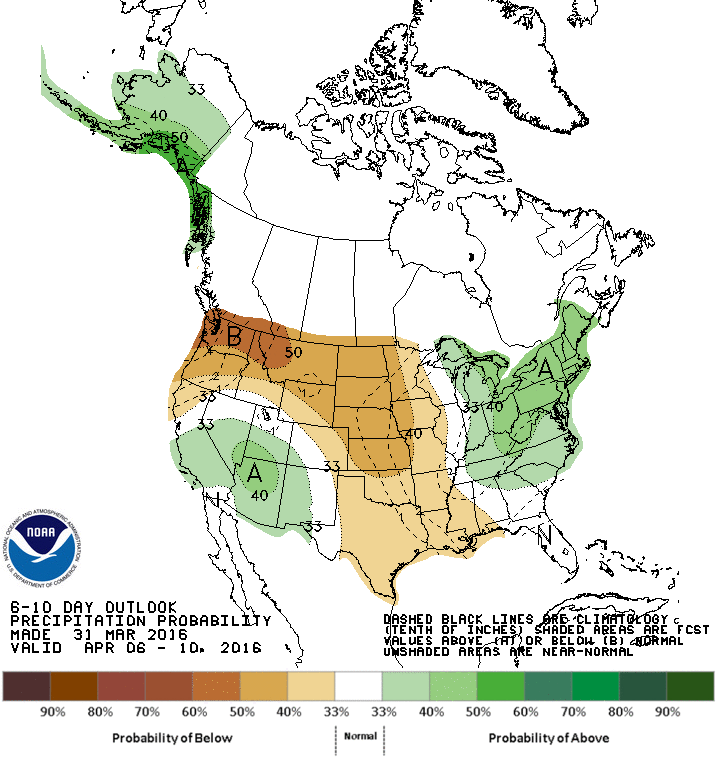
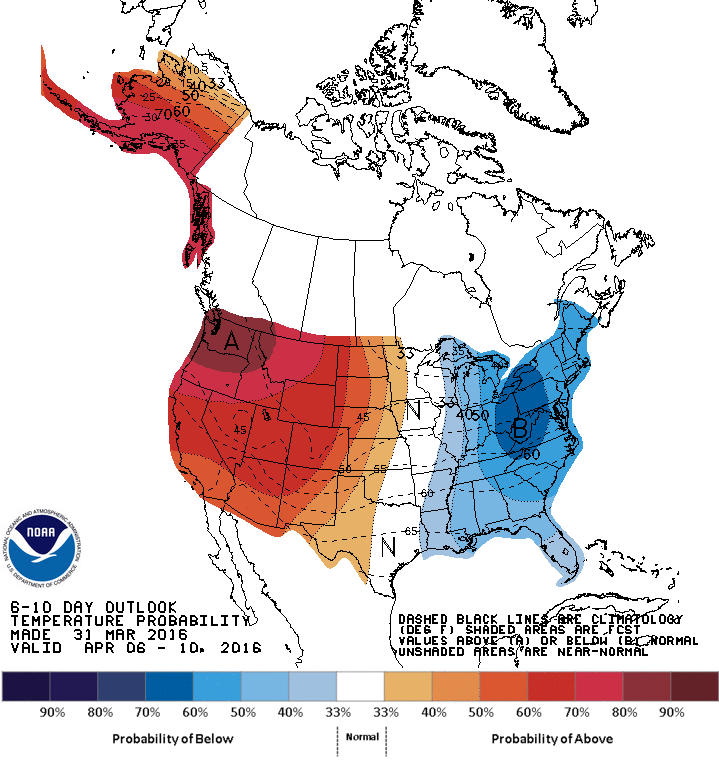
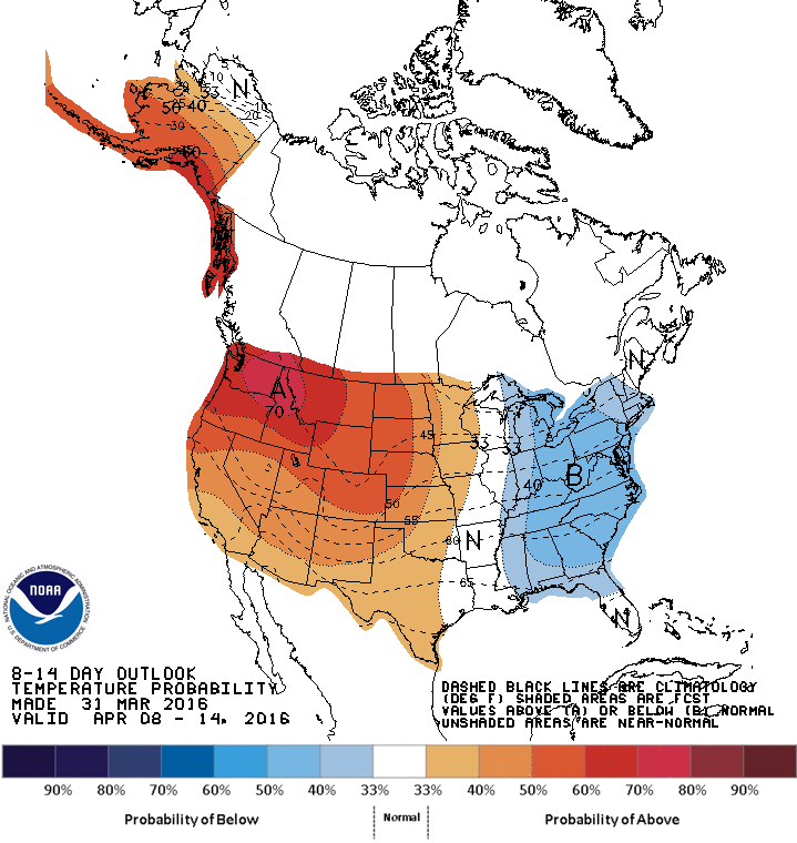
A look to the future shows dry and warm weather possibly continuing for the
first 10 days of April before wetter conditions materialize.
http://ticker.mesonet.org/archive/20160401/610prcp.new.gif
http://ticker.mesonet.org/archive/20160401/610temp.new.gif
http://ticker.mesonet.org/archive/20160401/814prcp.new.gif
http://ticker.mesonet.org/archive/20160401/814temp.new.gif
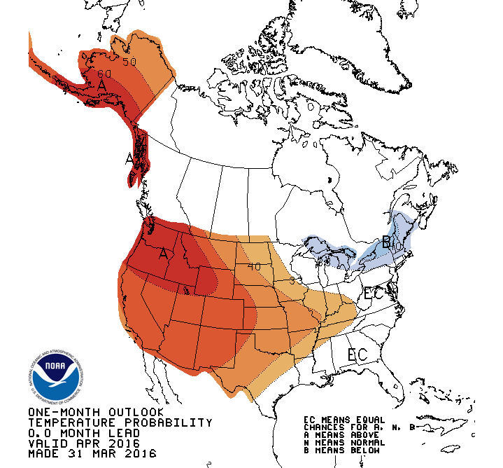
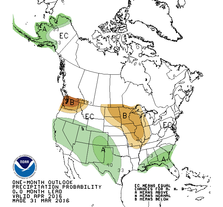
The Climate Prediction Center?s April precipitation outlook indicates increased
odds for above normal rainfall across the western third of the state,
especially across the western Panhandle. The outlook for temperature shows
increased odds for above normal temperature across the entire state, but again
especially across the western Panhandle.
http://ticker.mesonet.org/archive/20160401/april-temp-outlook.gif
http://ticker.mesonet.org/archive/20160401/april-precip-outlook.gif
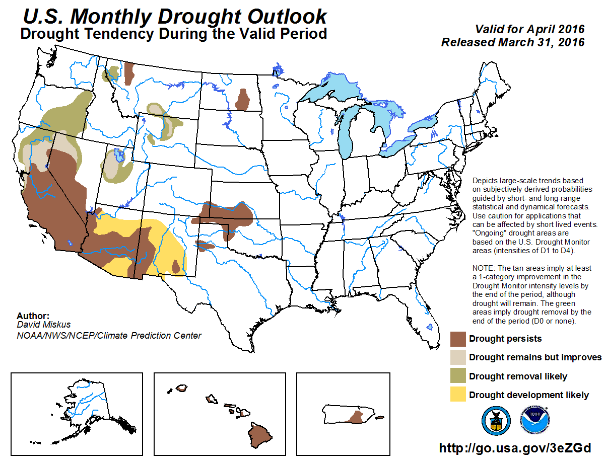
Despite the wet signal across the northwest, the U.S. Monthly Drought Outlook
forecasts the current drought conditions across the northwest to continue
through April, but no further drought is expected to develop by the end of the
month.
http://ticker.mesonet.org/archive/20160401/month_drought.png
Gary McManus
State Climatologist
Oklahoma Mesonet
Oklahoma Climatological Survey
(405) 325-2253
gmcmanus@mesonet.org
==================================================
The OCS/Mesonet Ticker
https://ticker.mesonet.org/
To subscribe or unsubscribe from the Ticker
or for questions about the Ticker or its content
Phone or Email the Ticker Manager at OCS
Phone: 405-325-2253 Email: ticker@mesonet.org
---------------------------------------------------
-C- Copyright 2024 Oklahoma Climatological Survey
===================================================
|


 Tweet
Tweet