MESONET TICKER ... MESONET TICKER ... MESONET TICKER ... MESONET TICKER ...
April 1, 2010 April 1, 2010 April 1, 2010 April 1, 2010
March Weather Brought Mixed Bag
Data from the Oklahoma Mesonet, Oklahoma?s weather network, show that March ended
a little drier and cooler than normal across most of the state. The statewide
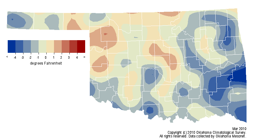
average temperature came in at more than a degree below normal to rank as the
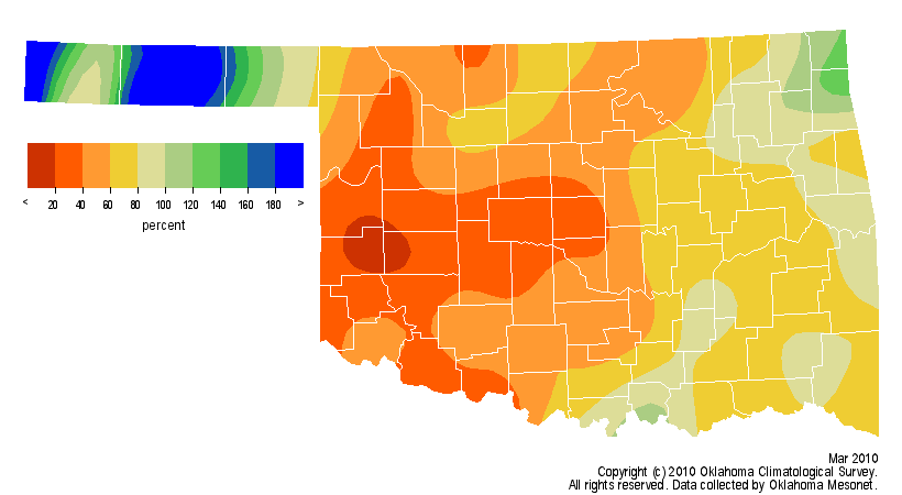
55th coolest March since 1895. The statewide average precipitation total finished
more than an inch below normal to rank the month as the 44th driest. Rainfall
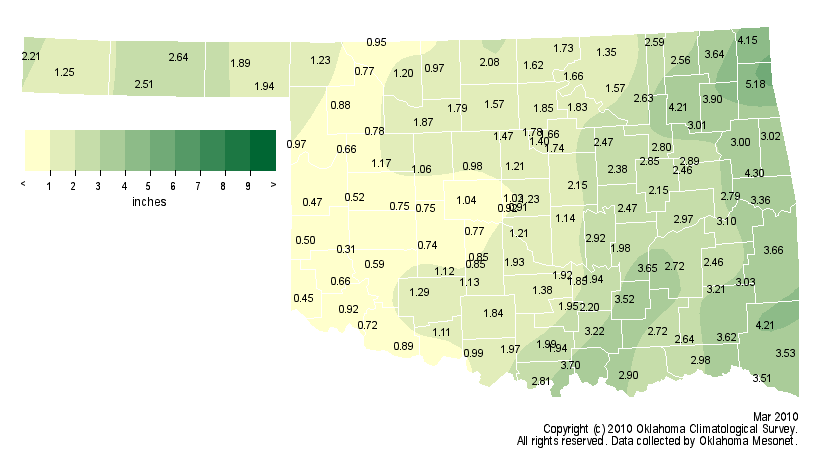
totals from the Mesonet ranged from about a third of an inch in the southwest to
more than 5 inches in the extreme northeast. The Panhandle was the wettest region,
on average, experiencing its 23rd wettest March on record. Southwestern Oklahoma
finished nearly 1.5 inches below normal for the month and ranked as 28th driest.
http://ticker.mesonet.org/archive/20100401/avgtavg.png
http://ticker.mesonet.org/archive/20100401/delrain.png
http://ticker.mesonet.org/archive/20100401/deltavg.png
http://ticker.mesonet.org/archive/20100401/pctrain.png
http://ticker.mesonet.org/archive/20100401/totrain.png
The biggest weather stories during March will not come as a shock to those
accustomed to Oklahoma?s wild weather. The first was a tornado on the eighth
that struck the small town of Hammon in Roger Mills County. The EF2-rated
twister gave the town a glancing blow and left damaged homes and businesses in
its wake. The next major weather event was a late-month snowstorm that dumped
from 3-7 inches of snow across the northern half of the state. Pryor led the
state?s totals with 11 inches. The final big weather story occurred as the
month waned. Temperatures soared into the 90s in western Oklahoma during
March?s final three days. The heat combined with low humidities and strong
winds gusting to over 40 mph and to produce extreme fire danger.
The Mesonet sites at Butler and Seiling recorded the state?s highest temperature,
97 degrees, on the 31st. The lowest temperature of 15 degrees occurred on the
21st at Boise City. Jay had the most precipitation with 5.18 inches while the
Retrop Mesonet site in Washita County brought up the rear with 0.31 inches.
The April outlooks from the National Weather Service show an increased chance
of above normal rainfall for the state but no clear indication of above- or
below-normal temperatures.
Gary McManus
Associate State Climatologist
Oklahoma Climatological Survey
(405) 325-2253
==================================================
The OCS/Mesonet Ticker
https://ticker.mesonet.org/
To subscribe or unsubscribe from the Ticker
or for questions about the Ticker or its content
Phone or Email the Ticker Manager at OCS
Phone: 405-325-2253 Email: ticker@mesonet.org
---------------------------------------------------
-C- Copyright 2024 Oklahoma Climatological Survey
===================================================
|


 Tweet
Tweet