MESONET TICKER ... MESONET TICKER ... MESONET TICKER ... MESONET TICKER ...
February 19, 2024 February 19, 2024 February 19, 2024 February 19, 2024
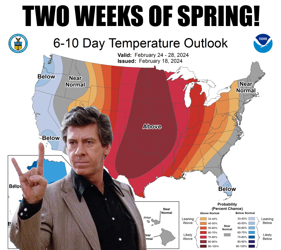
Screws fall out, sir
https://ticker.mesonet.org/archive/20240219/feb24-28-temp-outlook.png
Fresh back from my trip to Washington D.C. where I ran for President.
Didn't win, though.
Did ya miss me? Well, too bad because you won't get a better shot. I'm quite good
at dodging (MASSIVE SEGUE ALERT!!), and speaking of dodging...looks like we're
gonna dodge any winter weather for the rest of February. At least as wintery as
winters can be during February in Oklahoma. Of course we will still have some
cold mornings, but not the teens and 20s that we saw over the weekend.
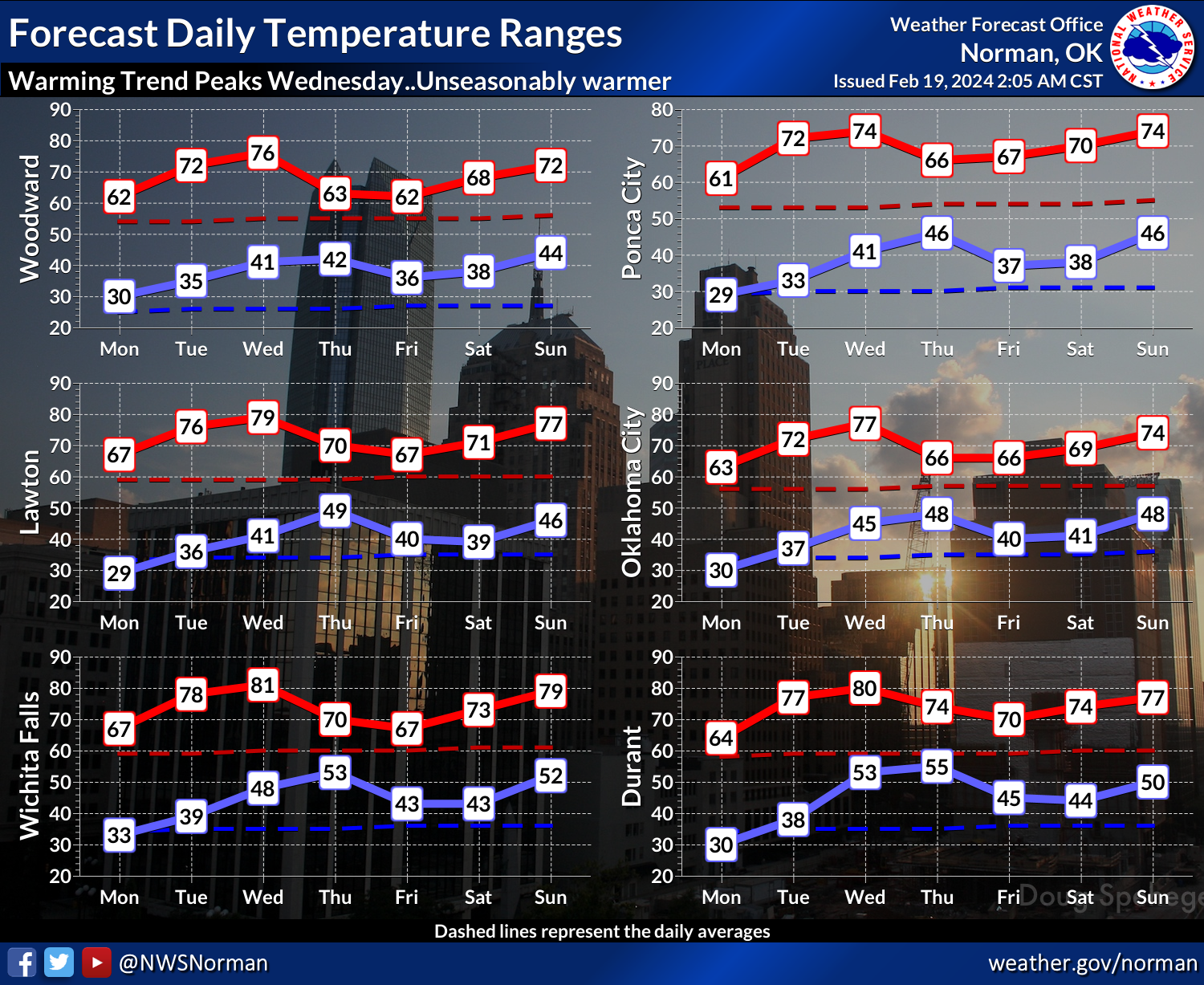
https://ticker.mesonet.org/archive/20240219/nws-norman-7day-temps.png
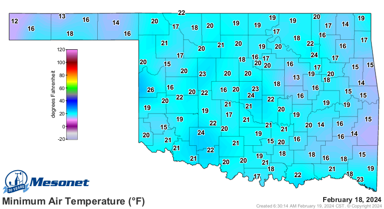
https://ticker.mesonet.org/archive/20240219/sundays-lows.png
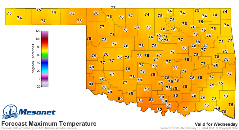
In fact, we should see our first 80s in the state since Dec. 8 when Burneyville
reached that mark.
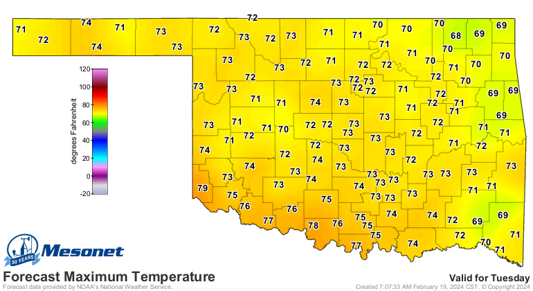
https://ticker.mesonet.org/archive/20240219/tuesday-forecast-highs.png
https://ticker.mesonet.org/archive/20240219/wednesday-forecast-highs.png
Those skyrocketing temps on Wednesday, given that it's February, usually signal
the approach of a frontal system, with its gusty SW winds ahead of it bringing
up those temperatures. The winds will gust from 30-40 mph, which will kill the
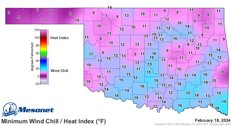
joy of those 70s and 80s a bit, but it's a darned sight better than this from
yesterday.
https://ticker.mesonet.org/archive/20240219/yesterdays-min-wind.chills.png
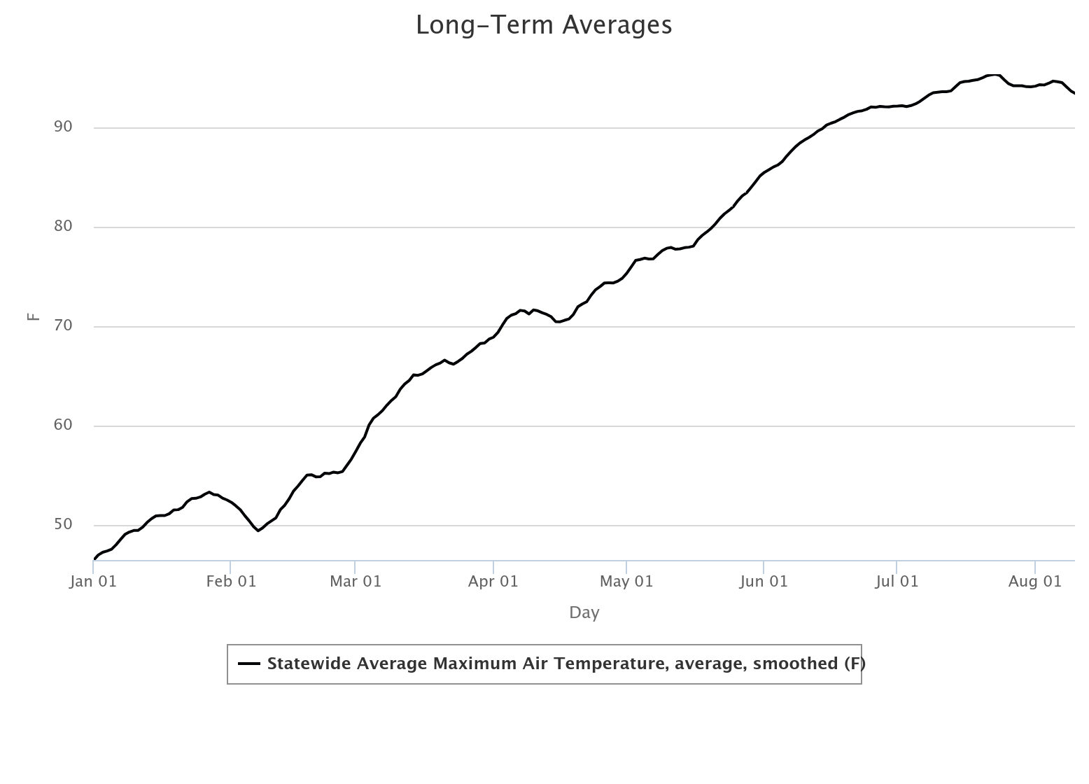
We'll cool down on Thursday, but down into the 60s as we continue our march
forward with increasing normal temps from which our highs and lows will
oscillate with each passing weather system--or lack thereof.
https://ticker.mesonet.org/archive/20240219/longterm-avg.highs.png
Here's the kicker though...a bigtime cold front in January is no big deal. It's
January. Hellooooo...McFly! But a bigtime cold front in March, after an extended
non-freezing period to end February? Well, that could spell disaster, and those
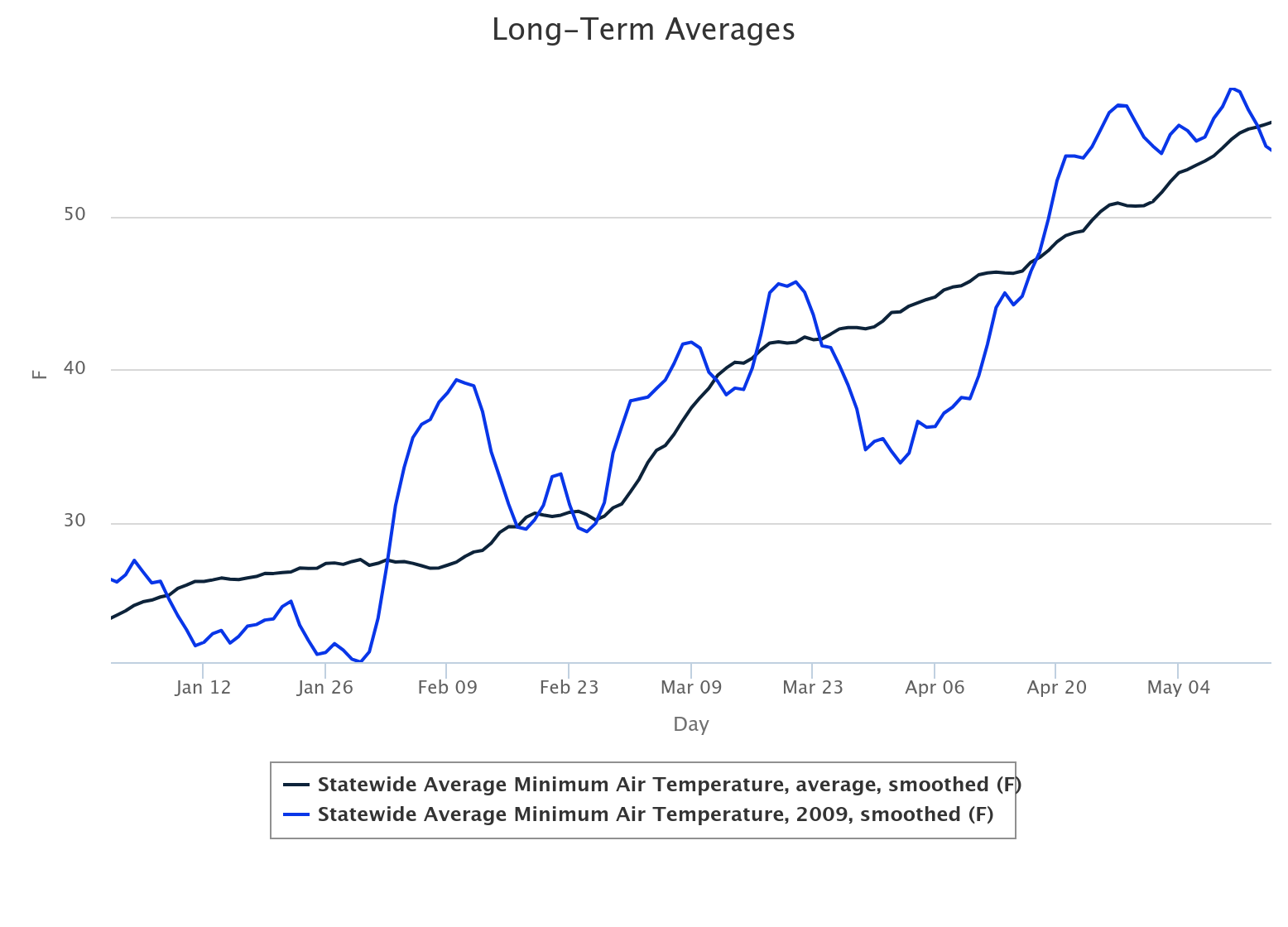
threats extend into April as well. Take 2009, for instance, one of the worst
freeze-damage episodes for Oklahoma's winter wheat crop in recent (ahem!)
memory. Check out this graph of statewide average low temps (blue), vs. the
long-term average (black).
https://ticker.mesonet.org/archive/20240219/2009-avg-lows.png
Notice how the weather--at least the lows--were above normal for much of February
and March, only to see a massive drop in late March and the first half of April.
One of the first few Tickers I wrote was on a disastrous freeze that year, 2009.
https://ticker.mesonet.org/select.php?mo=04&da=07&yr=2009
An unusually warm stretch in late winter doesn't always spell doom, however, and
we don't want to leave you with that impression. Something to watch, and we
will.
Other than that, the weather is once again like myself...fairly boring and
relatively dry, with just a hint of madness.
https://ticker.mesonet.org/archive/20240219/7day-rain-forecast.gif
Surely we'll pay for this in March? Or April?
Don't mess with the bull, Oklahoma. You'll get the horns.
Gary McManus
State Climatologist
Oklahoma Mesonet
Oklahoma Climatological Survey
gmcmanus@mesonet.org
==================================================
The OCS/Mesonet Ticker
https://ticker.mesonet.org/
To subscribe or unsubscribe from the Ticker
or for questions about the Ticker or its content
Phone or Email the Ticker Manager at OCS
Phone: 405-325-2253 Email: ticker@mesonet.org
---------------------------------------------------
-C- Copyright 2024 Oklahoma Climatological Survey
===================================================
|


 Tweet
Tweet