MESONET TICKER ... MESONET TICKER ... MESONET TICKER ... MESONET TICKER ...
February 10, 2021 February 10, 2021 February 10, 2021 February 10, 2021
Tin anniversary of -31 degrees
http://ticker.mesonet.org/archive/20210210/feb10-2011.png
Hey, it's the Tin anniversary of the lowest temperature ever recorded in Oklahoma,
-31 degrees at the Nowata Mesonet site, back on Feb. 10, 2011. Did you know that
the 10th anniversary was known as the "tin" anniversary? Well aren't you smart!
In my house, it was known as the "let's go to Golden Corral" anniversary.
Jealous??
Not only did we measure the lowest temperature ever recorded in the state, the
Mesonet also captured the lowest wind chill ever recorded, -47 degrees at the
Medford site.
http://ticker.mesonet.org/archive/20210210/feb10-2011-wind.chills.png
Now we've never come close to either of those records since that fateful day
back in 2011, so both the top-Whatever lists are still intact:
-***-
Lowest Temperatures by Station, Mesonet or NWS COOP
Location Date Temperature (F)
Nowata Mesonet 2/10/2011 -31
Pryor Mesonet 2/10/2011 -28
BARTLESVILLE 2/10/2011 -28
WATTS 1/18/1930 -27
VINITA 2 N 2/13/1905 -27
Guthrie 1/04/1947 -27
Medford Mesonet 2/10/2011 -27
Blackwell Mesonet 2/10/2011 -27
PAWHUSKA 1/22/1930 -26
VINITA 2 N 1/22/1930 -26
WATTS 1/22/1930 -26
PONCA CITY 2/10/2011 -25
Marshall Mesonet 2/10/2011 -25
-****-
-***-
Lowest Wind Chill by Station, Mesonet, since 1997
Site Date Wind Chill (F)
Medford 2/10/2011 -47
Cherokee 2/10/2011 -40
Marshall 2/10/2011 -39
Breckenridge 2/10/2011 -38
Blackwell 2/10/2011 -38
Redrock 2/10/2011 -38
Nowata 2/10/2011 -38
Pryor 2/10/2011 -36
Boise City 2/10/2011 -36
Freedom 2/10/2011 -35
-****-
Now it's doubtful we'll need the top list, but the wind chill list *MIGHT* be
threatened, at least at the lower end, before this whole winter craze is
finished. Don't quote me on that, but if you do, be kind. I just switched to
Sanka.
In the more immediate term, we're dealing with more freezing drizzle/rain,
bitter cold, and then some possible snow this weekend. The impact of that snow
will be significant if it is heavy, since we're not going to see above freezing
weather until July, or late next week, whichever comes first. Hey, it's 2021,
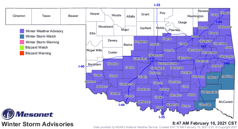
anything is possible! We have a winter weather advisory for much of the SE half
and-just-a-bit-more of the state, then a winter storm watch farther southeast
where some heavier freezing rain could fall.
http://ticker.mesonet.org/archive/20210210/latest.oklahoma.winter.gif
If you're in the purple or blue, try not to travel. Temperatures have been
positively dreadful already this morning, which is better than we'll see this
weekend, when it could be negatively dreadful. Our wind chill map is impacted
by the frozen precip of the previous two days, but a few stations help fill in
the gaps up north.
http://ticker.mesonet.org/archive/20210210/todays-min-windchills.png
http://ticker.mesonet.org/archive/20210210/todays-lows.png
Don't expect much movement in the temperatures today, or tomorrow, or the next
7-8 days at least, unless it's downward. The weekend definitely looks worse,
however. Here are a couple of maps of what we can expect, from our NWS friends.
And by couple I mean three.
http://ticker.mesonet.org/archive/20210210/nws-amarillo-weekend.snow.png
http://ticker.mesonet.org/archive/20210210/nws-amarillo-weekend.chill.png
http://ticker.mesonet.org/archive/20210210/nws-norman-weekend.chill.png
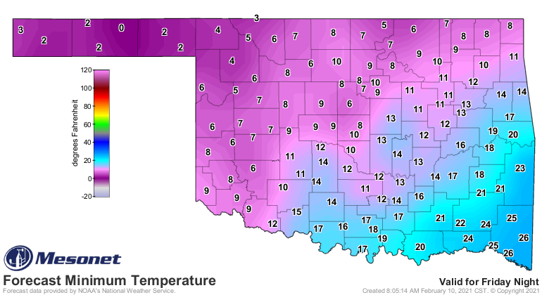
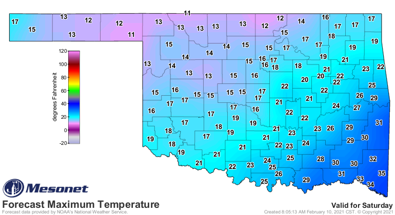
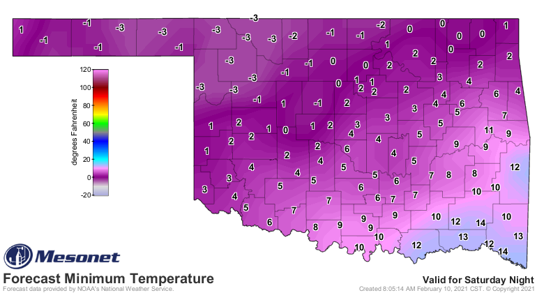
Air temperature forecasts for this weekend:
http://ticker.mesonet.org/archive/20210210/saturday-morning-lows.png
http://ticker.mesonet.org/archive/20210210/saturday-highs.png
http://ticker.mesonet.org/archive/20210210/sunday-morning-lows.png
http://ticker.mesonet.org/archive/20210210/sunday-highs.png
Snow amounts are very uncertain at this time, so definitely stay weather aware.
I'm certain you're cold aware already. Hopefully all records will stay intact,
including the other big record from 10 years ago today, the 27 inches of snow
that fell in Spavinaw...the highest 24-hour total in state history.
Gary McManus
State Climatologist
Oklahoma Mesonet
Oklahoma Climatological Survey
(405) 325-2253
gmcmanus@mesonet.org
==================================================
The OCS/Mesonet Ticker
https://ticker.mesonet.org/
To subscribe or unsubscribe from the Ticker
or for questions about the Ticker or its content
Phone or Email the Ticker Manager at OCS
Phone: 405-325-2253 Email: ticker@mesonet.org
---------------------------------------------------
-C- Copyright 2024 Oklahoma Climatological Survey
===================================================
|


 Tweet
Tweet