MESONET TICKER ... MESONET TICKER ... MESONET TICKER ... MESONET TICKER ...
February 9, 2017 February 9, 2017 February 9, 2017 February 9, 2017
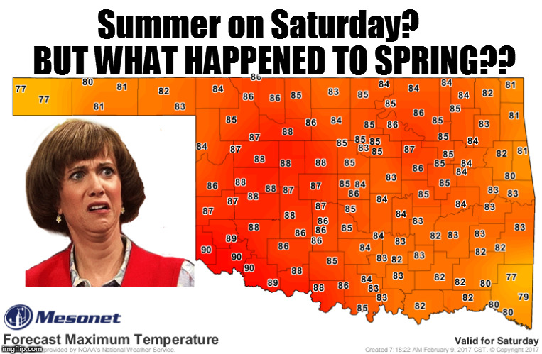
Summer is nigh...for one day
http://ticker.mesonet.org/archive/20170209/Febru-summer.jpg
By the way, why is that first "r" there in "February?" If I was spelling it first,
I'd have spelled it "Febyouwary." And why do you have to put the punctuation
INSIDE the quotation marks? And also, why are we going to have June temperatures
in Feyouwary? CRAZY! Well, not really. It's happened before and I'm sure it will
happen again. But this temperature roller coaster ride is playing havoc with
not only our wardrobe choices, but our ability to stamp a little drought out
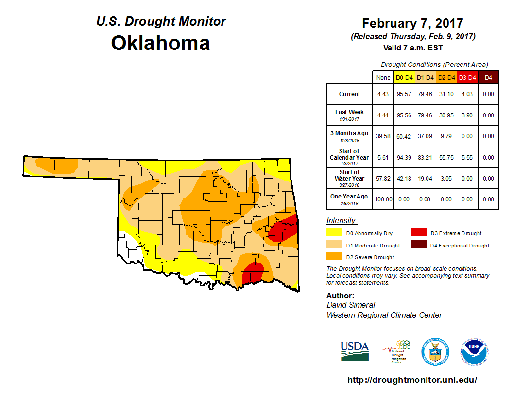
here and there. The latest U.S. Drought Monitor map shows drought still going
strong in Oklahoma, and getting stronger day by day.
http://ticker.mesonet.org/archive/20170209/20170207_OK_trd.png
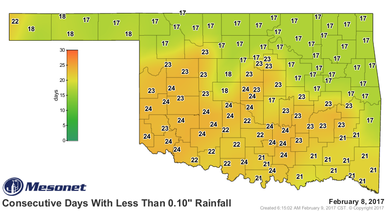
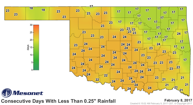
And I warned ya. I told ya it was going to happen. Here's the news in my best
Okie-ese: We've done gone to orange on the consecutive days without a quarter-inch
and tenth of an inch maps.
http://ticker.mesonet.org/archive/20170209/mesonet.rainfall.tenthinch.png
http://ticker.mesonet.org/archive/20170209/mesonet.rainfall.quarterinch.png
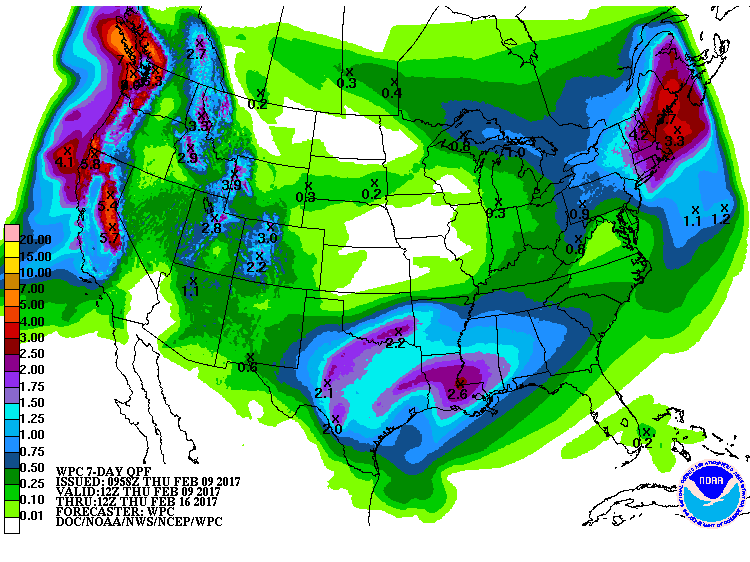
Our big Jan. 13-16 storm system is about to fall off the 30-day rainfall maps
and those are going to look pretty scary if we don't get rain soon. Oh, rain
soon? Glad you asked. There will be a chance of rain with an upper-level
storm system that approaches the state, maybe-possibly, early next week. The
trouble with this forecast is that it's a cutoff upper-level low (famously
known as "weatherperson's woe" since its difficult for the forecast models to
handle. It's out of the obvious flow pattern of the atmosphere (thus, the term
"cutoff low." It's doing its own thing. At any rate, there will be a chance of
rain coming up, and this follows a strong cold front on Sunday, so there will
be a chance of snow-that-melt-before-or-quickly-after-it-hits-the-ground. These
forecast amounts have been all over the map...literally, so take them with a
grain of salt. Okay, skip the salt in case it doesn't rain.
http://ticker.mesonet.org/archive/20170209/7day-rain-forecast.gif
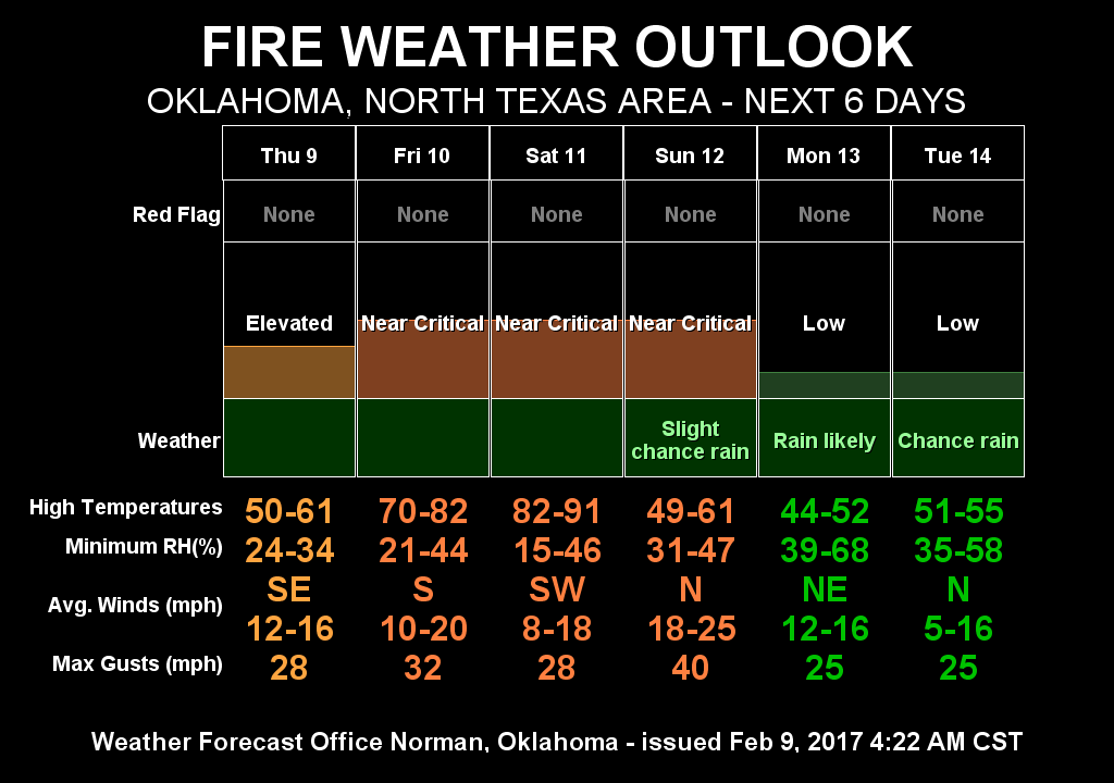
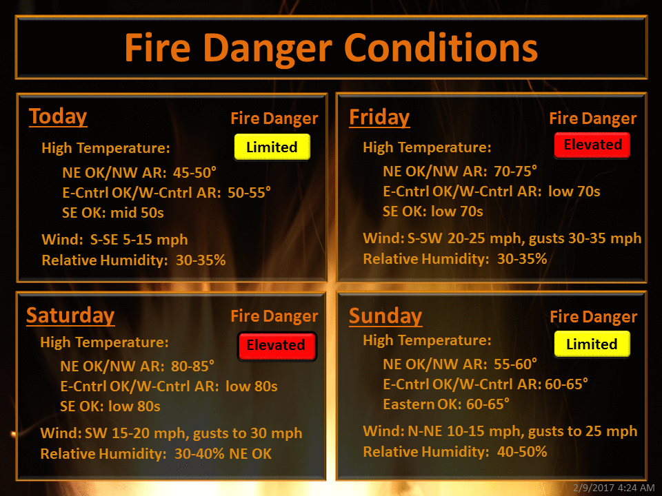
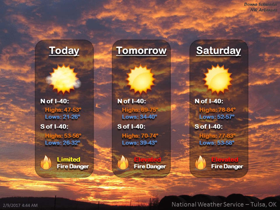
Until then, however, we're going to be in Fire Danger City. You know with all
that heat, dead/dormant vegetation and strong winds that it was going to pop
up. Well, consider it popped.
http://ticker.mesonet.org/archive/20170209/nws-norman-fire.danger.png
http://ticker.mesonet.org/archive/20170209/nws-tulsa-fire.danger.1.png
http://ticker.mesonet.org/archive/20170209/nws-tulsa-fire.danger.2.png
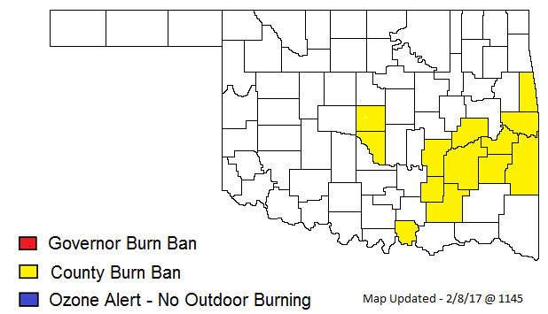
If life gives you fire danger, make s'mores? NO! Just don't burn anything
outdoors, especially in these counties or you could be subject to...well, I'm
sure it's something bad.
http://ticker.mesonet.org/archive/20170209/BurnBanMap02817A.png
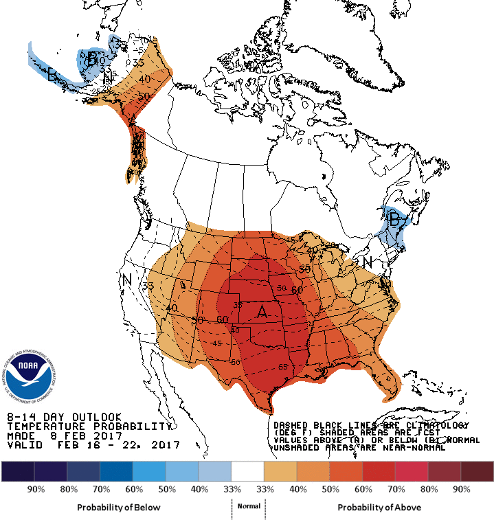
Winter returns Monday. Blah. Don't get used to it though.
http://ticker.mesonet.org/archive/20170209/feb16-22-temp-outlook.gif
State Climatologist out!
Gary McManus
State Climatologist
Oklahoma Mesonet
Oklahoma Climatological Survey
(405) 325-2253
gmcmanus@mesonet.org
==================================================
The OCS/Mesonet Ticker
https://ticker.mesonet.org/
To subscribe or unsubscribe from the Ticker
or for questions about the Ticker or its content
Phone or Email the Ticker Manager at OCS
Phone: 405-325-2253 Email: ticker@mesonet.org
---------------------------------------------------
-C- Copyright 2024 Oklahoma Climatological Survey
===================================================
|


 Tweet
Tweet