MESONET TICKER ... MESONET TICKER ... MESONET TICKER ... MESONET TICKER ...
February 7, 2013 February 7, 2013 February 7, 2013 February 7, 2013
Good news ... past, present and future
This is sort of the triumvirate of drought news I've been waiting to talk about
for months. And months. And months. We finally have an improved U.S. Drought
Monitor map to show, and rain forecast for today, and then more rain forecast for
the weekend. It doesn't get much better than that for a drought-weary state. Let's
state right off with the newest Drought Monitor. On it you can see a good bit
of improvement from the northeast down through southeastern Oklahoma. There
was a downgrade of the western Panhandle from Severe (D2) to Extreme (D3) and
you'll see why in a minute. The amount of D4 stayed the same at 40%, but the
amount of D3 dropped to 90% or so. It's not a massive improvement, but it's
progress in the proper direction. The improvements in he east were offset a bit
by the addition of D3 to the far western Panhandle.
http://ticker.mesonet.org/archive/20130207/ok_dm.png
Those improved areas aren't the only places that received rain, of course, but
that's where they've gotten the best totals over the last month or so.
http://ticker.mesonet.org/archive/20130207/30day-rain.png
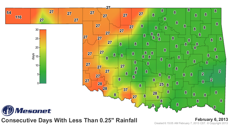
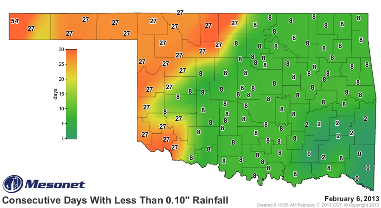
Unfortunately, the far western Panhandle, as well as the northwestern and
southwestern corners, have not gotten the good moisture. In fact, it has now been
from 28 through 116 days since those areas have seen at least a quarter-inch of
rainfall. Go down to at least a tenth of an inch and those numbers stay the same
for the most part, except it's *ONLY* been 54 days since Kenton has seen that
amount in a single day.
http://ticker.mesonet.org/archive/20130207/mesonet.rainfall.quarterinch.png
http://ticker.mesonet.org/archive/20130207/mesonet.rainfall.tenthinch.png
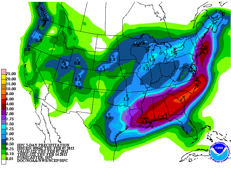
Now we look ahead, from days to months, to see what the forecasters have in
mind for us. The latest 7-day rain forecast from the HPC has Oklahoma painted
some delicious shades of green and blue, so about a tenth of an inch in the
Panhandle to more than an inch in the east.
http://ticker.mesonet.org/archive/20130207/7day-rain.gif
Not too shabby! We really do need to transfer some of those larger amounts
to the west, however. If we go out a bit further, we can see from the 8-14 day
CPC Outlooks that we have increased odds of normal ("N") precipitation amounts
and below normal temperatures over that Feb. 14-20 time frame.
http://ticker.mesonet.org/archive/20130207/814prcp.new.gif
http://ticker.mesonet.org/archive/20130207/814temp.new.gif
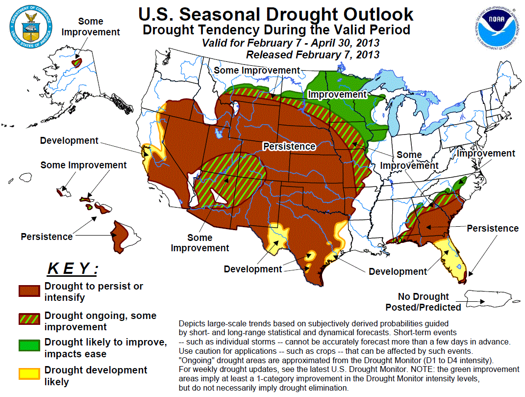
Now for the not-so-rosy news. The U.S. Seasonal Drought Outlook this morning
didn't improve over the map released two weeks ago, at least for Oklahoma.
The CPC forecasters still have Oklahoma in that "drought persisting or
intensifying" area through the end of April.
http://ticker.mesonet.org/archive/20130207/season_drought.gif
If you look at their reasoning, they acknowledge the moisture in the short-term,
but they see drier conditions over the long term. Here it is in their words:
"Widespread precipitation during late December and early January was
replaced by much drier conditions since mid-month, halting drought
improvement in Texas and actually producing some deterioration in
central sections. Precipitation is expected to return during the next
week, but be mainly confined to eastern sections. Then, the CPC 6-10
and 8-14 day outlooks tilt the odds in favor of above median
precipitation in southern and eastern areas. However, the CPC (Feb-Apr)
outlooks and the (forecast) models all indicate enhanced chances of
below median precipitation for the southern Plains, with the updated
monthly precipitation outlook indicating subnormal precipitation along
the Gulf and equal chances elsewhere. Monthly and seasonal temperatures
strongly tilt toward above normal values. Although short-term forecasts
indicate rainfall to return, the longer-term guidance points to overall
drier conditions. Accordingly, although some short-term improvements
may occur in Texas during mid to late February, drought should persist
or redevelop in Texas and the southern Plains later in the period,
except in extreme eastern Texas. Forecast confidence for the southern
Plains is moderate."
So in their view, some short-term improvements will occur (with the coming
rain), but drought will persist or redevelop as we get later into the spring.
Always remember, these outlooks are not perfect. But they're the best the
science has to offer. There is always hope we can change things around and
knock this drought out of here.
Gary McManus
Associate State Climatologist
Oklahoma Climatological Survey
(405) 325-2253
gmcmanus@mesonet.org
==================================================
The OCS/Mesonet Ticker
https://ticker.mesonet.org/
To subscribe or unsubscribe from the Ticker
or for questions about the Ticker or its content
Phone or Email the Ticker Manager at OCS
Phone: 405-325-2253 Email: ticker@mesonet.org
---------------------------------------------------
-C- Copyright 2024 Oklahoma Climatological Survey
===================================================
|


 Tweet
Tweet