MESONET TICKER ... MESONET TICKER ... MESONET TICKER ... MESONET TICKER ...
January 13, 2016 January 13, 2016 January 13, 2016 January 13, 2016
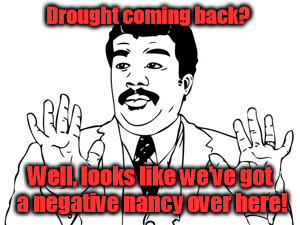
El Nino has peaked...is La Nina next?
http://ticker.mesonet.org/archive/20160113/drought.jpg
This is going to seem like a Chicken Little post, especially since just yesterday
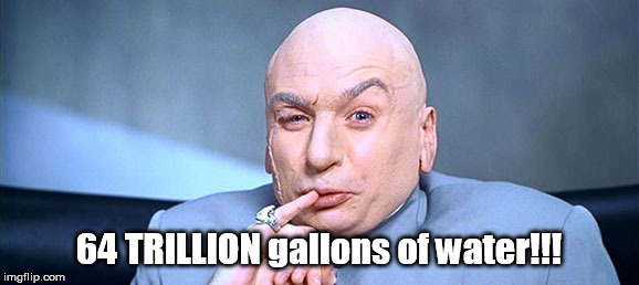
we said that 64 million...ahem...
64 *TRILLION* gallons of water fell on the state during 2015.
http://ticker.mesonet.org/archive/20160112/dr-evil.jpg
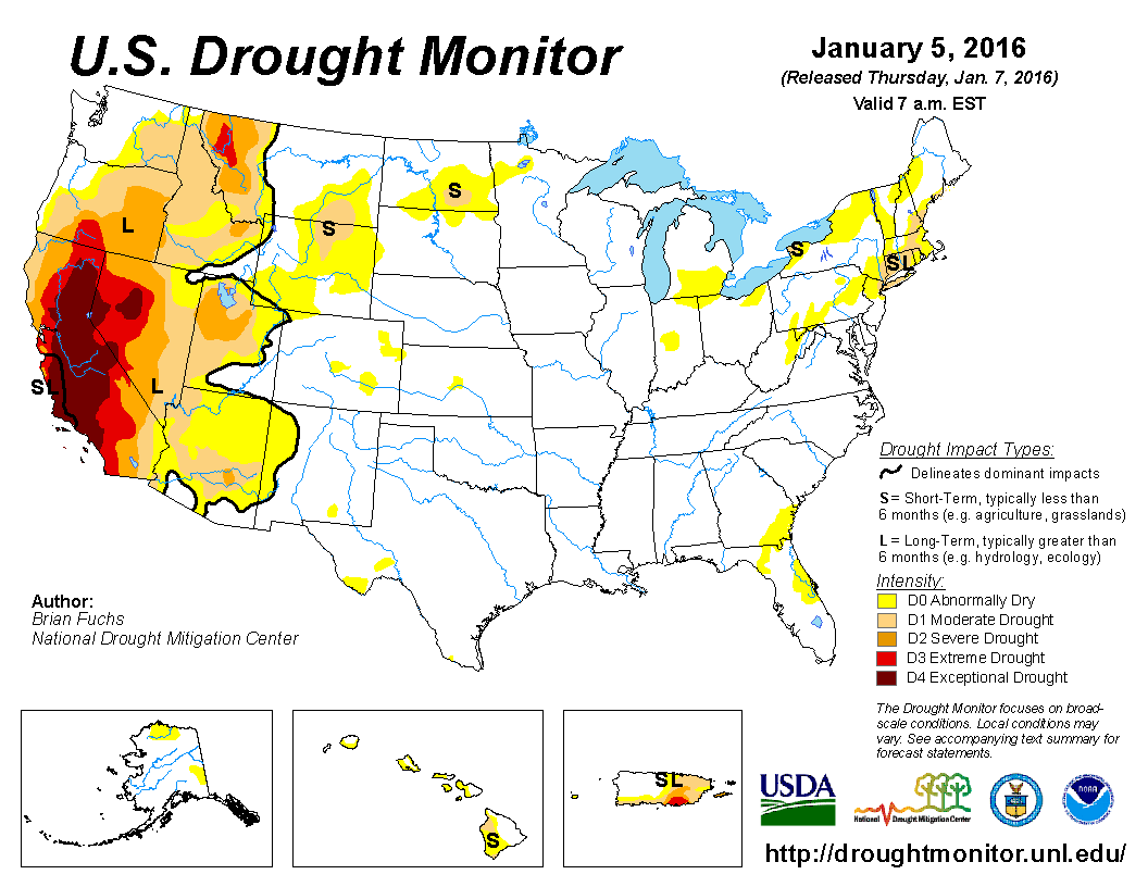
And drought has indeed been extinguished across not only Oklahoma, but most of the
eastern 2/3rds of the U.S.
http://ticker.mesonet.org/archive/20160113/20160105_usdm_home.png
But now that more and more experts are claiming that the current 2015-16 El Nino
has peaked, and will now start to fade into "neutral conditions" as we go through
spring into summer, what comes next? The impacts of the still very strong El Nino
are expected to continue through the spring, at least early spring. And as the
person in the state tasked each week with consolidating all the possible drought
information available from the myriad (AND I MEAN MYRIAD, NOT THE COX CONVENTION
CENTER) sources to feed into the U.S. Drought Monitor effort, I feel confident
that we should not have to worry about drought re-entering our thoughts for the
next several months. And I like having that extra 5-10 hours from Sunday-Tuesday
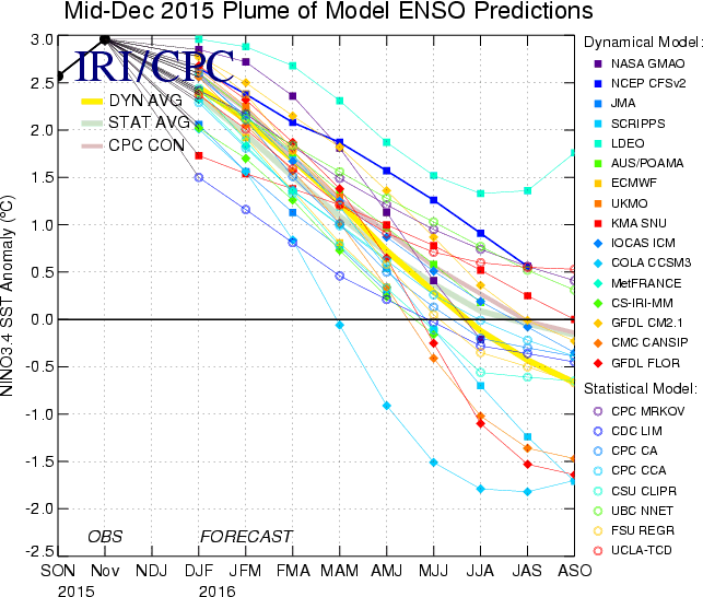
to work on other things! Before we go on, we'll take one more look at the last
ENSO prediction plume from IRI/CPC. Remember, anything above 0.5C is considered
El Nino territory, between +0.5C and -0.5C is "neutral conditions," and below
-0.5C would be La Nina.
http://ticker.mesonet.org/archive/20160113/mid-december-ENSO-plume.gif
Buttttttt, you're probably going to be hearing more and more about this, so
I'll just go ahead and throw it out there. You're seeing some of those model
runs starting to take the equatorial pacific into La Nina as we get into next
fall. Other experts note that the chance for La Nina is even more pronounced
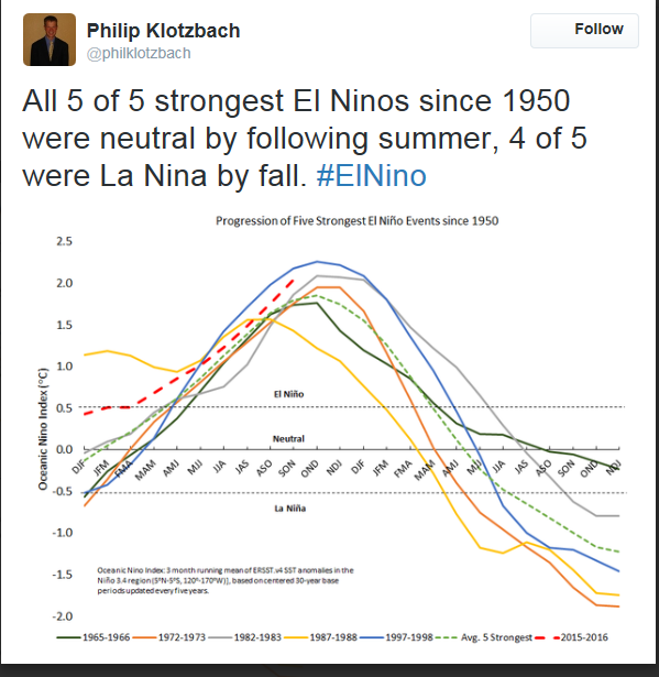
after these so-called "super El Ninos." For instance, this tweet by Philip
Klotzbach, an expert in tropical meteorology from Colorado State University,
notes that all of the strongest El Ninos since 1950 (1965-66, 1972-73, 1982-83,
1997-98) were neutral by the following summer, and 4 of those 5 (the latter 4
listed above) were La Nina by fall.
http://ticker.mesonet.org/archive/20160113/ElNino-to-LaNina.png
You can and probably will see many other variants of this type of graph, using
other indexes and measures, saying sort of the same thing over the next few
months. I won't overload you too much, but just know that those forecast plumes
and analogs like I just showed you are certainly not locked in or guarantees.
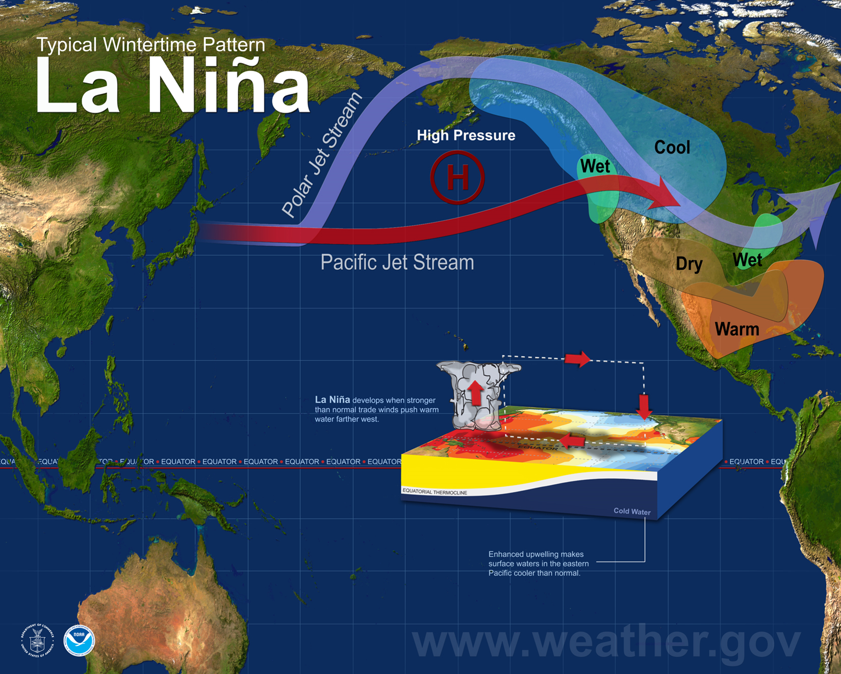
However, it is important to note since La Nina is definitely not our friend.
Remember its impacts on us, which are unfavorable.
http://ticker.mesonet.org/archive/20160113/la-nina-impacts.png
La Nina was partially responsible for the beginning of our 2010-15 drought, and
also the misery to agriculture through that horrible 2010-12 period when so much
damaging heat and dry weather occurred.
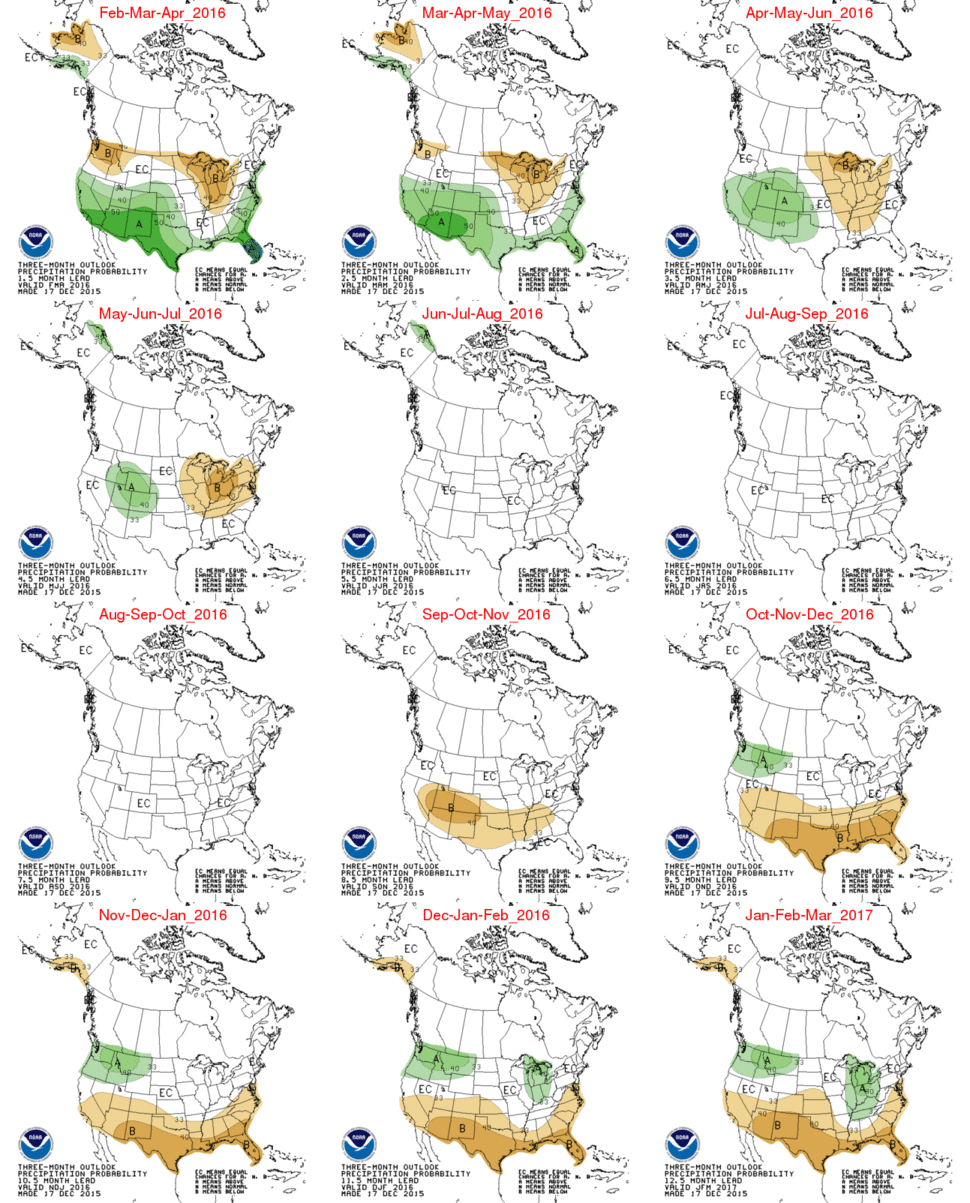
And the seasonal outlooks for next fall and winter, very much a fantasy-cast
at this point, are already pointing towards that possibility of La Nina and
its impacts. Notice in this one large collection how they transform from
increased odds of above normal precip for the rest of this winter and spring
into drier than normal weather next fall and winter.
http://ticker.mesonet.org/archive/20160113/three-month-precip-outlooks.gif
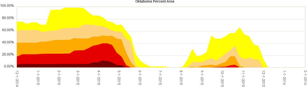
And let's not forget that even between the monumentally wet spring/summer of
and November/December of 2015, drought still made a comeback across the state.
http://ticker.mesonet.org/archive/20160113/2015-OK-drought.png
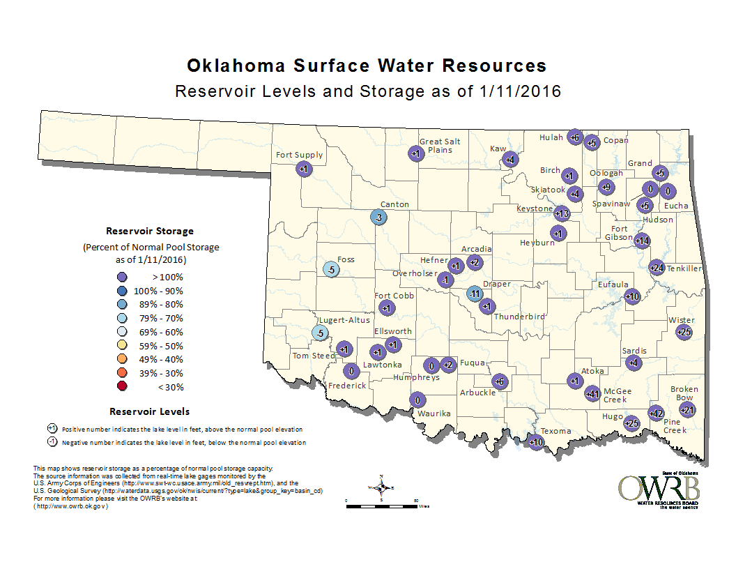
Things are looking wonderful now. Most of our lakes are full, heck...brimming
over still in the east.
http://ticker.mesonet.org/archive/20160113/MonthlyReservoirStorage.png
Soil moisture, solid.
http://www.mesonet.org/index.php/weather/category/soil_moisture
So I guess the message here, in the common and crass vernacular of my Panhandle
upbringing, is "let's not get cocky." After what we saw over the last five years,
conservation and good practices should be a permanent part of our water use
and planning.
Hey, don't take it from me. Take it from somebody of much more import:
https://www.youtube.com/watch?v=N0nyOyrprIs
Gary McManus
State Climatologist
Oklahoma Mesonet
Oklahoma Climatological Survey
(405) 325-2253
gmcmanus@mesonet.org
==================================================
The OCS/Mesonet Ticker
https://ticker.mesonet.org/
To subscribe or unsubscribe from the Ticker
or for questions about the Ticker or its content
Phone or Email the Ticker Manager at OCS
Phone: 405-325-2253 Email: ticker@mesonet.org
---------------------------------------------------
-C- Copyright 2024 Oklahoma Climatological Survey
===================================================
|


 Tweet
Tweet