MESONET TICKER ... MESONET TICKER ... MESONET TICKER ... MESONET TICKER ...
January 2, 2018 January 2, 2018 January 2, 2018 January 2, 2018
What a month, what a year?
It's cold, okay? And you regular Ticker readers know how I feel about that. You
irregular readers (you know who you are...or do you?) should know this: I hate
winter. I hate cold. I hate hating winter. I wish I could embrace it, but we've
had so little of it lately, what's the point? Well, here's the point. If I loved
it, this wouldn't look so bad!
http://ticker.mesonet.org/archive/20180102/momentous.png
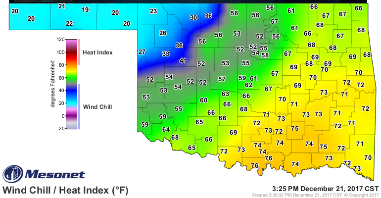
Whoa whoa WHOA!! Wait just a minute, ladies and gentlemen. Correct me if'n I'm
wrong, but that's a 36 at Kenton. 32 is freezing. 36 > 32. Wait a minute.
KENTON IS ABOVE FREEZING!! Oh happy happy joy joy, once again I live my life
vicariously through the Panhandle. I'm so happy I going to go right ahead and
get right to the summary, before I numb your mind like mine.
---------------------------------------------------------------------------------
Arctic Invasion Dominates December
Jan. 2, 2018
Oklahoma?s seemingly endless supply of mild weather came to an abrupt halt
during the third week of December, ushering in a frigid end to a warm 2017. A
bulge in the jet stream allowed frosty air to plunge southward and place most
of the country into an arctic deep freeze. Oklahoma?s introduction to the cold
air came on Dec. 21
http://ticker.mesonet.org/archive/20180102/dec21-cold.front.png
and lasted through the end of the year. Highs in the 60s and even a few 70s were
common during the first three weeks of December, topped by a high of 83 degrees
at three Mesonet sites in southwest Oklahoma on the fourth. Following the
arctic front on the 21st, much of the state endured more than 150 hours at or
below freezing through the rest of December, topped by Beaver and Slapout?s 216
hours.
http://ticker.mesonet.org/archive/20180102/hours-below-freezing.dec21-dec31.png
Mother Nature saved the coldest air for December?s final day with temperatures
dipping into the single digits and wind chills of minus 10 degrees or lower
across northern Oklahoma. The month?s lowest temperature of zero degrees was
recorded at the Eva Mesonet site on the 31st. With the cold air in place, small
storm systems brought bouts of occasional wintry weather in its usual forms.
Sporadic stretches of light snow provided joy to some, while freezing drizzle
caused travel problems for others. Despite the chilly end, December was warm
for the most part. According to preliminary data from the Oklahoma Mesonet, the
month finished above normal by about a degree with a statewide average of 39.8
degrees. Those records date back to 1895.
http://ticker.mesonet.org/archive/20180102/dec-avg-temp.png
http://ticker.mesonet.org/archive/20180102/dec-temps-depart.png
The dry weather that had plagued the state since early October continued
through December. Of the 120 Mesonet sites, five in northwestern Oklahoma
received no moisture for the month, and an additional 39 recorded a quarter-inch
or less.
http://ticker.mesonet.org/archive/20180102/dec-rain-totals.png
http://ticker.mesonet.org/archive/20180102/dec-rain-depart.png
http://ticker.mesonet.org/archive/20180102/dec-rain-pct.png
The Mesonet site at Beaver had not recorded a drop of precipitation for 85
consecutive days as of Dec. 31, dating back to Oct. 7.
http://ticker.mesonet.org/archive/20180102/mesonet.rainfall.tenthinch.png
http://ticker.mesonet.org/archive/20180102/mesonet.rainfall.quarterinch.png
Several storm systems managed to squeeze out significant moisture across far
southeastern Oklahoma. Eleven stations in the southeast recorded at least 3
inches of rain, with Valliant leading the way at 5.65 inches. Unfortunately,
the totals dropped rapidly to the northwest leaving approximately 90 percent of
the state below normal for the month. The snowfall was light for the most part,
although the Tulsa area accumulated as much as 2.5 inches on the 23rd.
Drought increased at an unusually rapid pace during December, when evaporation
and consumption are diminished. The extended dearth of precipitation began to
cause significant harm to Oklahoma?s wheat and cattle industry, however. The
percentage of drought coverage in the state increased from 40 percent in late
November to 76 percent at the end of December according to the U.S. Drought
Monitor. Most of that increase occurred across southern and western Oklahoma.
The drought intensity was lessened across far southeastern Oklahoma thanks to
the beneficial rains, although the area remained in drought. The percentage of
the state in drought at the end of December was the most since late March.
http://ticker.mesonet.org/archive/20180102/nov28.drought.monitor.png
http://ticker.mesonet.org/archive/20180102/dec26-drought.monitor.png
Although the statistics paint 2017 as a warm and wet year, the shorter time
scales portray Oklahoma?s normal highly variable climate. According to
preliminary data from the Oklahoma Mesonet, the year was the 13th warmest since
records began in 1895 with a statewide average of 61.8 degrees, 1.8 degrees
above normal.
http://ticker.mesonet.org/archive/20180102/2017-avg-temps.png
http://ticker.mesonet.org/archive/20180102/2017-temps-departure.png
The highest temperature recorded by the Mesonet in 2017 was 108 degrees at
Kingfisher on July 22, although the heat index calculated at Copan was 115
degrees that same day. The lowest reading of minus 19 degrees came at Kenton on
Jan. 7. On that same day, the wind chill calculated at Hooker bottomed out at
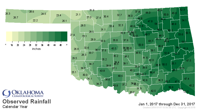
minus 28 degrees. 2017 also ranked as the 29th wettest year on record at 2.02
inches above normal with a statewide average of 38.52 inches.
http://ticker.mesonet.org/archive/20180102/2017-rain-totals.png
http://ticker.mesonet.org/archive/20180102/2017-rain-pct.png
http://ticker.mesonet.org/archive/20180102/2017-rain-depart.png
That rain came in fits and spurts, however. Extended dry stretches occurred
during February-March, June-July, and again during the final three months of
the year. April and August were both exceedingly wet, ranking as the third and
second wettest on record for those particular months, respectively. November
ranked as the fifth driest on record. Hugo led the Mesonet with 56.9 inches of
rain for the year. Buffalo had the lowest total at 21.1 inches. The National
Weather Service?s preliminary tornado count of 86 was well above the 1950-2016
average of 56. May was the big twister month with 57 reported touchdowns,
including a deadly EF2 tornado in Beckham and Washita counties that resulted in
one fatality. An EF2 tornado injured 30 and caused significant damage to
businesses in the midtown Tulsa area on Aug. 6.
The precipitation and temperature outlooks for January from the Climate
Prediction Center (CPC) indicate increased odds of below normal temperatures
and above normal precipitation across eastern Oklahoma. No clear signal was
apparent for the remainder of the state.
http://ticker.mesonet.org/archive/20180102/jan-temp-outlook.gif
http://ticker.mesonet.org/archive/20180102/jan-precip-outlook.gif
The CPC January-March outlooks released on December 21 show increased odds for
above normal temperatures and below normal precipitation across the entire
state, but especially across western Oklahoma.
http://ticker.mesonet.org/archive/20180102/jan-march-temp-outlook.gif
http://ticker.mesonet.org/archive/20180102/jan-march-precip-outlook.gif
The January Drought Outlook from CPC calls for either persistence or
intensification within the drought stricken areas across the western two-thirds
of the state. Far eastern Oklahoma could see improvement or even drought
removal by the end of the month.
http://ticker.mesonet.org/archive/20180102/january-drought-outlook.png
La Ni?a ? the cooling of waters in the eastern equatorial Pacific Ocean that
tilts the odds for warmer and drier cool seasons across the southern tier of
the United States ? is expected to continue through mid-to-late spring
according to the most recent CPC advisory.
http://ticker.mesonet.org/archive/20180102/ENSO-forecast.png
Gary McManus
State Climatologist
Oklahoma Mesonet
Oklahoma Climatological Survey
(405) 325-2253
gmcmanus@mesonet.org
==================================================
The OCS/Mesonet Ticker
https://ticker.mesonet.org/
To subscribe or unsubscribe from the Ticker
or for questions about the Ticker or its content
Phone or Email the Ticker Manager at OCS
Phone: 405-325-2253 Email: ticker@mesonet.org
---------------------------------------------------
-C- Copyright 2024 Oklahoma Climatological Survey
===================================================
|


 Tweet
Tweet