MESONET TICKER ... MESONET TICKER ... MESONET TICKER ... MESONET TICKER ...
July 31, 2012 July 31, 2012 July 31, 2012 July 31, 2012
CPC outlooks for August are less than promising
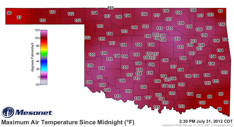
Speaking of little promise, today's high temperature map from the Mesonet is
looking particularly nasty, even in the early afternoon.
http://ticker.mesonet.org/archive/20120731/today.TAIR.max.grad.png
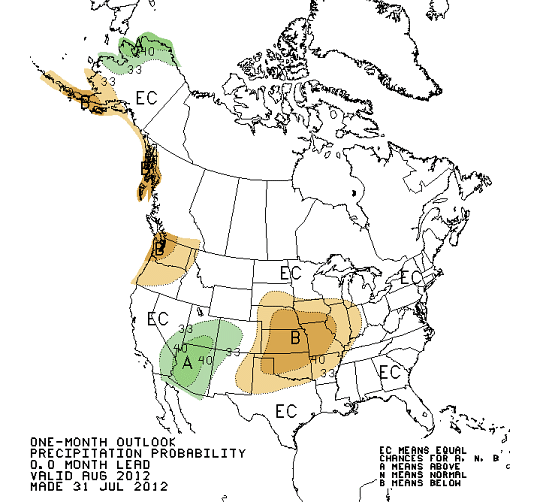
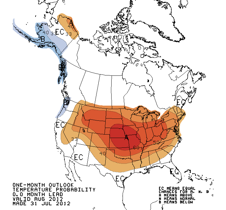
The outlooks for August were just released by the NWS' Climate Prediction Center
(*Warning, the following images depict scenes of violence, and horror). I'm
afraid they show increased odds of more of the same for Oklahoma and much of the
central U.S.
http://ticker.mesonet.org/archive/20120731/august-precip.gif
http://ticker.mesonet.org/archive/20120731/august-temps.gif
For a quick primer ... the "A" depicts increased odds of above normal temperatures
or precipitation. Likewise, the "B" depicts increased odds of below normal
temperatures or precipitation. Oklahoma is obviously in the increased odds of
below normal precip and above normal temps. No shocker there, really. Here is
the CPC reasoning for both (their screaming, not mine).
"THE UPDATED AUGUST 2012 TEMPERATURE OUTLOOK DEPICTS ENHANCED ODDS FOR
ABOVE-NORMAL MEAN TEMPERATURES ACROSS MOST OF THE CONTIGUOUS UNITED STATES AND
NORTHERN ALASKA. THIS IS BASED ON CONSISTENT SIGNATURES FROM CLIMATE MODEL
FORECASTS (CFSV2 AND NMME), VERY LOW SOIL MOISTURE CONDITIONS ACROSS THE
EAST-CENTRAL CONUS, LONG TERM TEMPERATURE TRENDS, AND TEMPERATURE OBSERVATIONS
OVER THE PAST 30-DAYS. THE LARGEST PROBABILITIES ARE INDICATED OVER THE MIDDLE
MISSISSIPPI VALLEY AND ADJACENT PORTIONS OF THE CENTRAL PLAINS, WHICH HAVE VERY
LOW SOIL MOISTURE VALUES AND SEVERE REDUCTIONS IN EVAPOTRANSPIRATION, BOTH OF
WHICH CAN RESULT IN PERPETUATING THE REGIONAL DROUGHT."
Translation: Drought begets heat during the summer, and August is not the time
to look for relief.
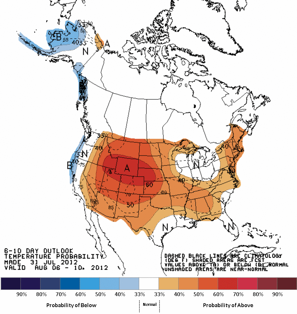
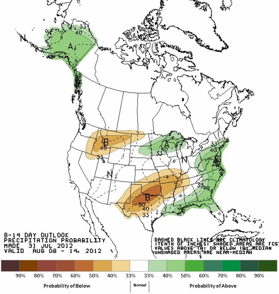
The medium-term outlooks for August 6-14 show pretty much the same thing.
6-10 Day CPC Outlooks (Aug 6-10)
http://ticker.mesonet.org/archive/20120731/610prcp.new.gif
http://ticker.mesonet.org/archive/20120731/610temp.new.gif
8-14 Day CPC Outlooks (Aug 8-14)
http://ticker.mesonet.org/archive/20120731/814prcp.new.gif
http://ticker.mesonet.org/archive/20120731/814temp.new.gif
Even larger translation: the drought will get worse, possibly much worse, before
it gets better. Let's hope for a pattern change. It can happen.
--------------------------------------------------------------------------------
Sneak peek for final July stats
Just as I thought, July 2012 zoomed up the record books with its final two days
of heat, and is now ranked as the sixth warmest July on record at 85.9 degrees.
That's 4.3 degrees above normal. This is still preliminary until we reach our
final high temperatures later today. The month will also finish at approximately
1.63 inches below normal with a statewide average of 1.11 inches, the 15th
driest on record. Obviously, we've had some REALLY dry Julys in our past.
Ten of the Mesonet's 120 stations will finish with less than a tenth of an
inch of rainfall for the month, and 54 had less than a half of an inch. Here
are your low 10:
-****-
Spencer 0.00"
Waurika 0.00"
Marshall 0.00"
Norman 0.02"
Hollis 0.03"
Vinita 0.05"
Butler 0.06"
Copan 0.07"
Stillwater 0.07"
Lake Carl Blackwell 0.08"
-***-
Two summers in a row ... string a few more in a row and we'll know what the
summers of the 1930s and 1950s felt like. Let's hope the 2010s don't become
famous.
Gary McManus
Associate State Climatologist
Oklahoma Climatological Survey
(405) 325-2253
==================================================
The OCS/Mesonet Ticker
https://ticker.mesonet.org/
To subscribe or unsubscribe from the Ticker
or for questions about the Ticker or its content
Phone or Email the Ticker Manager at OCS
Phone: 405-325-2253 Email: ticker@mesonet.org
---------------------------------------------------
-C- Copyright 2024 Oklahoma Climatological Survey
===================================================
|


 Tweet
Tweet