MESONET TICKER ... MESONET TICKER ... MESONET TICKER ... MESONET TICKER ...
July 30, 2020 July 30, 2020 July 30, 2020 July 30, 2020
What a wonderful July?
http://ticker.mesonet.org/archive/20200730/july-rain-pct-normal.png
The alarm bells were sounded at the end of June: you don't want a drought in place
headed into the depths of summer (i.e., July and August). I know of said bells,
because I was the one ringing them. That alone was enough to end up with an
eggstremely (egg on my face reference...work with me) wet July in the hardest hit
parts of the state. Yes, Mother Nature spites me like that.
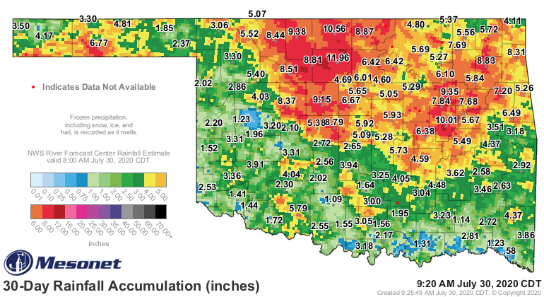
http://ticker.mesonet.org/archive/20200730/30day-rain-totals.png
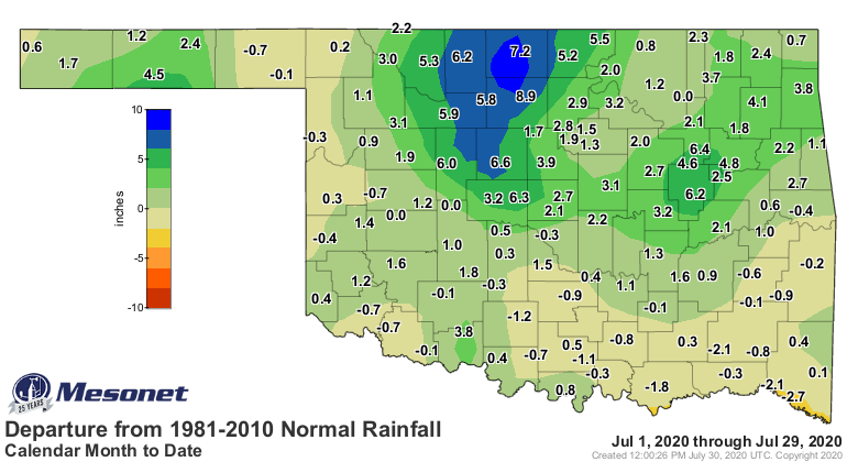
http://ticker.mesonet.org/archive/20200730/july-rain-departure.png
Not too shabby. Yes, there are definitely some that got too much, and the ensuing
flooding was not welcomed. And others didn't get enough, and the current Drought
Monitor map reflects that.
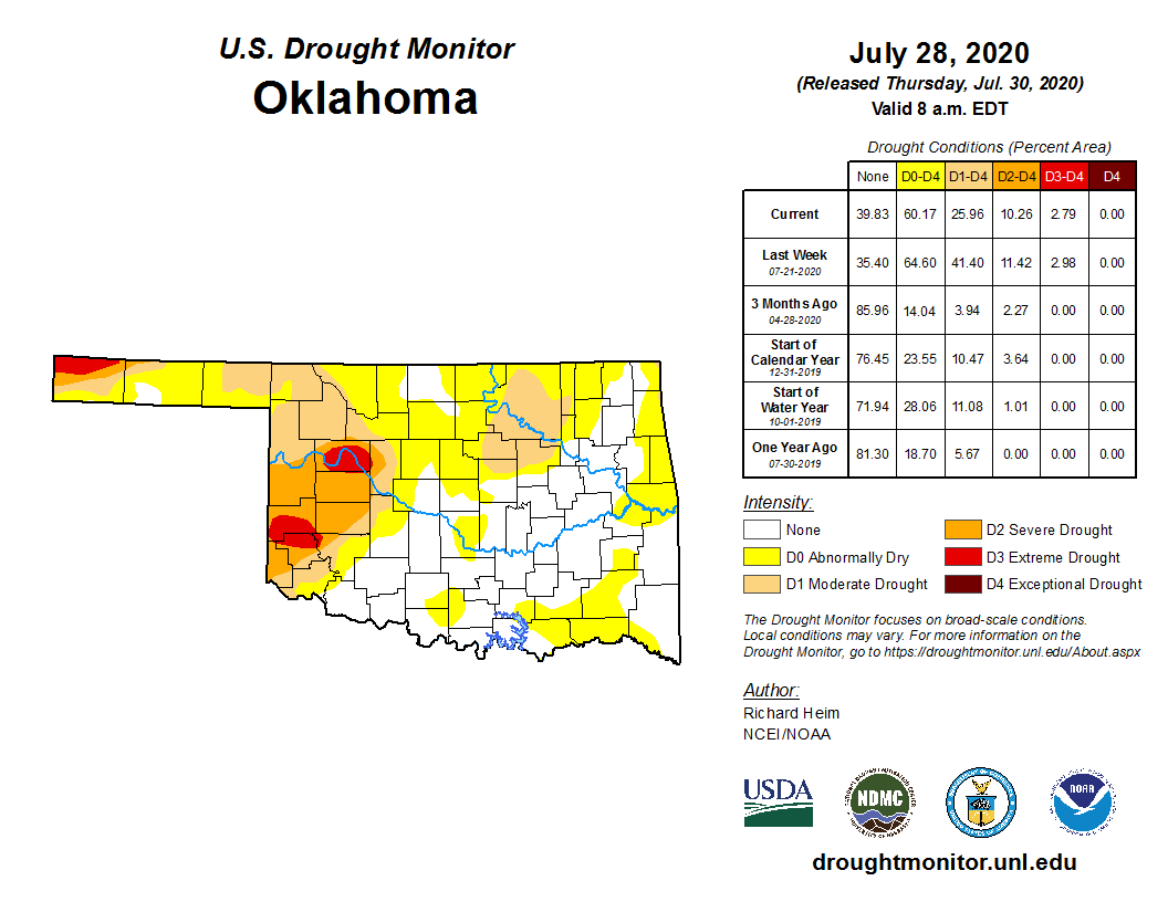
http://ticker.mesonet.org/archive/20200730/20200728_OK_trd.png
The 26% of the state still in drought is way too much, but just look at the
changes we've seen since the end of June.
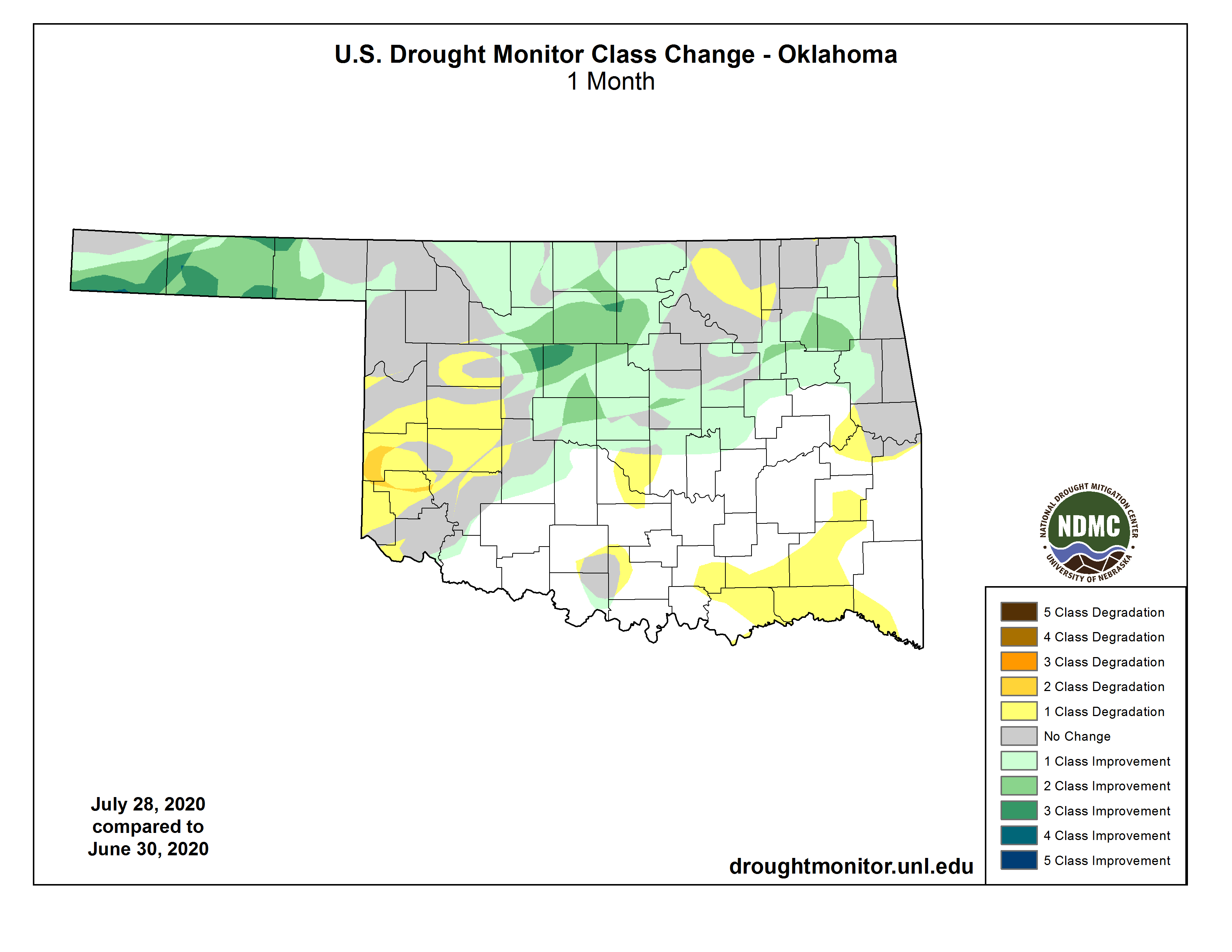
http://ticker.mesonet.org/archive/20200730/June30-July28-DM-changes.png
The unfortunate part is the addition of the drought in southwestern Oklahoma,
but the improvements in the Panhandle come after nearly 9 months of tough
drought conditions. And north central Oklahoma was headed for some really bad
fortunes staring July in the face with a flash drought continuing to intensify
rapidly. It wasn't that long ago that places like Watonga and Kingfisher were
seeing record low rainfall amounts from April forward.
Now here's some better news. The rain isn't done with us yet. We have a few more
days of rain chances, extending into early next week. Today could be a soaker
across much of the main body of the state. Trouble is, some of that more
turbulent weather might come with it. It's Oklahoma. It's expected.
http://ticker.mesonet.org/archive/20200730/day1otlk_1300.gif
http://ticker.mesonet.org/archive/20200730/day1probotlk_1300_wind.gif
http://ticker.mesonet.org/archive/20200730/day1probotlk_1300_hail.gif
That ain't much. Of course, if the severe stuff hits where you live, then it IS
much. But you know what I mean. So we'll hope some of this rain on the 7-day
precip forecast shifts to the south and west, because south central and
southwestern Oklahoma are in danger of seeing drought proliferate without
appreciable moisture soon.
http://ticker.mesonet.org/archive/20200730/7day-rain-forecast.gif
One thing working in their favor is the much cooler air that has spread over
the region, reducing the pressure on the soil moisture and surface water
supplies, which by itself can reduce the dangers of flash drought.
After that, it looks dry again but still cool.
http://ticker.mesonet.org/archive/20200730/aug4-8-temp-outlook.gif
http://ticker.mesonet.org/archive/20200730/aug4-8-precip-outlook.gif
This will be a test of Mother Nature's spitefulness towards me. I guess we'll
get ready for an extremely wet first week of August, with sweltering
temperatures!
Gary McManus
State Climatologist
Oklahoma Mesonet
Oklahoma Climatological Survey
(405) 325-2253
gmcmanus@mesonet.org
==================================================
The OCS/Mesonet Ticker
https://ticker.mesonet.org/
To subscribe or unsubscribe from the Ticker
or for questions about the Ticker or its content
Phone or Email the Ticker Manager at OCS
Phone: 405-325-2253 Email: ticker@mesonet.org
---------------------------------------------------
-C- Copyright 2024 Oklahoma Climatological Survey
===================================================
|


 Tweet
Tweet