MESONET TICKER ... MESONET TICKER ... MESONET TICKER ... MESONET TICKER ...
August 29, 2012 August 29, 2012 August 29, 2012 August 29, 2012
Round and round he goes!
Who knew Isaac was such a big fan of 1970s cheap plastic toys? Apparently,
somebody gave him a Sit 'n Spin for his birthday. And I'm not talking about the
cheap Hasbro version kids have today, with pictures of Dora or some other lesser
cartoon character. I'm referring to the Kenner version that could hold three
people and a dog!
http://ticker.mesonet.org/archive/20120829/sitnspin.jpg
But that is exactly the toy Isaac appears to be playing with as he spins off
the Louisiana coast, bringing wave after wave of torrential rainfall to that area
of the Gulf. We certainly feel for those folks, but we would love to get some
of that moisture up our way to quell our still-raging drought. The fact that
Isaac has been so indecisive thus far is another reason for hope that we might
actually get a brush from Isaac's moisture, especially across eastern Oklahoma.
The latest official forecast track from the NWS' National Hurricane Center still
has eastern Oklahoma in it's probable path cone with Isaac a tropical depression
at that point. Arkansas is still their best bet, however.
http://ticker.mesonet.org/archive/20120829/AL0912W5.gif
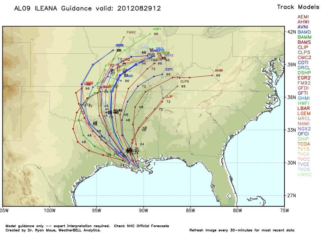
Several of the model tracks still have Oklahoma in the realm of possibilities.
http://ticker.mesonet.org/archive/20120829/AL09_current.png
Now the NHC can see all of these models as well, and they know more about
the comings and goings of tropical systems than this humble Associate State
Climatologist (I bet I know more about 1970s plastic toys, though!). Here is
their reasoning for their forecast track. NOAA loves to yell, by the way.
"SINCE THE SYSTEM HAS ONLY BEGUN TO MOVE RECENTLY...THE INITIAL
MOTION IS AN UNCERTAIN. ISAAC IS CURRENTLY MOVING THROUGH A
WEAKNESS IN THE SUBTROPICAL RIDGE. OVER THE NEXT FEW DAYS...A
MID-LEVEL (high pressure system) SHIFTS EASTWARD OVER THE CENTRAL
AND EASTERN UNITED STATES. AS A RESULT...ISAAC SHOULD GRADUALLY TURN
TOWARD THE NORTH AND NORTHEAST DURING THE FORECAST PERIOD. NEAR THE
END OF THE PERIOD...POST-TROPICAL ISAAC SHOULD MOVE EAST-NORTHEASTWARD
IN THE FLOW BETWEEN THE MID-LATITUDE WESTERLIES AND THE AFOREMENTIONED
ANTICYLONE. THE OFFICIAL TRACK FORECAST IS SIMILAR TO THE PREVIOUS
ONE AND CLOSE TO THE MODEL CONSENSUS."
So still a bit tenuous, although we can't just extrapolate Isaac's recent
uncertainty into the future. Eventually he will have to move where the
atmosphere allows. It makes it a bit more complicated since he is part of that
atmosphere. We shouldn't think of him as some sort of solid object moving through
a stream. More like a disturbed part of water, maybe.
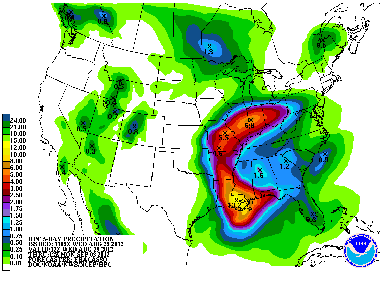
The latest 5-day rainfall forecast from the NWS' HPC gives eastern Oklahoma a
bit of a bath thanks to Isaac.
http://ticker.mesonet.org/archive/20120829/5-day-rain.gif
Again, that's based on Isaac's favored track from the NHC (if we can get the
CIA, the NSA and the FBI involved, we can almost have an alphabet!). Any shift
to the west and that brings eastern Oklahoma into the 2-4 inch range, up from
the 0.5-1.0 inch range they're in now.
For Oklahoma in general, it's back into the frying pan. A ridge of high
pressure builds back over the state and finds it's old friend drought still
hanging around, the perfect ingredients for hot weather. Watch for highs to
approach 100 degrees across the state by this weekend.
http://ticker.mesonet.org/archive/20120829/sunday-NWS-forecast.png
By the way, everybody knows the Big Wheel was far superior to the Sit 'n Spin.
Would you rather stay in one place and get dizzy, or careen down a hill at 20
mph on a cheap plastic frame with pedals spinning at an incredible skin-scraping
speed near your feet?
Roaring! Spinning! Winning!
http://www.youtube.com/watch?v=HjTAA_da97w&feature=player_embedded
Kids from the rich side of town got a Green Machine. Those that were not into
speed or dizziness just asked for a Stretch Armstrong. There's one in every
bunch.
Gary McManus
Associate State Climatologist
Oklahoma Climatological Survey
(405) 325-2253
gmcmanus@mesonet.org
==================================================
The OCS/Mesonet Ticker
https://ticker.mesonet.org/
To subscribe or unsubscribe from the Ticker
or for questions about the Ticker or its content
Phone or Email the Ticker Manager at OCS
Phone: 405-325-2253 Email: ticker@mesonet.org
---------------------------------------------------
-C- Copyright 2024 Oklahoma Climatological Survey
===================================================
|


 Tweet
Tweet