MESONET TICKER ... MESONET TICKER ... MESONET TICKER ... MESONET TICKER ...
August 27, 2020 August 27, 2020 August 27, 2020 August 27, 2020
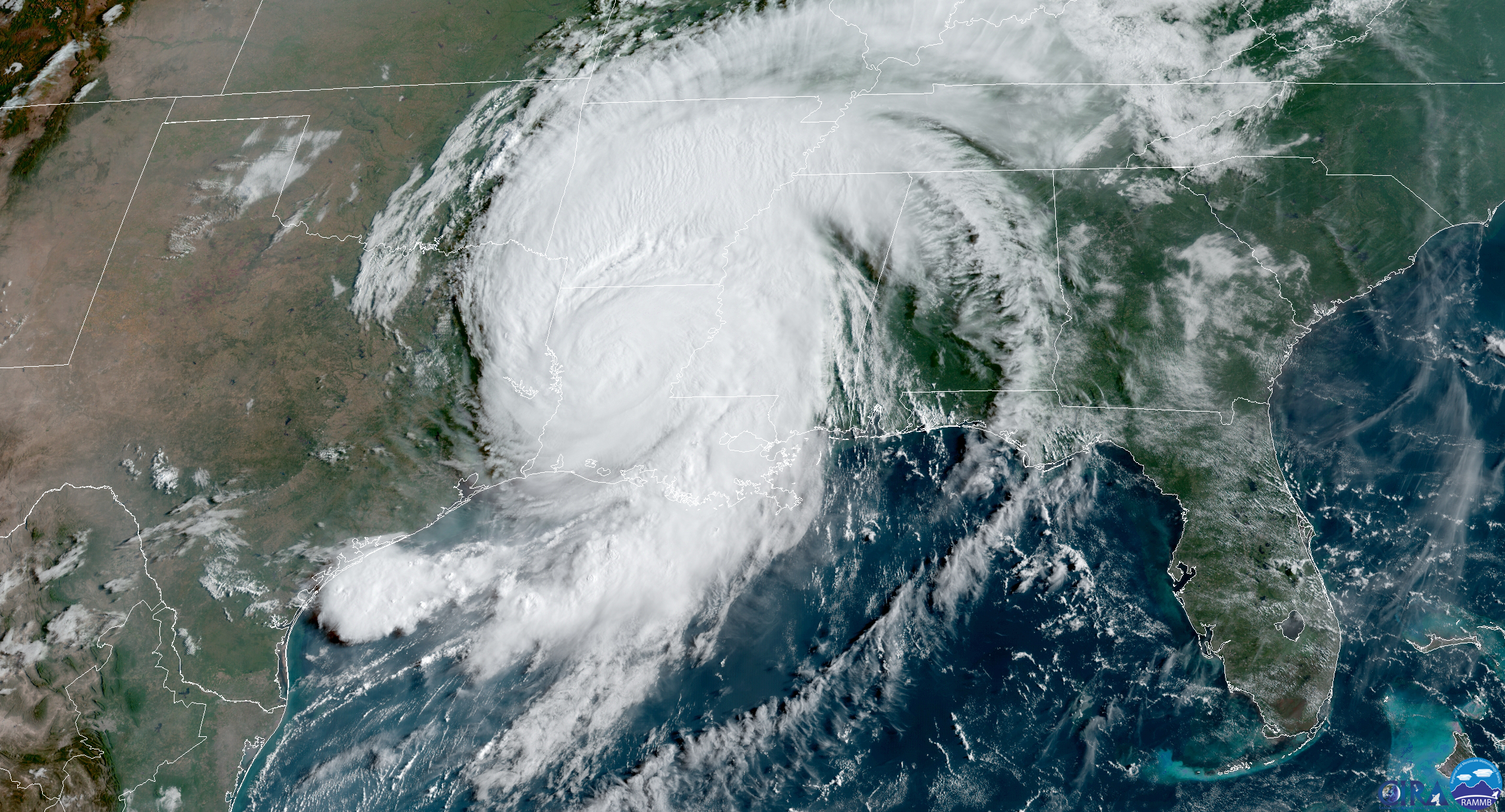
800-pound hurricane
http://ticker.mesonet.org/archive/20200827/laura.png
Well, we might as well lead with the 800-pound hurricane in the room, as Laura
slammed ashore last night as a monster Cat-4 storm. The damage from the
wind and associated storm surge was catastrophic, as could be expected. For our
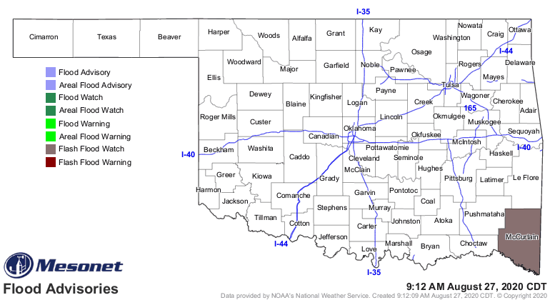
weather, the fringe counties along our border with Arkansas will be affected
throughout today, with McCurtain County feeling the worst our state will see. That
county will continue in a flash flood watch and high wind warning until Laura
passes to the northeast and pulls her impacts with her.
http://ticker.mesonet.org/archive/20200827/latest.oklahoma.flood.gif
http://ticker.mesonet.org/archive/20200827/latest.oklahoma.winds.gif
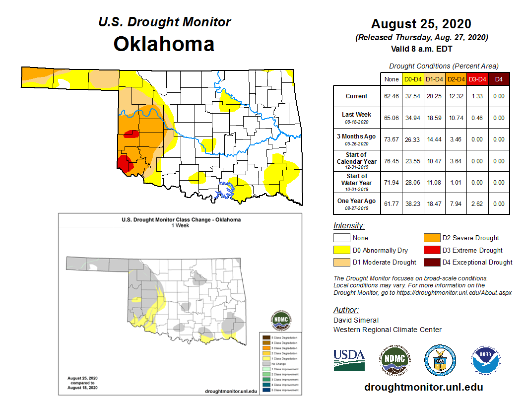
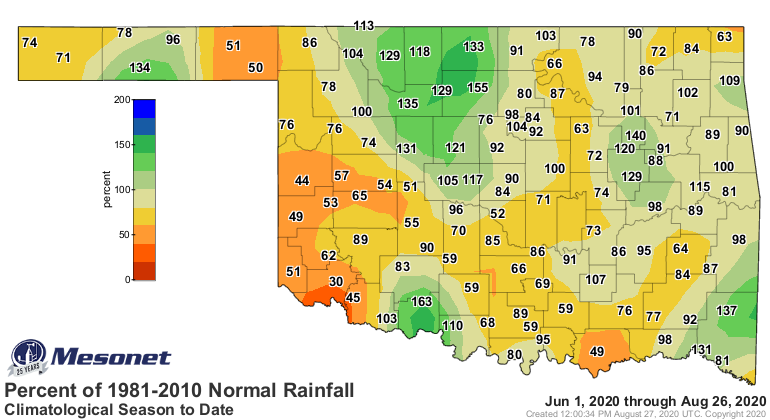
Farther to the west, our old nemesis -- drought -- is starting to flare up
once again. Fueled by another dry week and high temperatures, we now see
extreme drought once again spreading in far southwest and up into west central
Oklahoma. In fact, this is the first week we haven't seen some decent
improvements in some part of the state.
http://ticker.mesonet.org/archive/20200827/20200825_OK_trd.png
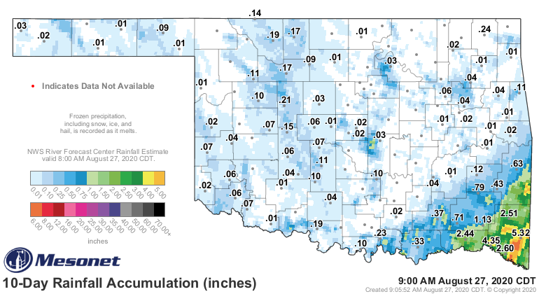
The rains over the last week, save for far southeastern OK, were spotty at
best, and lesser at least.
http://ticker.mesonet.org/archive/20200827/10day-rain-totals.png
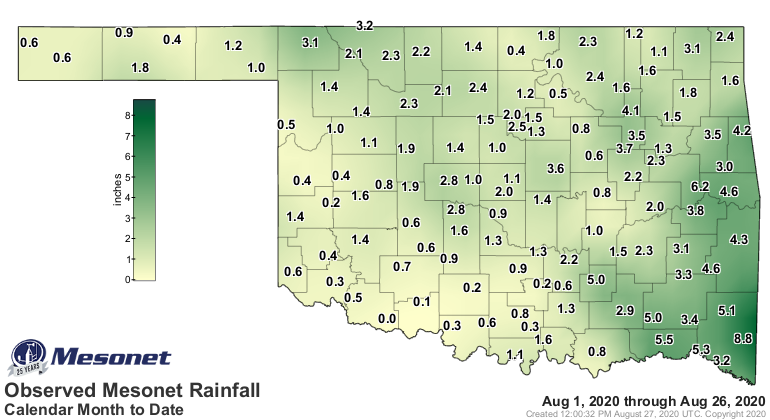
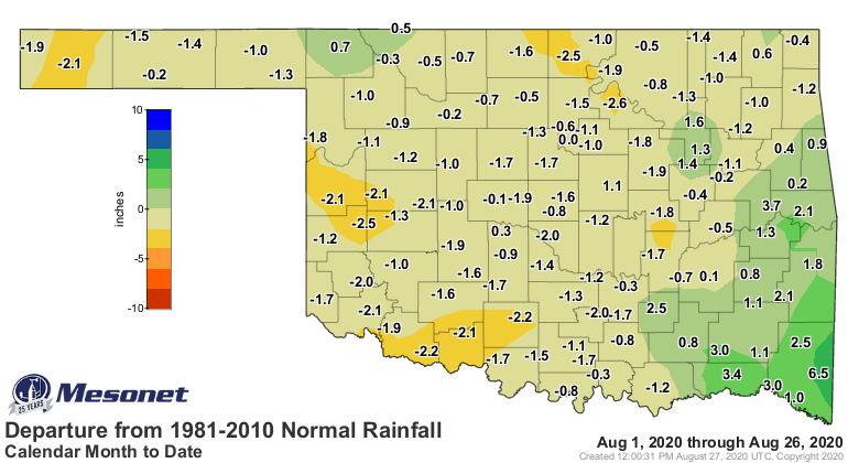
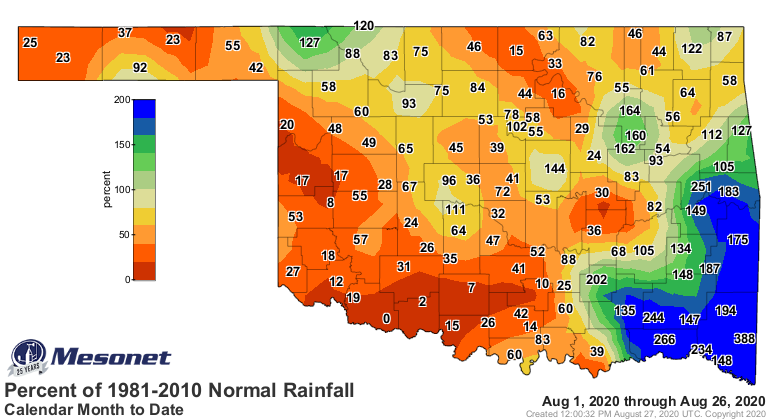
This was really poor timing, and August thus far is not shaping up to be like
our wet July. Augusts tend to do that, earning their rep as our most miserably
hot and dry combo summer month. If your lawn has turned yellow, that's to be
expected.
http://ticker.mesonet.org/archive/20200827/month.meso.png
http://ticker.mesonet.org/archive/20200827/month.norm_dep.png
http://ticker.mesonet.org/archive/20200827/month.norm_pct.png
Most parts of the state are comparing unfavorably to August 2000, which is not
good territory.
http://ticker.mesonet.org/archive/20200827/aug1-27-rain-stats.png
Yeah, not pretty, right? (Those are the same words I say every time I look
in the mirror...my self esteem fluctuates inversely with the amount of drought
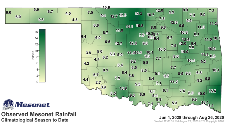
each week). Heck, the summer itself has been downright nasty for most folks, at
least precip-wise.
http://ticker.mesonet.org/archive/20200827/summer-meso.png
http://ticker.mesonet.org/archive/20200827/summer-rain-depart.png
http://ticker.mesonet.org/archive/20200827/summer-rain-pct.png
http://ticker.mesonet.org/archive/20200827/summer-stats.png
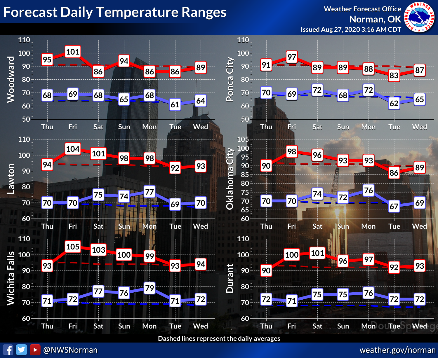
There might be help on the horizon. A series of cold fronts will start Saturday
and then a couple of times next week, with each bringing some cooler air and
a chance of rain.
http://ticker.mesonet.org/archive/20200827/7day-rain-forecast.gif
http://ticker.mesonet.org/archive/20200827/nws-norman-7day-temps.png
Tomorrow is going to be a bear, though, with triple-digits spread about and heat
indices up close to 110.
http://ticker.mesonet.org/archive/20200827/friday-forecast-highs.png
The Monday map looks much better, if'n you're in northern OK, at least.
http://ticker.mesonet.org/archive/20200827/monday-forecast-highs.png
Fall is JUST around the corner. I'm serious. Might be a big corner, though.
Gary McManus
State Climatologist
Oklahoma Mesonet
Oklahoma Climatological Survey
(405) 325-2253
gmcmanus@mesonet.org
==================================================
The OCS/Mesonet Ticker
https://ticker.mesonet.org/
To subscribe or unsubscribe from the Ticker
or for questions about the Ticker or its content
Phone or Email the Ticker Manager at OCS
Phone: 405-325-2253 Email: ticker@mesonet.org
---------------------------------------------------
-C- Copyright 2024 Oklahoma Climatological Survey
===================================================
|


 Tweet
Tweet