MESONET TICKER ... MESONET TICKER ... MESONET TICKER ... MESONET TICKER ...
July 27, 2011 July 27, 2011 July 27, 2011 July 27, 2011
You asked for a hurricane ...
Okay, I'm getting way off the road here, nearly into the bar ditch, but everybody
has been clamoring for a tropical system to come save us. Well, here you go, a
fantasy-cast effort to conjure one up.
http://ticker.mesonet.org/archive/20110727/image_full2.gif
Here's a bit of text from the NWS' National Hurricane Center (sorry for the
shouting):
"THUNDERSTORM ACTIVITY ASSOCIATED WITH A TROPICAL WAVE NEAR THE
YUCATAN CHANNEL CONTINUES TO BECOME BETTER ORGANIZED...AND RADAR
DATA FROM MEXICO SUGGESTS THAT A CIRCULATION COULD BE FORMING ABOUT
50 MILES NORTHEAST OF CANCUN. IF CURRENT TRENDS CONTINUE...A
TROPICAL DEPRESSION COULD DEVELOP LATER TODAY. INTERESTS IN THE
NORTHEASTERN YUCATAN PENINSULA...AS WELL AS THE CENTRAL AND WESTERN
GULF OF MEXICO...SHOULD MONITOR THE PROGRESS OF THIS SYSTEM AS IT
MOVES WEST-NORTHWESTWARD NEAR 15 MPH. THIS SYSTEM HAS A HIGH
CHANCE...80 PERCENT...OF BECOMING A TROPICAL CYCLONE DURING THE
NEXT 48 HOURS. AN AIR FORCE RESERVE HURRICANE HUNTER AIRCRAFT IS
SCHEDULED TO INVESTIGATE THIS SYSTEM LATER TODAY."
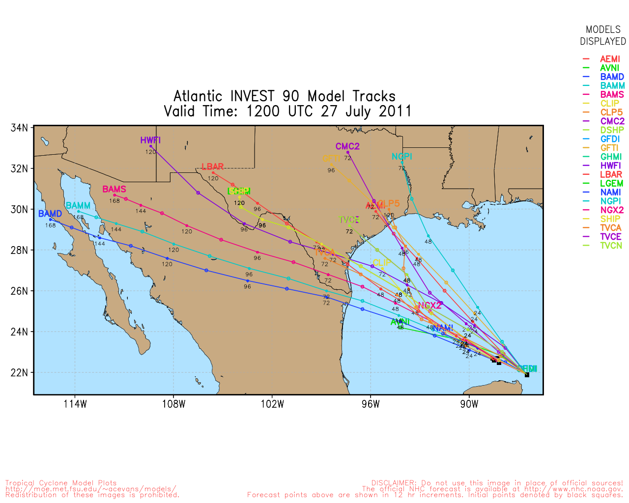
The forecast models used by the NHC are showing general west-northwest
movement of the tropical system with landfall somewhere along the Texas coast
in the 72-hour time frame.
http://ticker.mesonet.org/archive/20110727/tracks.png
Now what happens after that 72-hour period is key. The thing could continue
west and exit into the Pacific and never affect Oklahoma. It could also continue
west, exit into the Pacific and then double back and move over Oklahoma. In
times of weak mid- and upper-level flow, these systems can act just a tad
erratically. Should it get caught up along the edges of the upper-level high
that has camped over the Southern Plains, maybe it can curve back to the
northeast? And due to that lack of flow, even if it just becomes an upper-level
disturbance, it could hang around and give us some good rains.
Again, just a fantasy-cast at this point, but the first real hope for tropical
relief this season. And remember this is a Panhandle boy trying to figure
out the tropics. But keep this in mind ... tropical rains and drought don't
mix well. With less vegetation and rock-hard ground, intense rains bring lots
of flash-flooding. Something to keep an eye on for next week.
Gary McManus
Associate State Climatologist
Oklahoma Climatological Survey
(405) 325-2253
gmcmanus@mesonet.org
==================================================
The OCS/Mesonet Ticker
https://ticker.mesonet.org/
To subscribe or unsubscribe from the Ticker
or for questions about the Ticker or its content
Phone or Email the Ticker Manager at OCS
Phone: 405-325-2253 Email: ticker@mesonet.org
---------------------------------------------------
-C- Copyright 2024 Oklahoma Climatological Survey
===================================================
|


 Tweet
Tweet