MESONET TICKER ... MESONET TICKER ... MESONET TICKER ... MESONET TICKER ...
October 26, 2020 October 26, 2020 October 26, 2020 October 26, 2020
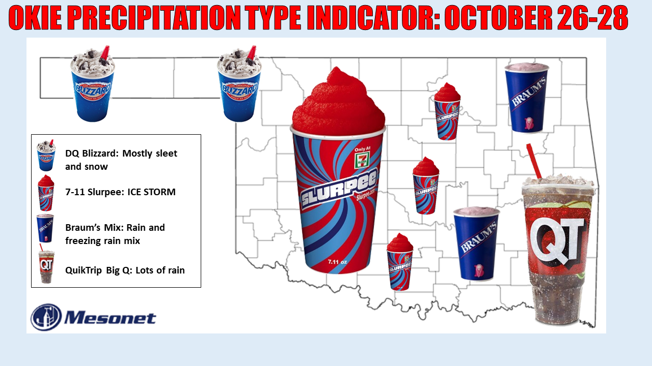
You gotta be kidding me
http://ticker.mesonet.org/archive/20201026/statewide-fastfood-oct2020.png
Only in Oklahoma would Mother Nature be dumb enough to end a drought with an ICE
STORM!
BWAHAHAHAHAHAHAHAHA!!
BWAHAHAHA!!
HAHAHAHA!
HAHA
ha ha
Oh. Sorry for the maniacal laughter, but that about covers it. And we're gonna
have a near blizzard in the Panhandle, enough sleet to fill a cast iron skillet
in the northwest, up to an inch of freezing rain across SW through central OK,
and then 4-5 inches of rain down to the southeast. All this moisture and way too
much cold weather to work with.
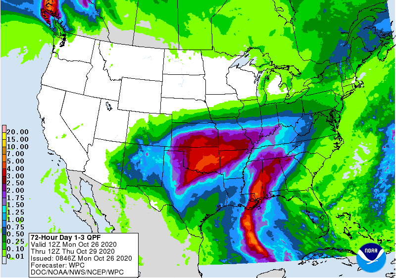
http://ticker.mesonet.org/archive/20201026/3day-rain-totals.gif
http://ticker.mesonet.org/archive/20201026/current-temps.png
http://ticker.mesonet.org/archive/20201026/tonights-lows.png
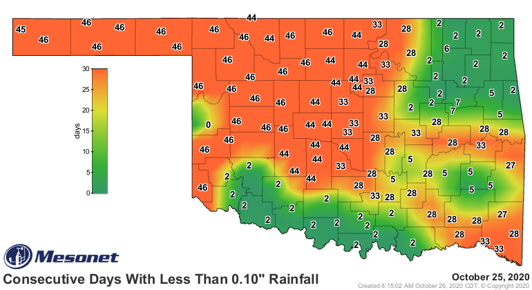
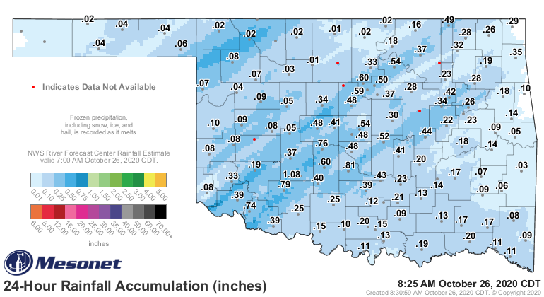
Enough rain already to make improvements in the drought in some places, but LOTS
more coming. This is after some locations have gone nearly 50 days without
significant (in some cases, ANY) moisture.
http://ticker.mesonet.org/archive/20201026/mesonet.rainfall.tenthinch.png
http://ticker.mesonet.org/archive/20201026/24hour-rain-totals.png
So there you go. The key to your winter storm experience, as parodied in the
precipitation type indicator above, depends on that elusive freezing line over
the next 24-36 hours; not only at the surface, but above the surface as well.
Therefore, the forecast is rife with uncertainty, and uncertain about rife. I
don't even know what "rife" means, but when you have winter storm brain, you just
go with it!
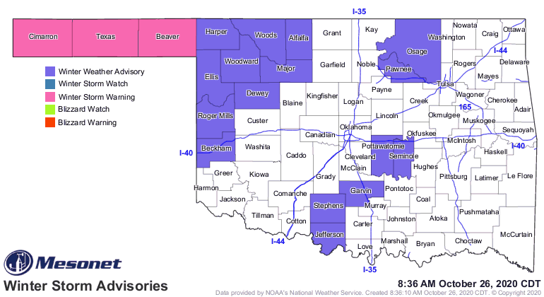
We have a Winter Storm Warning for the Panhandle, Winter Storm Watch in the
NW and just to the eastern edge of the ice storm. What Ice Storm? Ohhhh, THAT
Ice Storm!
http://ticker.mesonet.org/archive/20201026/latest.oklahoma.winter.gif
http://ticker.mesonet.org/archive/20201026/latest.oklahoma.snowice.gif
We're gonna have to hope and pray that the temperature rises above freezing with
a sort of diffuse warm infusion of air from the southeast tomorrow, after it
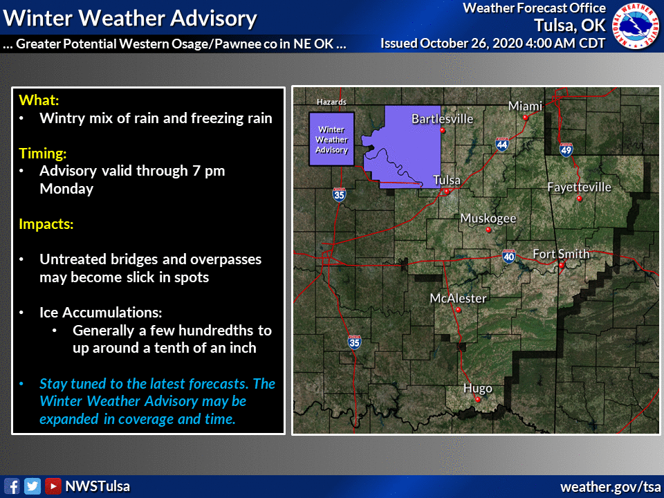
drops tonight. Here is what the local NWS offices are saying about today and
tomorrow.
http://ticker.mesonet.org/archive/20201026/nws-norman-winter.monday.png
http://ticker.mesonet.org/archive/20201026/nws-norman-winter.tuesday.png
http://ticker.mesonet.org/archive/20201026/nws-norman-total.ice.accum.png
http://ticker.mesonet.org/archive/20201026/nws-tulsa-winter.monday.png
http://ticker.mesonet.org/archive/20201026/nws-amarillo-snow.totals.png
Luckily temperatures are forecast to rise back to more Octoberish levels
Wednesday into the weekend, then we can start the wackiness all over again.
http://ticker.mesonet.org/archive/20201026/nws-norman-7day-temp-forecast.png
The forecast is much too complex to try and quibble over what area receives
what precipitation type on what day, so at this point, for goodness sakes, tune
into your favorite media weather source and use whatever app you can to get the
latest from your local NWS office. However, we will reiterate that ice storm
warning:
...ICE STORM WARNING IN EFFECT UNTIL 1 PM CDT WEDNESDAY...
* WHAT...Periods of significant icing through at least Wednesday
morning. Ice accumulations up to one-half inch will be common,
with some locations possibly receiving upwards of one inch.
There will also be accumulations of sleet.
* WHERE...Central, northern, and southwest Oklahoma and western
and northern Texas.
* WHEN...Until 1 PM CDT Wednesday.
* IMPACTS...Expect power outages and widespread tree damage due to
the ice. Travel could become very dangerous.
http://ticker.mesonet.org/archive/20201026/latest.oklahoma.snowice.gif
Don't be afraid, be prepared!
Gary McManus
State Climatologist
Oklahoma Mesonet
Oklahoma Climatological Survey
(405) 325-2253
gmcmanus@mesonet.org
==================================================
The OCS/Mesonet Ticker
https://ticker.mesonet.org/
To subscribe or unsubscribe from the Ticker
or for questions about the Ticker or its content
Phone or Email the Ticker Manager at OCS
Phone: 405-325-2253 Email: ticker@mesonet.org
---------------------------------------------------
-C- Copyright 2024 Oklahoma Climatological Survey
===================================================
|


 Tweet
Tweet