Ticker for September 26, 2012
MESONET TICKER ... MESONET TICKER ... MESONET TICKER ... MESONET TICKER ...
September 26, 2012 September 26, 2012 September 26, 2012 September 26, 2012
Lots of things to talk about today
Lots of things to talk about today. Is there an echo in here? First and foremost,
it rained last night! Definitely a cause for celebration for those that got wet,
and hopefully signs of things to come over the next several days. In fact, it's
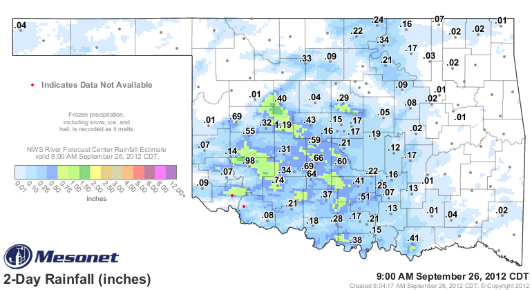
still raining in eastern Oklahoma. Here's the Mesonet total map (I went back two
days just in case). It shows mostly light rain, but a few areas pockmarked with
over an inch.
The storms that moved through the state formed into a bow echo, a particular
formation that can be indicative of exceptionally strong winds. The Mesonet
recorded several instances of gusts 60 mph or greater last night, including a 70
mph gust from our site at Ketchum Ranch near Duncan and a 72 mph reading at
Butler.
-****-
Station Wind Gusts Date Time
Butler 72 mph Sep 25 7:20 PM CDT
Ketchum Ranch 70 mph Sep 26 4:55 AM CDT
Bessie 67 mph Sep 25 7:45 PM CDT
Medicine Park 66 mph Sep 26 2:45 AM CDT
Minco 66 mph Sep 25 9:40 PM CDT
Minco 65 mph Sep 25 9:35 PM CDT
Hobart 61 mph Sep 25 8:50 PM CDT
Medicine Park 60 mph Sep 25 10:15 PM CDT
Weatherford 60 mph Sep 25 8:15 PM CDT
Weatherford 60 mph Sep 25 8:05 PM CDT
Bessie 60 mph Sep 25 7:50 PM CDT
Weatherford 59 mph Sep 25 8:10 PM CDT
Bessie 59 mph Sep 25 7:40 PM CDT
-***-
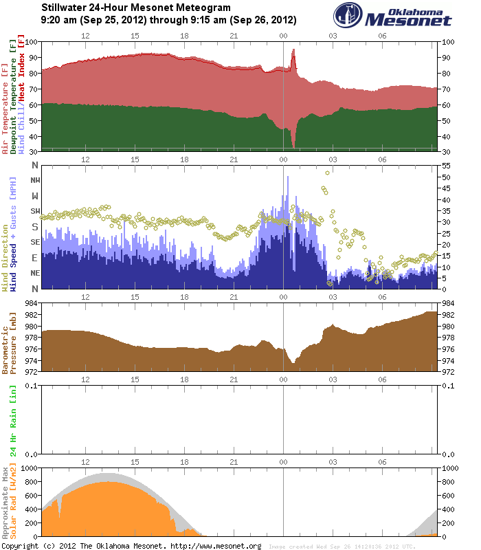
Our Stillwater site got into the act as well with a thought-to-be-rare-but-
known-to-be-more-common-since-the-Mesonet-came-online heat burst last night. The
Stillwater meteogram tells the story. Winds gusted from the south at about 50
mph last night about 12:15am and the temperatures rose from 83 degrees at
12:10am to 95 degrees at 12:35am. The dewpoint and relative humidity bottomed
out at that time, giving Stillwater a nice blast with the hair drier. Notice
not a single drop of rain fell in the rain gauge (maybe it did but evaporated).
All of those factors are a telltale sign of a heat burst, a dying storm dumping
it's evaporatively-cooled air to the surface where it compresses and warms (i.e.,
the hair drier effect ... or in my case, a scalp drier).
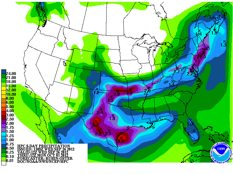
As for future rainfall potential, the HPC is still thinking lots of nice rain
for Oklahoma, still mentioning the interaction of the remnants of Hurricane
Miriam and the stationary front across our area. The key to it all is the
return of moisture over the Southern Plains from our old friend the Gulf of
Mexico. There will be a lot of water in the atmosphere looking for a focus, and
the parameters above should give us that focus.
Whatever the reason, we likes!
Gary McManus
Associate State Climatologist
Oklahoma Climatological Survey
(405) 325-2253
gmcmanus@mesonet.org
September 26 in Mesonet History
| Record | Value | Station | Year |
|---|---|---|---|
| Maximum Temperature | 101°F | SLAP | 2020 |
| Minimum Temperature | 29°F | CAMA | 2000 |
| Maximum Rainfall | 7.70 inches | WEST | 1996 |
Mesonet records begin in 1994.
Search by Date
If you're a bit off, don't worry, because just like horseshoes, “almost” counts on the Ticker website!