MESONET TICKER ... MESONET TICKER ... MESONET TICKER ... MESONET TICKER ...
September 25, 2012 September 25, 2012 September 25, 2012 September 25, 2012
Potpourri
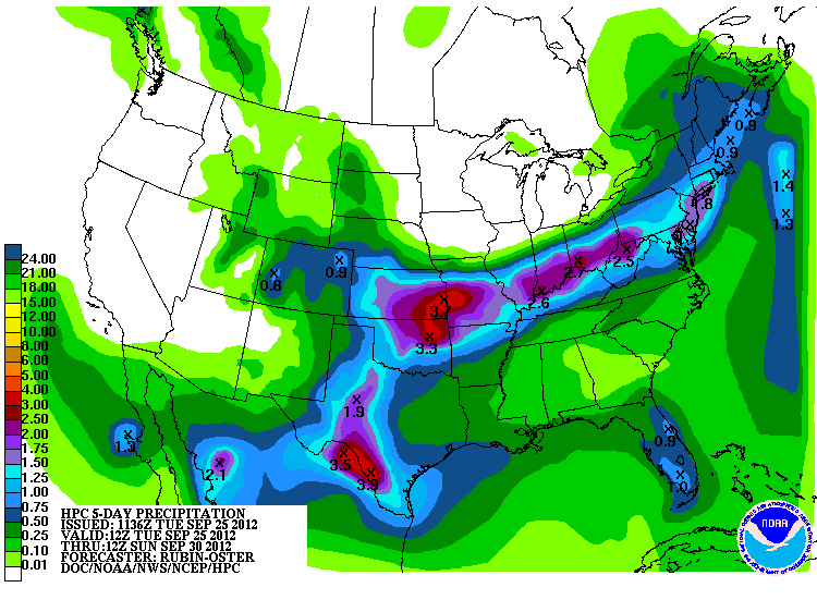
Miriam, we hardly knew ya?
The HPC is still thinking good thoughts about Miriam, the stalled front and
Oklahoma.
http://ticker.mesonet.org/archive/20120925/5-day-precip.gif
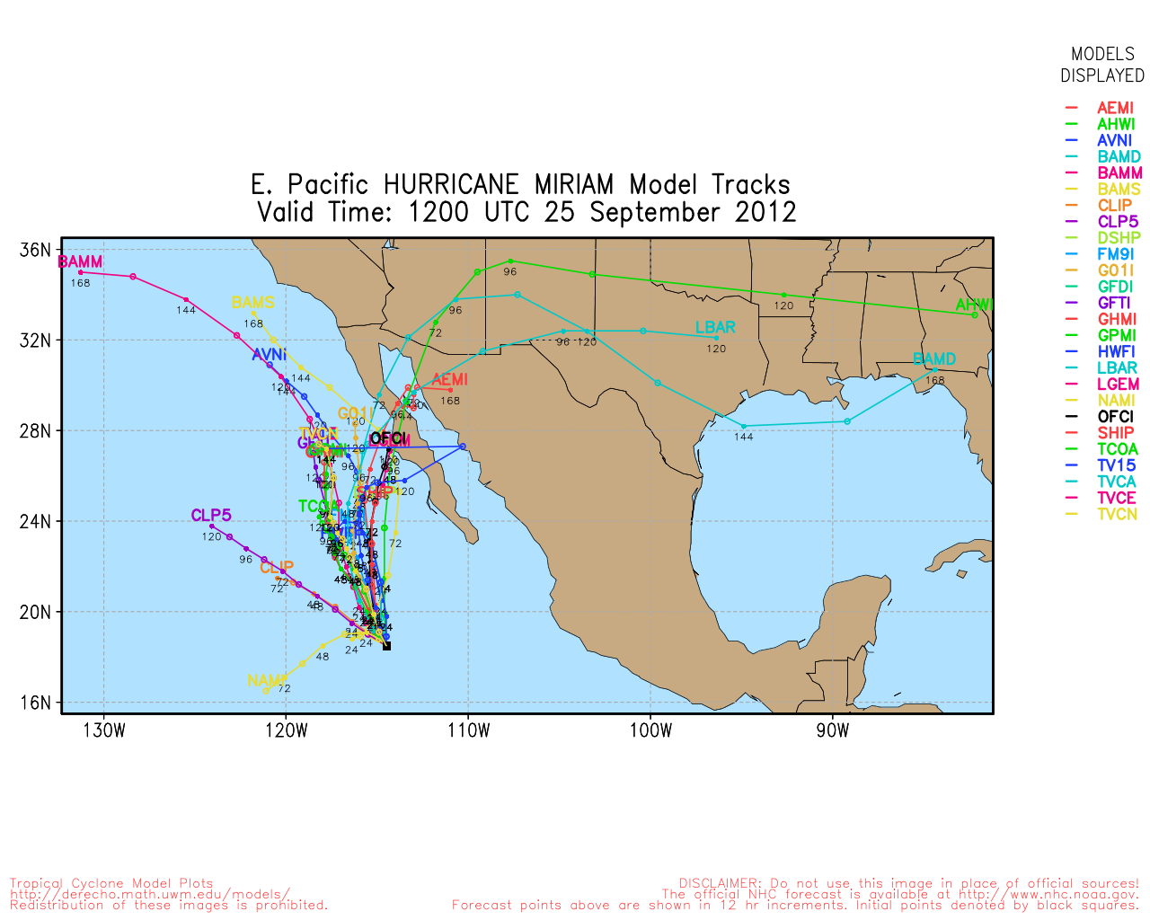
I haven't seen much optimism from local forecasters just yet, and there are
pretty good reasons for that:
1. Miriam to curve back to the northeast
2. She has to survive the trip over the Rockies
C. There needs to be moisture return from the Gulf for her to work with (the
mid-level moisture that can make it over the mountains ain't the key ... the
Gulf of Mexico runs Bartertown for Oklahoma)
The tracks still look doable, at least, and good return flow from the Gulf
should begin shortly with these strong southerly winds.
http://ticker.mesonet.org/archive/20120925/miriam-forecast-tracks.png
Best to keep hope alive, however, because...
--------------------------------------------------------------------------------
How Now Brown Pasture
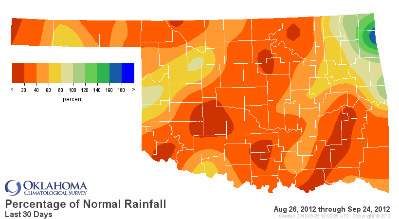
Oklahoma has once again turned a nice shade of brown/yellow after some timely
rains a few weeks ago. Rainfall over the last 30 days has taken a turn for the
worse along with our vegetation, lakes, stock ponds, soils, etc. The 1.49 inches
we've seen on average across the state over the last 30 days is 2.09 inches below
normal and the 10th driest Aug. 26-Sep. 24 dating back to 1921. Only extreme
northeastern Oklahoma has been above normal through that time.
http://ticker.mesonet.org/archive/20120925/last30daystot.png
http://ticker.mesonet.org/archive/20120925/last30dayspct.png
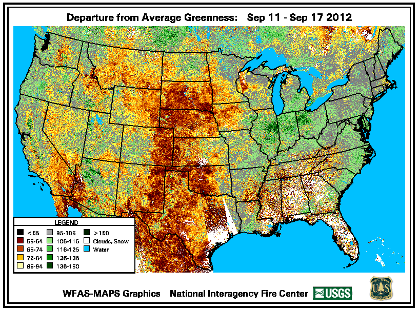
This departure from average greenness map is now a week old, but it shows the
pitiful shape of our vegetation, at least relative to where we should be at
this time of the year.
http://ticker.mesonet.org/archive/20120925/greenness-departure.png
---------------------------------------------------------------------------------
Go jump in a lake!
Just check the depth first. Lake levels have continued to drop through September
for the most part. Some are even facing levels worse than last year. Here
are the levels for select Oklahoma lakes. The figures are percent capacity of
the conservation pool. If they're above 100%, they're into the flood pool. Easy
to see how well off most were in early spring (May 2) and how far they've come
since then. They are sorted by lowest capacity as of September 24.
-****-
May 2 Sep 24 Lowest (2011) 1-year change
Altus Dam 23 18 16 2
Pine Creek 99 41
Tom Steed 61 43 54 -11
Canton 54 45 27 18
Hugo 93 49 56 -7
Waurika 72 57 73 -16
Great Salt Plains 105 60 1 59
Foss 75 65 77 -12
Fort Supply 100 70 61 9
Thunderbird 90 70 73 -3
Eufaula 104 71 73 -2
Skiatook 84 72 64 8
Broken Bow 99 72 71 1
Tenkiller 101 73 83 -10
Keystone 106 74 73 1
Fort Cobb 91 76 80 -4
Wister 100 84 73 11
McGee Creek 104 86 77 9
Oologah 126 86 86 0
Arbuckle 104 88 77 11
Denison Dam (Texoma) 104 89 63 26
Sardis 101 92 88 4
Arcadia 101 93 82 11
Fort Gibson 68 95 17 78
Kaw 110 100 93 7
Pensacola (Grand) 117 104 93 11
Hudson 116 104 99 5
-***-
-------------------------------------------------------------------------------
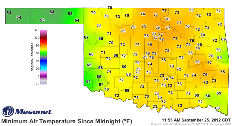
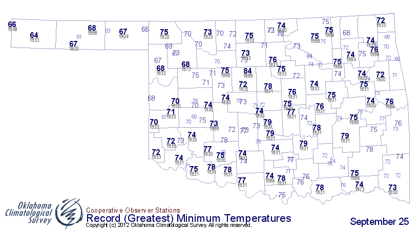
Not helping matters is how hot it has been again (and again and again and again!)
Lows this morning approached record warm levels according to the Mesonet readings.
http://ticker.mesonet.org/archive/20120925/sep25-tmins.png
http://ticker.mesonet.org/archive/20120925/record.hitmin.png
Average highs for this time of the year should be low 80s and lows should be
in the upper 50s to low 60s. We've been there occasionally, it just doesn't
seem to stick around.
Gary McManus
Associate State Climatologist
Oklahoma Climatological Survey
(405) 325-2253
gmcmanus@mesonet.org
==================================================
The OCS/Mesonet Ticker
https://ticker.mesonet.org/
To subscribe or unsubscribe from the Ticker
or for questions about the Ticker or its content
Phone or Email the Ticker Manager at OCS
Phone: 405-325-2253 Email: ticker@mesonet.org
---------------------------------------------------
-C- Copyright 2024 Oklahoma Climatological Survey
===================================================
|


 Tweet
Tweet