Ticker for April 25, 2019
MESONET TICKER ... MESONET TICKER ... MESONET TICKER ... MESONET TICKER ...
April 25, 2019 April 25, 2019 April 25, 2019 April 25, 2019
All eyes on next week
Before we get to the foolishness, how about you take a gander at this press
release from Oklahoma State's Department of Agricultural Sciences and Natural
Resources. This piece was done in coordination with our ongoing celebration of
the Oklahoma Mesonet's 25 anniversary, which we are commemorating throughout
2019. It describes just how widely the Mesonet is used, and how important it is,
to so many people in Oklahoma.
https://bit.ly/2Vwf0L2
And be sure to go like our Facebook and Twitter pages, where we are posting
some pretty fascinating stuff about how the Mesonet benefits the people and
economy of Oklahoma.
https://www.facebook.com/mesonet/
https://twitter.com/okmesonet
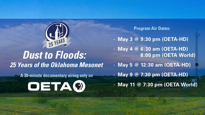
And for sure don't miss out on the 30 minute documentary OETA is running about
our favorite Mesonet, "Oklahoma Mesonet: Endgame." NO NO, just kidding. It's
actually entitled "Oklahoma Mesonet: The Rise of Skywalker." Okay, knock it off.
"Dust to Floods: 25 Years of the Oklahoma Mesonet." Here's the schedule.
NOW, the foolishness.

It's gonna happen sooner or later. No, not my hair growing back (but wouldn't it
be cool if it did?!). Severe weather season. I mean REAL severe weather season.
I know that we've had severe weather impacts already, and for those affected
that was pretty darned serious. We've had exactly ONE tornado (at least
officially) thus far in the state, an EF1 that struck near Shattuck that damaged
a couple of homes and then the usual sheds, trees and fences that became
collateral damage. There might have been a second tornado from that storm, but
the NWS hasn't officially officialized it yet. We've had some gigantic hail and
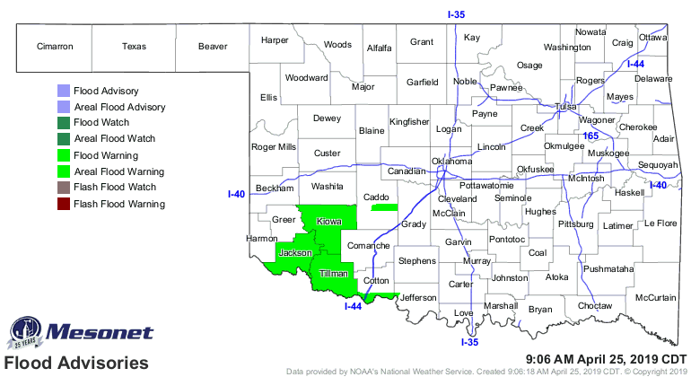
severe winds, and of course flooding. Heck, we're still seeing flooding right now
from the ran earlier this week!
But we can all agree that overall, the severe weather season for the spring thus
far has been pretty benign. But it's gonna happen eventually. Mother Nature is
gonna get serious. It's Oklahoma, late April. And this Ticker isn't meant to
frighten you. If I wanted that, I'd post my picture. No, this Ticker is to get
the point across that preparedness is the key. Why now? Well, our local severe
weather forecasting gurus are noticing something popping up for next week. Still
a LONG time away, relatively speaking, but Tuesday could be a day to start
preparing for. You saw it on the top graphic, a a bit of yellow on the maps
signalling a "slight" chance for severe weather. Doesn't seem too alarming, but
when it shows up 5 days in advance, it catches your attention. Because while
"slight" might drop to "marginal" or even disappear once the forecasts start to
coalesce a bit better, it can also go up to "enhanced," "moderate" or "high."
Here's what the Storm Prediction has to say:
"...Tuesday/Day 6 to Thursday/Day 8...
On Tuesday, a shortwave trough is forecast to move northeastward
into the southern Plains over a moist and unstable airmass. Ahead of
the system, a pronounced low-level jet is forecast to develop. This
combined with moderate to strong deep-layer shear will be favorable
for a severe threat Tuesday afternoon across parts of Texas and
Oklahoma. The setup for Tuesday involves a well-defined shortwave
trough with a low to mid-level jet couplet, which would be favorable
for a significant severe threat over the warm sector. For this
reason, will add a 15 percent contour area in the southern Plains
for Tuesday.
Now here's a bit of caution from the folks at the Norman NWS office:
"While the severe storm threat is present, there may be several
complicating factors with regards to ongoing convection early in
the day and convective overturning that could limit a more organized
severe potential Tuesday. We`ll need to assess trends leading up to
Tuesday and can speak more about the breadth and magnitude of severe
potential then."
And the NWS Tulsa office as well:
"This will mark the beginning of a rather unsettled spring pattern
that will persist through a good portion of next week with the
near zonal flow gradually transitioning to a western trough,
eastern ridge pattern. Mid range models still depict a more
robust shortwave moving into the plains by Tue/Wed, with a sfc
boundary in the vicinity. Details at this time remain very
uncertain but the overall message will be for higher chances of
thunderstorms by the early to middle part of next week, with
seasonably appropriate levels of instability and shear supporting
severe weather chances much of the week."
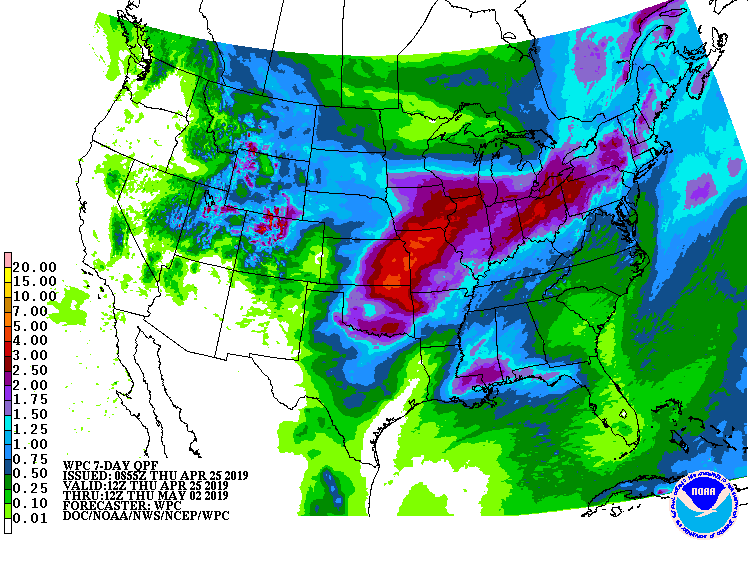
Flooding could also be a continuing issue, as the forecasters note that the
precipitable water (i.e., the amount of moisture re available in the atmosphere
to fall as rain) is going to be relatively high for this time of year, which
is a period where it's pretty high to begin with. That is starting to show up
on the 7-day rainfall forecast map. This forecast will of course change as
well as we move forward.
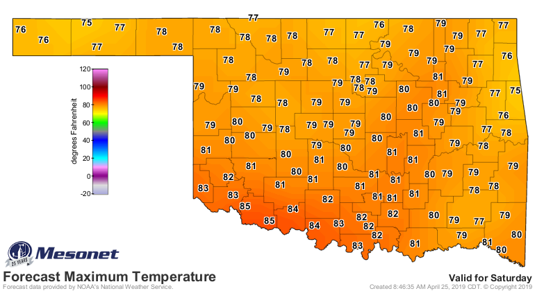
So don't panic. Don't wail and gnash your teeth. And whatever you do, don't
gnash and wail your teeth. It's going to be a fairly nice weekend. A perfect
chance to clean that storm cellar, stock up your emergency supplies, put new
batteries in the weather radio, etc.
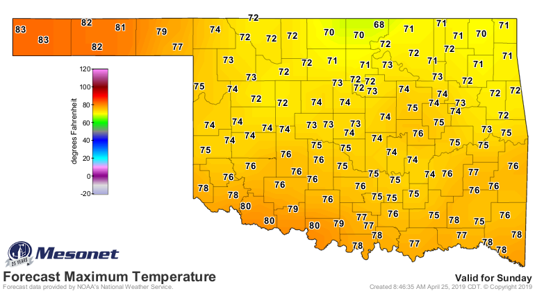
Note that we will also have chances here and there this weekend for some rain,
and somewhat marginal risks of severe weather. But next week, Mother Nature
gets a bit more serious. Possibly.
Gary McManus
State Climatologist
Oklahoma Mesonet
Oklahoma Climatological Survey
(405) 325-2253
gmcmanus@mesonet.org
April 25 in Mesonet History
| Record | Value | Station | Year |
|---|---|---|---|
| Maximum Temperature | 105°F | ERIC | 2012 |
| Minimum Temperature | 28°F | BURN | 2013 |
| Maximum Rainfall | 4.84 inches | MEDF | 2009 |
Mesonet records begin in 1994.
Search by Date
If you're a bit off, don't worry, because just like horseshoes, “almost” counts on the Ticker website!