Ticker for September 24, 2012
MESONET TICKER ... MESONET TICKER ... MESONET TICKER ... MESONET TICKER ...
September 24, 2012 September 24, 2012 September 24, 2012 September 24, 2012
Hurricane Miriam to the rescue?
After the Hurricane Isaac letdown, I hesitate to jinx the next chance for tropical
relief, but hope rolls on! There is more and more talk about the state benefiting
from the remnants of Hurricane Miriam, currently churning away off the west coast
of Mexico. The model output has it moving over the Desert Southwest at some point
late this week.
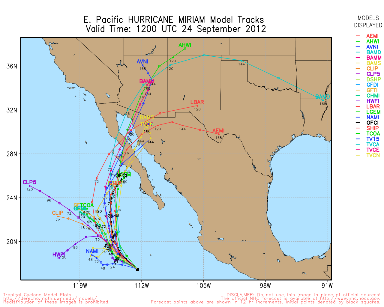
As luck would have it, there will also be a frontal boundary hanging around our
area as well. Now state weather historians will immediately perk up their ears
hearing those two factors could be in play as October approaches. Some of our
most extreme rainfall events on record have occurred when pacific hurricane
remnants and stalled frontal boundaries mingled over the state. Here are our
greatest 1-day through 7-day rainfall totals on record in the state. Enid's massive
one-day total remains the state's greatest 1-day rainfall total in history, but
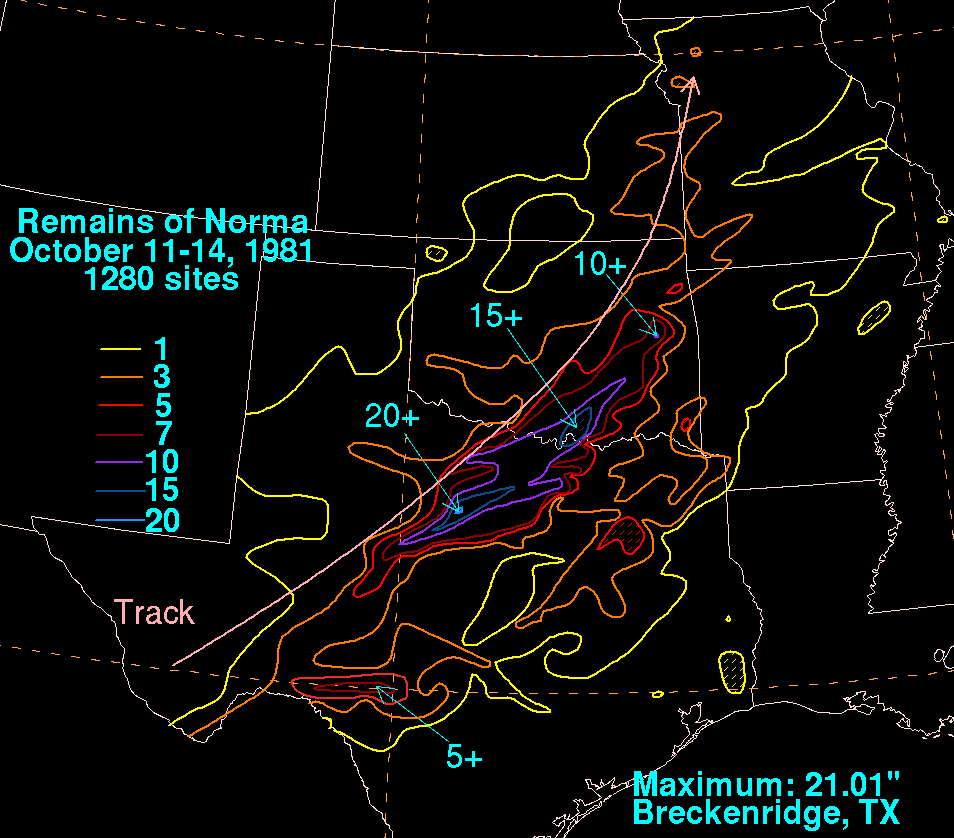
the 2-day through 7-day totals all belong to pacific hurricane Norma and the front
she hung out with back in October 1981 (more on Norma at the end of the Ticker).
-****-
Duration Ppt Total Ending Date Location
1-day 15.68" Oct 11, 1973 Enid
2-day 18.02" Oct 14, 1981 Tishomingo
3-day 18.68" Oct 14, 1981 Kingston
4-day 22.47" Oct 16, 1981 Tishomingo
5-day 23.12" Oct 17, 1981 Tishomingo
6-day 23.95" Oct 18, 1981 Coalgate
7-day 24.95" Oct 18, 1981 Coalgate
-***-
It would be ridiculous to predict another Norma-type rainfall event, but we can at
least get excited about the possibility of a good soaking rain for parts of the
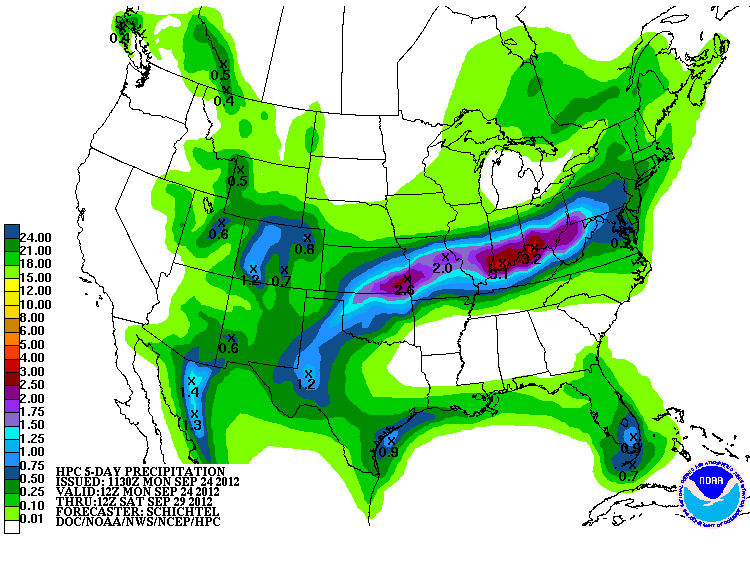
state, right? The HPC is already starting to paint the state with some decent
rainfall amounts in the latest HPC 5-day rainfall outlook, especially in northern
Oklahoma. This map is for rain accumulated from now until Saturday morning (and
it's already a tad old, being released this morning).
As I was mentioning earlier, Oklahoma has had some ginormous rains from pacific
tropical systems interacting with stalled fronts. Probably more so than Atlantic
hurricanes, believe it or not. Here's a brief synopsis on previous encounters
between pacific hurricane remnants and Oklahoma, compiled by former Associate
State Climatologist and the original entire Ticker staff, Deke Arndt. We'll start
with the Grandmomma of them all (at least in modern Oklahoma history), Hurricane
Norma.
----------------------------------------------------------------------------------
Pacific Hurricane Norma, October 1981.
Norma formed off the Mexican coast on the 9th, and quickly became a Category 3
hurricane before weakening slightly and making landfall near Mazatlan. Her
remnants made their way into the southern plains by the 11th and encountered a
stationary front draped across north Texas. Norma?s rains in south-central,
southeast and eastern Oklahoma were both torrential and long-lasting. A swath
stretching from around the Lake Texoma region to Eufaula saw more than a foot of
rain, with local values exceeding 15 inches. The greatest two-day, three-day,
four-day, five-day, six-day and seven-day rainfall totals ever recorded in
Oklahoma are all related to Norma. Two drowned in the state, with at least $50
million in property damage. The system also spawned two F1 tornadoes in southern
Oklahoma, causing two injuries.
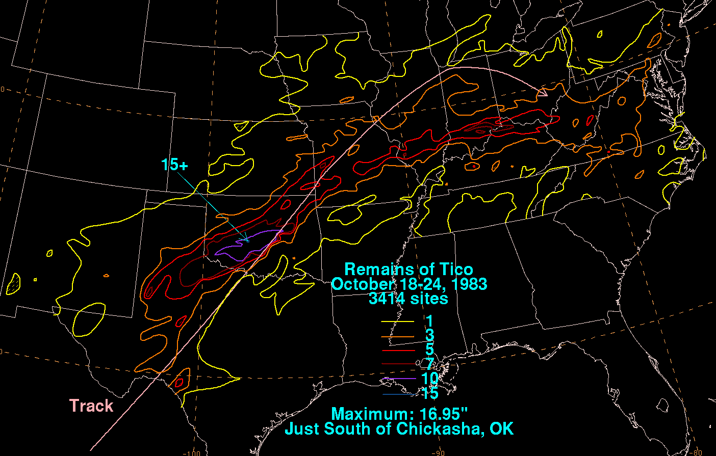
Pacific Hurricane Tico, October 1983.
Most of Oklahoma was already waterlogged by a very wet autumn when Tico?s remnants
met a stalled front in Oklahoma in mid-month. More than a foot of rainfall
drenched the I-44 corridor. Widespread flooding occurred throughout the state,
notably on the irritable Cottonwood Creek in Guthrie, where a man was swept to his
death. A train was derailed in Altus when the tracks were washed away underneath
it. In subsequent days, several locations on the Red and Washita Rivers recorded
all-time high streamflows.
Pacific Hurricane Waldo, October 1985.
Far western Oklahoma is not immune to large rainfall totals from Pacific storms.
Waldo left a wide swath of rain across the northwestern half of Oklahoma, and the
Buffalo area saw more than five inches.
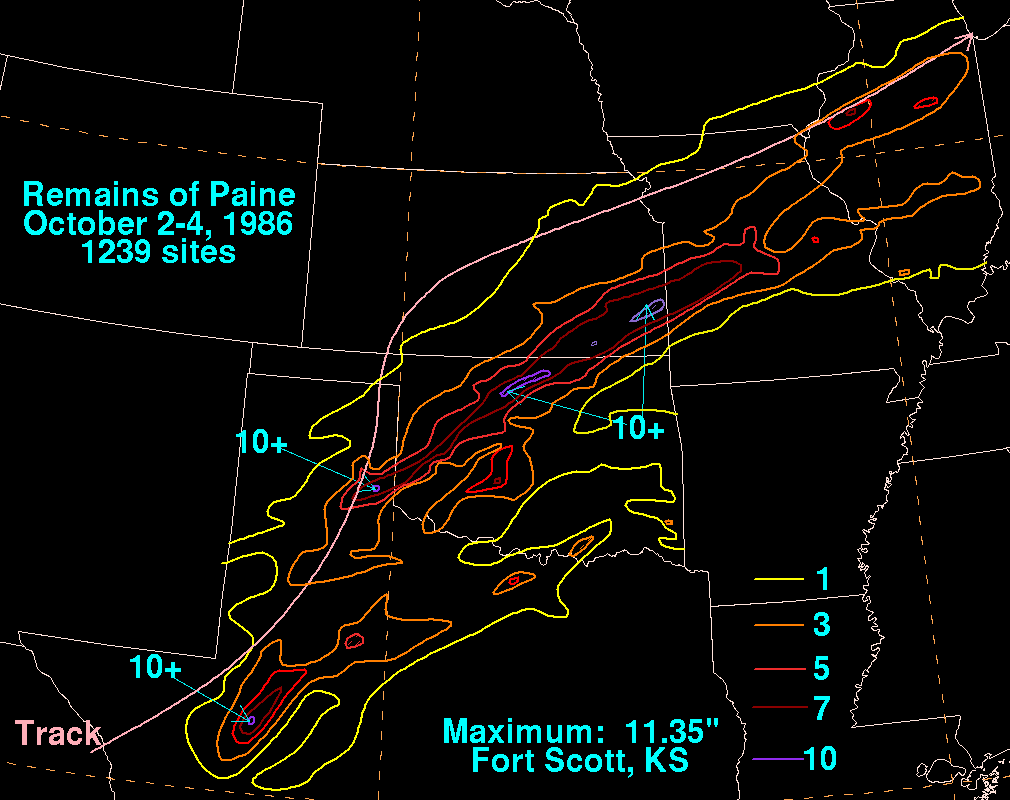
Pacific Hurricane Paine, October 1986.
Accumulations in excess of fifteen inches were commonplace in the opening days of
October 1986. The Oklahoma epicenter of Paine?s downpour lay in the north-central
parts of the state, where upwards of ten inches fell in the Perry area and in Kay
County. The Cimarron River saw its flood of record at several gages in central
Oklahoma, and Tulsa flood damages approached $35 million. Agricultural damages,
particularly in the winter wheat belt, were tremendous.
Pacific Hurricane Raymond, October 1989.
Interestingly, Raymond was a cousin of catastrophic Hurricane Hugo that battered
the Carolinas in 1989. He was spawned in the Pacific by the same traveling
tropical wave that ignited Hugo three weeks earlier in the Atlantic. Raymond?s
rainfall footprint resembled that left by Paine in 1989, but peak accumulations
were less than four inches.
Pacific Hurricane Lester, August 1992.
A major swath of Oklahoma?s wheat belt was the beneficiary of one-to-three-inch
rains related to Lester in late August. Lester also caused major flooding in the
American southwest, as well as minor flooding days later in the Midwest. Very
little of Lester?s impact made the news, because at the same time, Atlantic
Hurricane Andrew was becoming the costliest natural disaster of the 20th Century.
Pacific Hurricane Ismael, September 1995.
After dumping more than half a foot of rain in eastern New Mexico and west Texas,
Ismael left few scars on Oklahoma. However, it did provide nearly three inches of
rainfall to much of the Arbuckles region.
Gary McManus
Associate State Climatologist
Oklahoma Climatological Survey
(405) 325-2253
gmcmanus@mesonet.org
September 24 in Mesonet History
| Record | Value | Station | Year |
|---|---|---|---|
| Maximum Temperature | 101°F | BUFF | 1998 |
| Minimum Temperature | 29°F | BOIS | 2000 |
| Maximum Rainfall | 4.77″ | CLAY | 2019 |
Mesonet records begin in 1994.
Search by Date
If you're a bit off, don't worry, because just like horseshoes, “almost” counts on the Ticker website!