Ticker for July 23, 2012
MESONET TICKER ... MESONET TICKER ... MESONET TICKER ... MESONET TICKER ...
July 23, 2012 July 23, 2012 July 23, 2012 July 23, 2012
It'll get worse before it gets better
That's what Dalton said about the Double Deuce ("Road House"...come on, I know
you've seen it), and it's probably going to work that way with our drought as
well. There doesn't appear to be any widespread relief on the way in the next
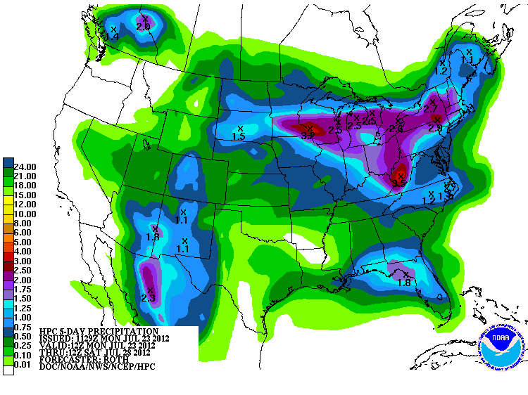
week or so, at least. The latest 5-day precip forecast from the HPC paints us
with a bit of green, but those amounts would still keep us brown, I'm afraid.
Once this next chance of rain moves on by, look for the heat dome to move back
over us and strengthen again. But with each passing day, the rainfall statistics
since spring look worse and worse. I'll just skip to May 1 forward and show you
in pictures from the Oklahoma Mesonet. Keep in mind as you see these that they
encompass the bulk of our rainiest part of the year, May through mid-June.
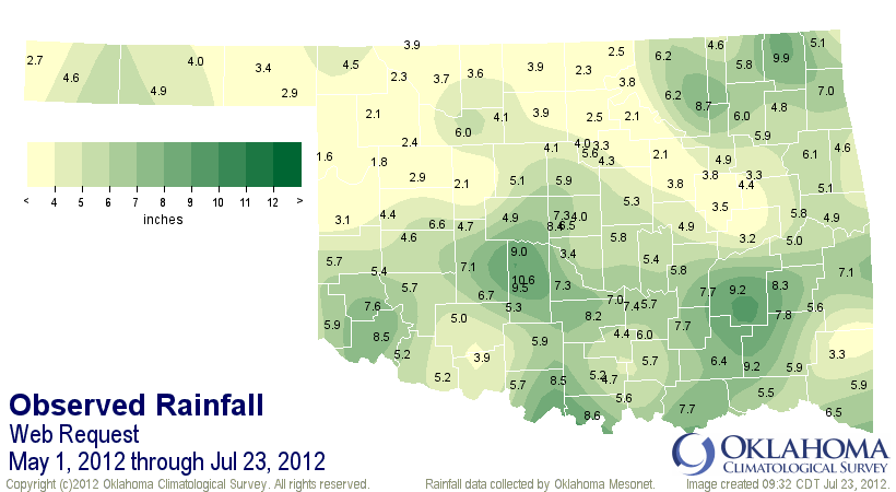
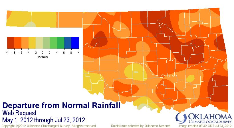
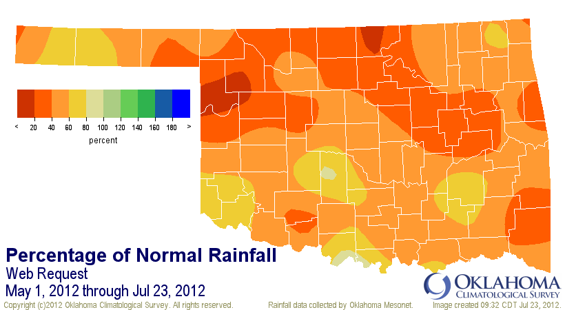
Basically, much of the state just plain missed out on the rainy season this year,
and now are below normal for the summer as well. The statistics and ranking
are just pathetic, and this May 1-July 23 period is now the driest on
record based on the statewide average dating back to 1921.
-****-
Clim. Div. Avg. Total Dep. From Norm Pct. Of Norm Rank since 1921
Panhandle 3.58" -4.57" 44% 3rd driest
N. Central 3.33" -7.63" 30% 1st driest
Northeast 5.62" -6.81" 45% 2nd driest
W. Central 4.08" -6.20" 40% 3rd driest
Central 5.67" -6.26" 48% 5th driest
E. Central 5.31" -7.49" 41% 2nd driest
Southwest 5.95" -4.63" 56% 8th driest
S. Central 6.50" -5.26" 55% 8th driest
Southeast 6.51" -7.23" 47% 2nd driest
Statewide 5.18" -6.22" 45% 1st driest
-***-
And as we've talked about ad nauseam (literally, I'm sick of dealing with
drought/heat), anytime you have severe drought in the summer, you are in for
the heat. The drought just kind of sits there, waiting for the right type of
weather pattern to come along. When it gets that pattern (the upper-level ridge
or "heat dome"), it comes alive and feeds the heat. And the heat feeds the
drought, and so on and so forth. And always remember, it's never too late to
start a heat wave in the summer! Here's where we are so far this year with
days at or above of 100 degrees. To make you feel better, I'll include the count
for the same period last year.
2012: 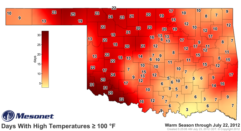
2011: 
Still fairly nasty. What you're really seeing there is basically a rainfall map.
The places with fewer hundreds have gotten a bit more rain and have been in a
bit better shape with soil moisture. LeFlore County in southeastern Oklahoma,
for example, has been the epicenter of the drought in that part of the state
and therefore is a local maximum of extreme heat.
At any rate, the hottest days in Oklahoma are normally from late July into
the first week of August or so. It varies a bit by the area of the state, but
here's a look at the 1981-2010 normal daily high max temperatures for
Stillwater. Hey, I'm flexible! You probably expected Buffalo, right?
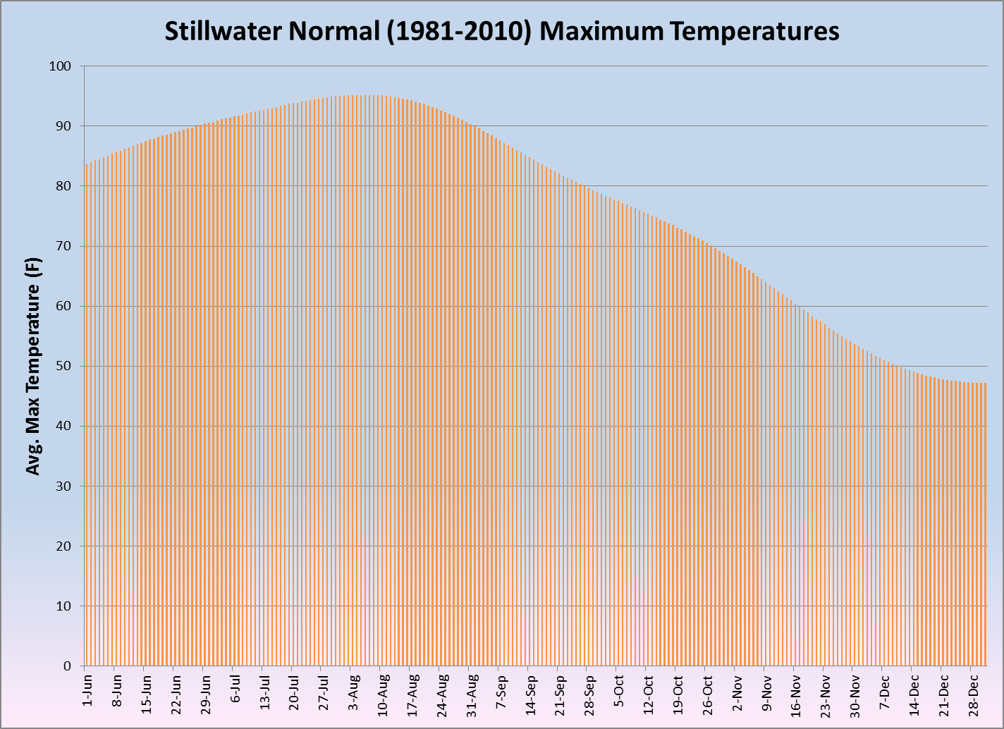
So the maximum temperatures "normally" increase through summer until peaking at
95.2 degrees on August 3-9. It then drops throughout the rest of summer until
really starting to drop off in September.
So yes, it will probably get worse before it gets better. But the fall rainy
(and cool!) season is just around the corner. A rainy August is not something
to expect, but it's not unheard of either.
And yeah, I thought I'd be bigger too (come on, it's on almost every night on
TNT!).
Gary McManus
Associate State Climatologist
Oklahoma Climatological Survey
(405) 325-2253
gmcmanus@mesonet.org
July 23 in Mesonet History
| Record | Value | Station | Year |
|---|---|---|---|
| Maximum Temperature | 109°F | CHER | 2001 |
| Minimum Temperature | 54°F | ELRE | 2019 |
| Maximum Rainfall | 4.28 inches | TAHL | 2013 |
Mesonet records begin in 1994.
Search by Date
If you're a bit off, don't worry, because just like horseshoes, “almost” counts on the Ticker website!