Ticker for June 23, 2011
MESONET TICKER ... MESONET TICKER ... MESONET TICKER ... MESONET TICKER ...
June 23, 2011 June 23, 2011 June 23, 2011 June 23, 2011
Exceptional drought creeps back to the east in Oklahoma
All the heat and wind we have seen in June has taken its toll in the western half
of the state, and the drought we've been mired in since last fall continues to
intensify and persist. Exceptional drought, the worst such designation in the
U.S. Drought Monitor's intensity scale, increased from 10 percent of the state
last week to 33 percent this week. The new map released this morning shows the
ugly details.

In addition to the widespread D4 drought covering virtually the entire western
third of Oklahoma, D3 (extreme) and D2 (severe) drought also shifted back to the
east.
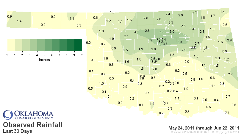
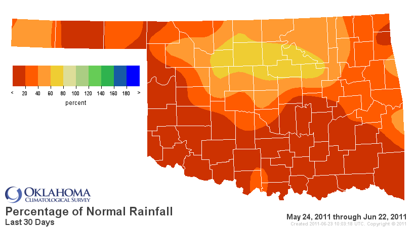
The state missed out on a substantial amount of its normal rainfall during the
last 30 days. According to data from the Oklahoma Mesonet, the May 24-June 22
statewide average rainfall total of 1.24 inches ranks as the driest such period
dating back to 1921. Southwestern and south central Oklahoma suffered through
similar rankings for the last 30 days, receiving a scant 12 percent of normal
rainfall over that period.
Climate Div. Total Rainfall Dep. from Normal Pct of Normal Rank
Panhandle 0.61" -2.41" 20% 3rd driest
N. Central 2.12" -1.99" 52% 12th driest
Northeast 2.06" -2.74" 43% 7th driest
W. Central 0.78" -3.31" 19% 2nd driest
Central 1.88" -2.93" 39% 6th driest
E. Central 1.45" -3.64" 28% 5th driest
Southwest 0.50" -3.83" 12% 1st driest
S. Central 0.58" -4.27" 12% 1st driest
Southeast 0.71" -4.38" 14% 3rd driest
Statewide 1.24" -3.23" 28% 1st driest
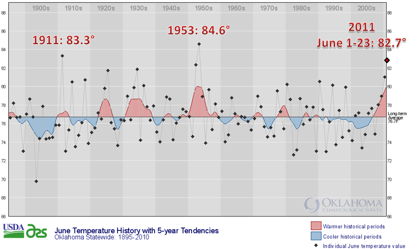
The tremendous early summer heat exacerbated the drought impacts and allowed for
its eastward progress. The statewide average temperature for the month thus far
stands at 82.7 degrees, which would be high enough to rank as the third warmest
June on record for Oklahoma. Number one on June's warmest list goes to 1953
at 84.6 degrees, with 1911 coming in second at 83.3 degrees. During that period,
high temperatures across the state averaged 95.7 degrees, 8.6 degrees above
normal. The average high temperature in southwestern Oklahoma came in at 100.9
degrees.
Here is a time series of statewide average June temperatures in Oklahoma dating
back to 1895. Note June 2011's preliminary rank.
The view from space is as grisly as one would expect. The relative greenness
map from the OK-FIRE program for the week ending June 20 gives a pretty good
picture of where it has rained and where it hasn't. That lack of greenness in
the western half of the state is the primary reason the wildfire season never
found an endpoint during spring.

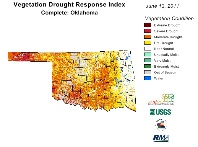
Another view from space is the VEG-DRI picture provided by the USGS and the
National Drought Mitigation Center. It shows the response of vegetation due
to the drought conditions. Note the gray areas, signifying "out of season."
Some of that is due to the bare fields left by wheat harvest and some is due
to the destruction of crops and natural vegetation due to drought.
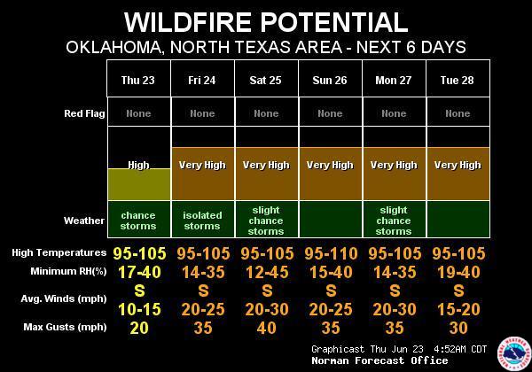
A chance of rain exists today, especially for northern Oklahoma, but those
chances will also be accompanied by high fire danger.

This graphic tells the sad story for the next week as the heat dome shifts over
Oklahoma once again.
The billion-dollar disaster continues unabated, with no end in sight ... yet.
Please remember to visit our new website at http://climate.ok.gov for up-to-date
drought news and other climate/weather information.
Gary McManus
Associate State Climatologist
Oklahoma Climatological Survey
(405) 325-2253
gmcmanus@mesonet.org
June 23 in Mesonet History
| Record | Value | Station | Year |
|---|---|---|---|
| Maximum Temperature | 107°F | EVAX | 2021 |
| Minimum Temperature | 49°F | ANTL | 2001 |
| Maximum Rainfall | 5.64″ | TAHL | 2019 |
Mesonet records begin in 1994.
Search by Date
If you're a bit off, don't worry, because just like horseshoes, “almost” counts on the Ticker website!