MESONET TICKER ... MESONET TICKER ... MESONET TICKER ... MESONET TICKER ...
October 22, 2020 October 22, 2020 October 22, 2020 October 22, 2020
The Jinx
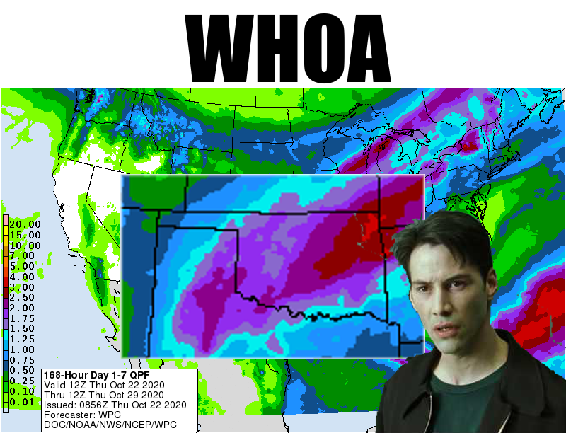
http://ticker.mesonet.org/archive/20201022/7-day-precip-forecast.png
Yep, that's how it happens. You start talking predominantly about drought and a
long dry spell, sound the alarm about more to come with the presence of La Nina,
and Mother Nature is gonna make you look foolish. But this is a good (and frequent)
thing. Deep on the heels of a dry period of about a month and a half without a
drop of moisture, looks like much of western OK has a chance (A CHANCE, not a
sure thing) of getting significant rain/sleet/freezing rain/snow over the next
week or so. For those that planted or will plant wheat, this is a great thing.
Should it happen. And it's going to come in conjunction with another near-historic
cold snap. So combine a cold snap and a wet snap and you get, uhhhh, a cowet snap?
Well, that and maybe a good old fashioned Plains winter storm. You know, the kind
you get in late November or into December?
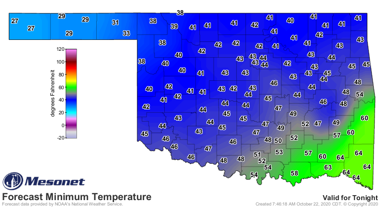
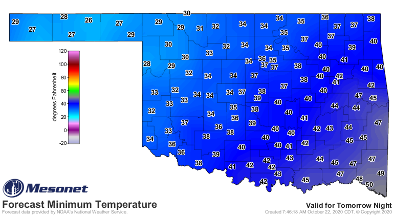
Let's talk about that cold snap first. The cold air gets a bit of a head start
tonight with a cold front that would be bigger news if we didn't know what was
coming on Sunday. The front should provide another freeze tonight in far NW OK,
and highs in the 40s and 50s tomorrow. A possible broader freeze Saturday
morning. YAWN!
http://ticker.mesonet.org/archive/20201022/friday-forecast-lows.png
http://ticker.mesonet.org/archive/20201022/friday-forecast-highs.png
http://ticker.mesonet.org/archive/20201022/saturday-morning-lows.png
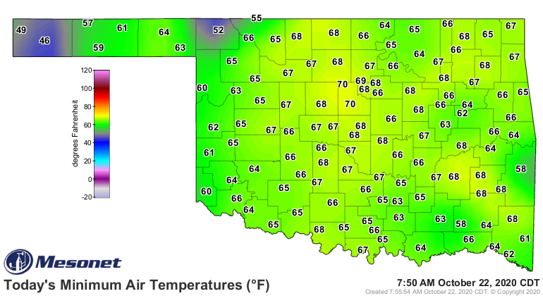
And this is coming on the heels of this morning which saw some possible record
high minimum temperatures. This is all dependent on the timing of the front
tonight. Should it push through before midnight, these lows will drop along
with the front, but we can safely saw this was certainly one of the warmest
October 22 mornings on record, courtesy of strong southerly winds and a good
dose of humidity.
http://ticker.mesonet.org/archive/20201022/todays-lows.png
http://ticker.mesonet.org/archive/20201022/oct22-record-high-mins.png
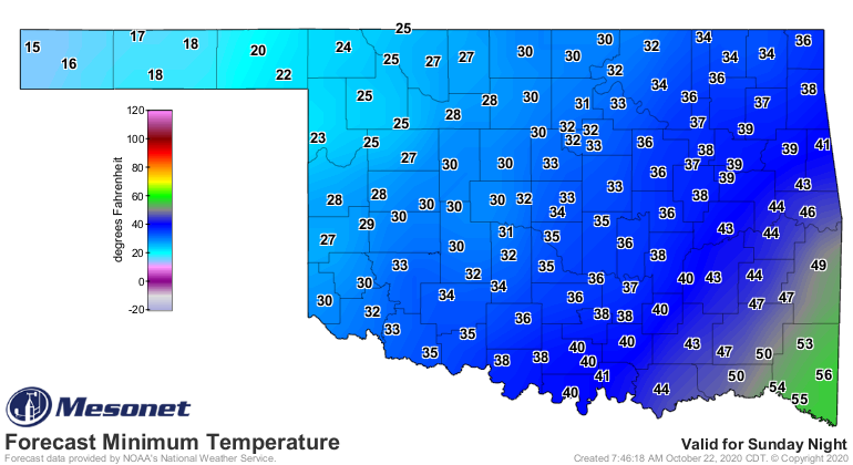
A brief recovery before we get to the front Sunday, and one of the coldest
late-October days, highs and lows, on record it would appear.
http://ticker.mesonet.org/archive/20201022/monday-forecast-lows.png
http://ticker.mesonet.org/archive/20201022/monday-forecast-highs.png
The lowest temperature ever recorded on October 25 in OK is 16 degrees at
Freedom in 2012, so that mark might fall. And the lowest high temperature on
record for the state that day is 37 degrees at Boise City in 1918. That one
could definitely be in jeopardy with forecast highs across much of OK struggling
to get above freezing.
Add all that moisture and you have a mess. More importantly, a mess to forecast.
All modes of winter weather appear possible at this time. Mother Nature will
decide on what she wants eventually, so for now a good dose of preparation is
in order, should we end up with ice, freezing rain, snow, or just a cold cold
rain. And one of the keys will be how long the cold and moisture hang around.
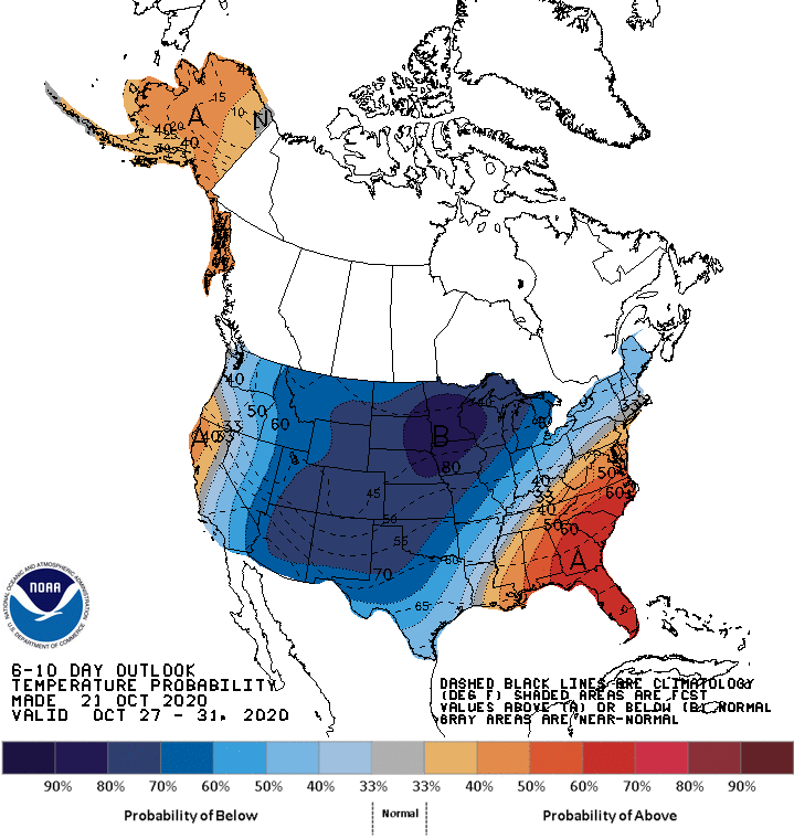
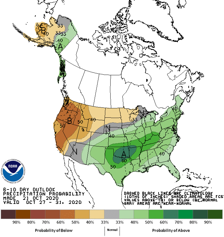
Looks like a significant portion of next week COULD end up looking a lot like
winter, or feel like it at least.
http://ticker.mesonet.org/archive/20201022/oct27-31-temp-outlook.gif
http://ticker.mesonet.org/archive/20201022/oct27-31-precip-outlook.gif
The forecast models are not in unison with one voice just yet, so stay tuned.
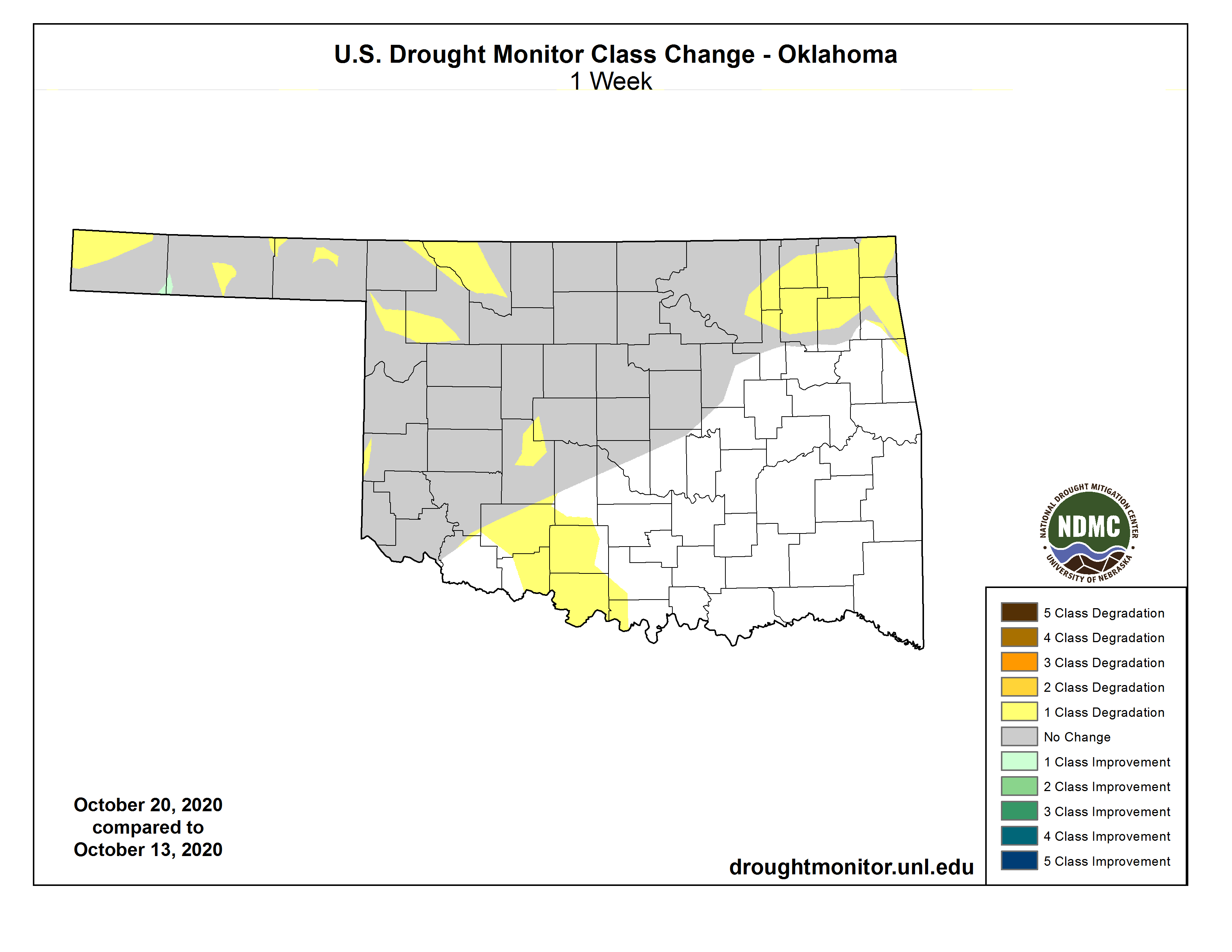
As for the dry weather, not much more talk is necessary there. The new Drought
Monitor map threw some more colors our way (and not in a good way). We have
new abnormally dry conditions in south central OK, and intensification in the
NE and NW.
http://ticker.mesonet.org/archive/20201022/20201020_OK_trd.png
http://ticker.mesonet.org/archive/20201022/1week-change-DM.png
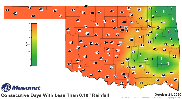
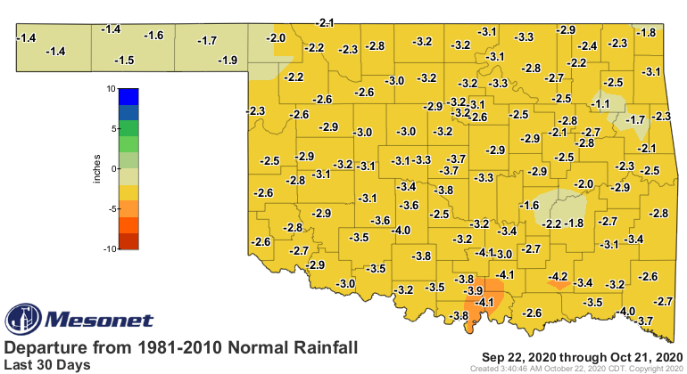
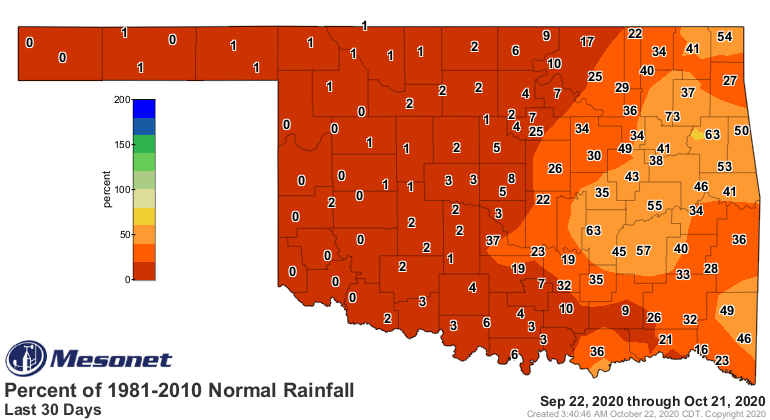
Lack of moisture, ANY moisture, has extended well past 40 days now across
northern and western OK.
http://ticker.mesonet.org/archive/20201022/mesonet.rainfall.tenthinch.png
http://ticker.mesonet.org/archive/20201022/30day-rain-totals.png
http://ticker.mesonet.org/archive/20201022/del30day_rain.current.png
http://ticker.mesonet.org/archive/20201022/pct30day_rain.current.png
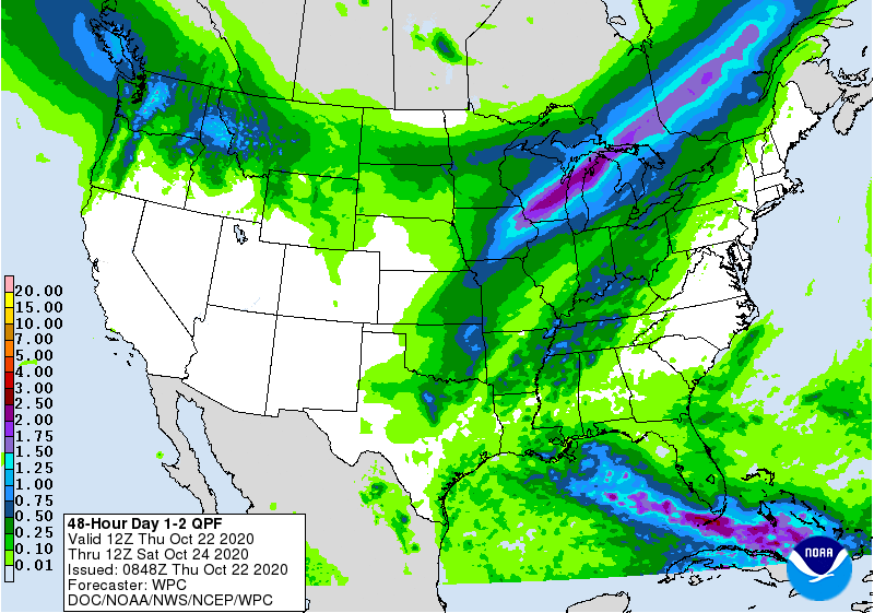
So this will be the best chance in quite awhile to break that streak of no
rainfall. The chances actually start tonight with that first front. Might even
have a few marginally severe storms across NC and NE OK.
http://ticker.mesonet.org/archive/20201022/2day-rain-forecast.gif
But the really fun stuff starts next week, hopefully. The only question now is,
did I jinx it? That would be a jinx (of the rain) of a jinx (of the drought).
2020.
Gary McManus
State Climatologist
Oklahoma Mesonet
Oklahoma Climatological Survey
(405) 325-2253
gmcmanus@mesonet.org
==================================================
The OCS/Mesonet Ticker
https://ticker.mesonet.org/
To subscribe or unsubscribe from the Ticker
or for questions about the Ticker or its content
Phone or Email the Ticker Manager at OCS
Phone: 405-325-2253 Email: ticker@mesonet.org
---------------------------------------------------
-C- Copyright 2024 Oklahoma Climatological Survey
===================================================
|


 Tweet
Tweet