MESONET TICKER ... MESONET TICKER ... MESONET TICKER ... MESONET TICKER ...
August 22, 2023 August 22, 2023 August 22, 2023 August 22, 2023
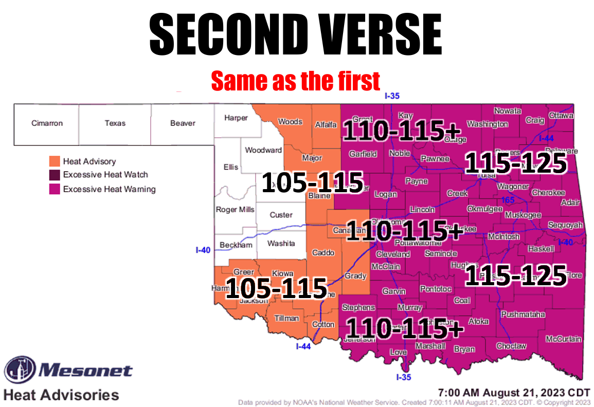
Sing along now
https://ticker.mesonet.org/archive/20230822/latest.oklahoma.heat.png
Yesterday when I posted this same graphic (with a different and far more clever-
in-my-own-mind headline) to Facebook, I was accused of being a sensationalist. Ya
know, after I visited dictionary.com, I was offended! No, not by being called
a sensationalist...by my own brain for not knowing what the word meant! Okay,
maybe I did know, but I got the last laugh. Now that laugh came with heat stroke,
but I won!
Right?
Well, no, we all lost yesterday. Not only did we see the all-time Mesonet max
dewpoint fall yesterday for the third time in 8 days, but we also saw the network's
max heat index record fall yesterday TWICE when Jay reached 126.74F a couple of
hours after Miami had risen to 126.19F. Jay's dewpoint of 85.14F was the new
mark as well.
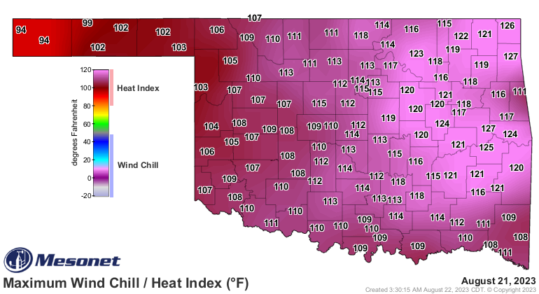
https://ticker.mesonet.org/archive/20230822/yesterdays-max-heat.index.png
https://ticker.mesonet.org/archive/20230822/yesterdays-max-dewpoint.png
WHATTTT? A double-breakage in the same day? That's not the Oklahoma weather I
know and love!
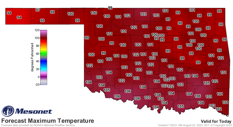
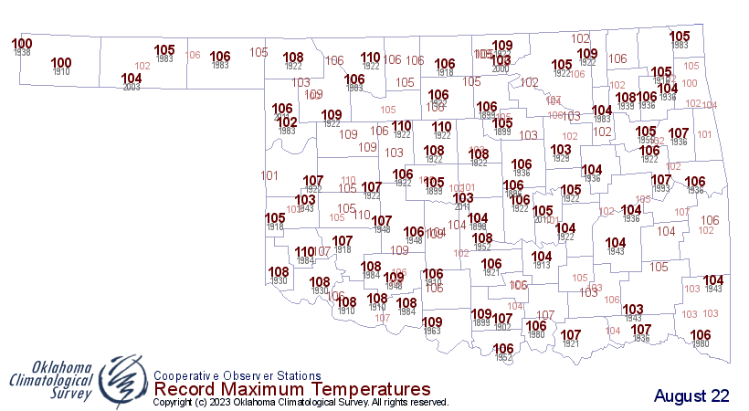
On top of that, we also saw some ACTUAL air temperature records fall in isolated
areas, but many were close to their all-time record highs for an Aug. 21 in
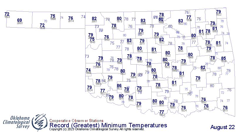
Oklahoma, as has happened for days now. AND we saw some record high Tmins
fall in isolated areas this morning as well. ANNNNDDDDD we should watch for some
more record highs today as well.
I like "as well."
https://ticker.mesonet.org/archive/20230822/todays-lows.png
https://ticker.mesonet.org/archive/20230822/aug22-record-hi-tmins.png
https://ticker.mesonet.org/archive/20230822/todays-forecast-highs.png
https://ticker.mesonet.org/archive/20230822/aug22-record-highs.png
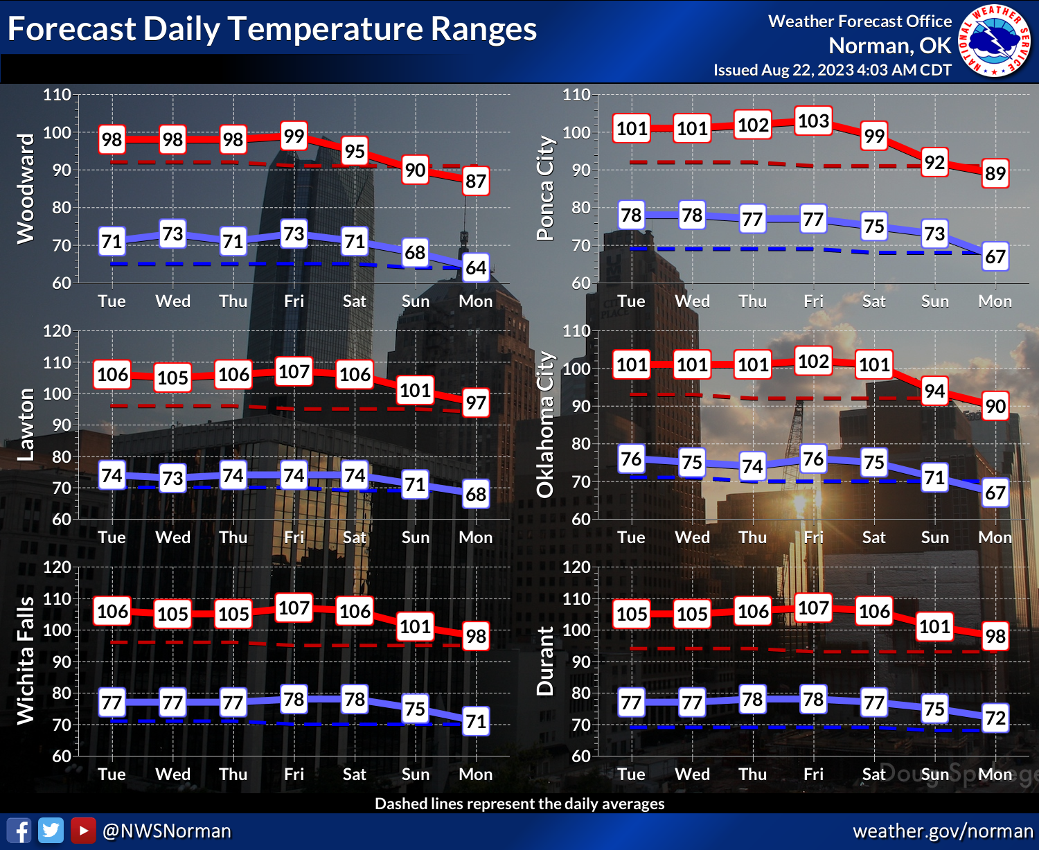
Now it does look like that front will indeed make it down into Oklahoma as we
get later into the weekend and cool us down to more seasonable levels for a few
days. We might go right back into the heat if the high pressure dome moves
back over us, but a break will be much welcomed.
https://ticker.mesonet.org/archive/20230822/nws-norman-7day-temps.png
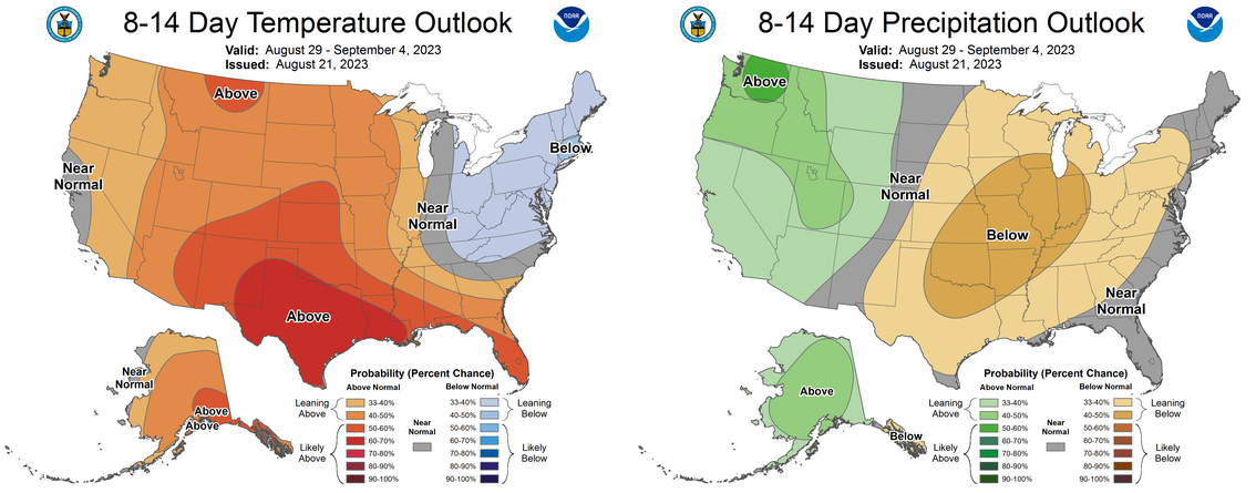
https://ticker.mesonet.org/archive/20230822/aug29-sept4-outlooks.png
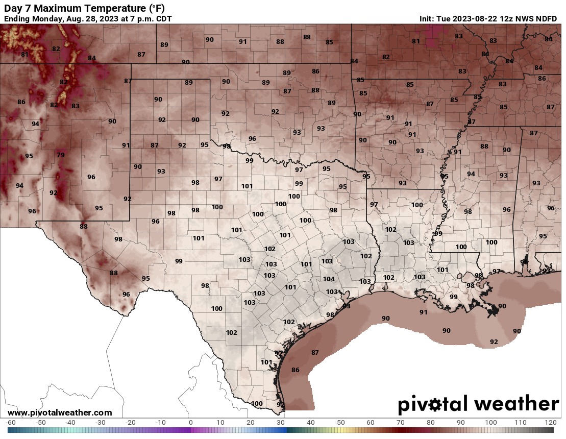
90s, anyone? Break out your Beanie Babies and go get a Rachel haircut...they're
coming!
https://ticker.mesonet.org/archive/20230822/monday-forecast-highs.png
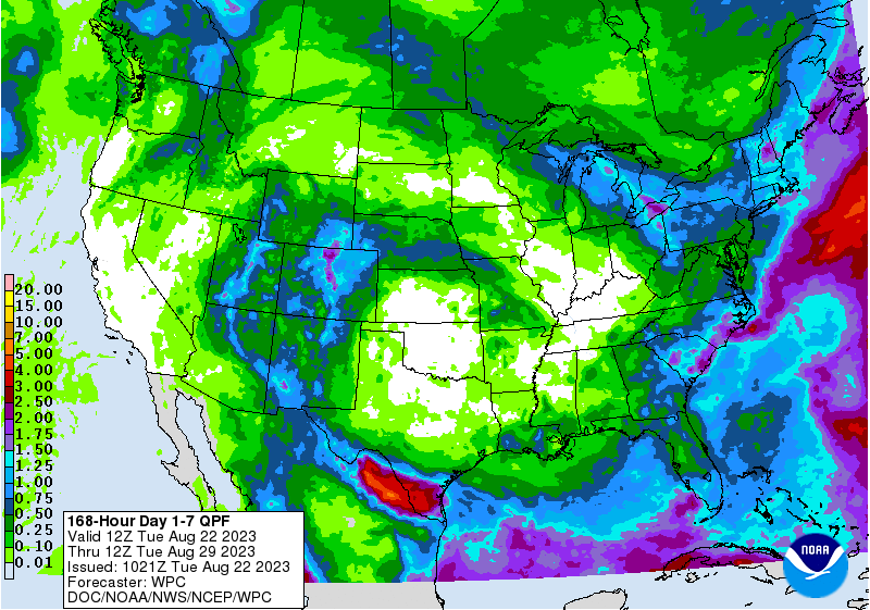
Not sure about the rain, though.
https://ticker.mesonet.org/archive/20230822/7day-rain-forecast.gif
Gary McManus
State Climatologist
Oklahoma Mesonet
Oklahoma Climatological Survey
gmcmanus@mesonet.org
==================================================
The OCS/Mesonet Ticker
https://ticker.mesonet.org/
To subscribe or unsubscribe from the Ticker
or for questions about the Ticker or its content
Phone or Email the Ticker Manager at OCS
Phone: 405-325-2253 Email: ticker@mesonet.org
---------------------------------------------------
-C- Copyright 2024 Oklahoma Climatological Survey
===================================================
|


 Tweet
Tweet