MESONET TICKER ... MESONET TICKER ... MESONET TICKER ... MESONET TICKER ...
September 21, 2023 September 21, 2023 September 21, 2023 September 21, 2023
Gosh Wally that's a lot of rain
https://ticker.mesonet.org/archive/20230921/tropic-of-beaver.png
You see, kids, back in the late 1950s and early 1960s, there was a television
show about a wholesome family (they all were back then), the Cleavers. There was
the dad, Ward, and the Mom, Mom. June, maybe? Then there was oldest son Wally
and the titular Beaver. Beaver Cleaver. Of course, Beaver would go on to be named
Beaver THE Cleaver for his favorite instrument of terror. A famous drunkard,
Beaver was known to frequent the local tavern and make ill-timed jokes about
meteorologists. "They just flip a coin!" he would jest about their forecasting
skills. Nobody thought that was funny. Everybody knew that meteorologists were
perhaps the most beloved profession in the land. But then the Cleaver would come
out with the threat of "laugh...or else." The awkward chuckles did little to belay
the Cleaver's anger.
"From this point forward, if somebody tells a joke about a meteorologist, there
had better be laughter or I'll come back. Come back from the dead if I have to,
and make people pay," he promised with an evil glint in his eye. Turns out the
glint was actually just lint from doing his laundry earlier, but that's not
pertinent to the story. I don't know if that unnecessary "g" tacked onto the front
of "lint" would change anything, but what I do know is that from that point
forward, jokes about the weather profession have been laughed at out of fear
rather than humor. The only thing LESS funny are jokes about weather people that
have lost their hair, but I digress.
So make those jokes about us weather folk, and laugh if you must, and indeed
you must, because if you forget, just remember to look behind you on that dark
night walking alone. Check that bathroom mirror late at night when you flip
the lights on. Be wary of what's on the other side of that refrigerator door.
Because you know what will be waiting.
The Cleaver.
Well I had to write something whilst waiting for the new SPC outlook maps to
come out, didn't I?? More on that down below, but since we're talking about
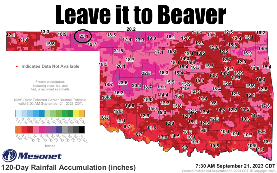
Beaver... it is very strange to have a Panhandle location lead
the state in rainfall for an extended period of time. Maybe over a week or two.
MAYBE. But over a 120-day span? I'd say unheard of, and I've heared (yes...
heared) Oklahoma weather for decades. But there's Beaver with 25.1 inches of
rain over the last 120 days. That total is a whopping 14.8 inches above normal
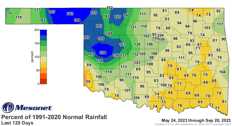
over that May 24-Sept. 20 stretch, or 243% of normal. So normal is right around
10.3 inches.
https://ticker.mesonet.org/archive/20230921/del120day_rain.current.png
https://ticker.mesonet.org/archive/20230921/pct120day_rain.current.png
https://ticker.mesonet.org/archive/20230921/nor120day_rain.current.png
Heck, there have been sprinkles up that way this morning, for crying out loud!
https://ticker.mesonet.org/archive/20230921/current-radar.png
How much rain is that for Beaver?
* Beaver's wettest May 24-Sept. 20 on record previous to this year was 22.75"
from 1968, and those records date back to 1896!
* Their wettest 120-day stretch on record (any 120-day stretch) is 27.34" from
May 6 through June 2, again from 1968, so a little more than 2" behind that
previous record.
Maybe that was another year Beaver led the state for that 120-day period? Well,
no. There were three sites ahead of them, led by Carter Tower's 30.62", down
by Ardmore.
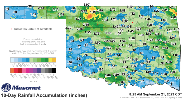
But just over the last 10 days, since we've started to see rain again, Beaver
has upped their total by more than 3", while other parts of the state have
seen less than a half-inch.
https://ticker.mesonet.org/archive/20230921/10day-rain-totals.png
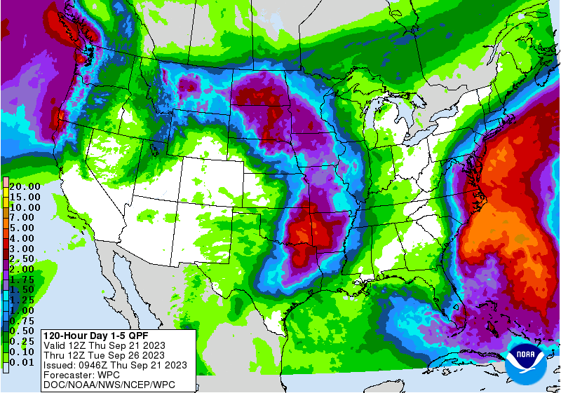
What about coming up? Well, somebody might finally pass Beaver's total with lots
of rain being forecast for eastern OK. A bit more for western OK and the
Panhandle, but not nearly as much.
https://ticker.mesonet.org/archive/20230921/5day-rain-forecast.gif
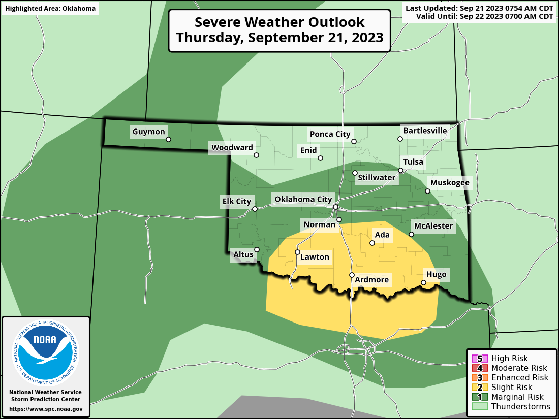
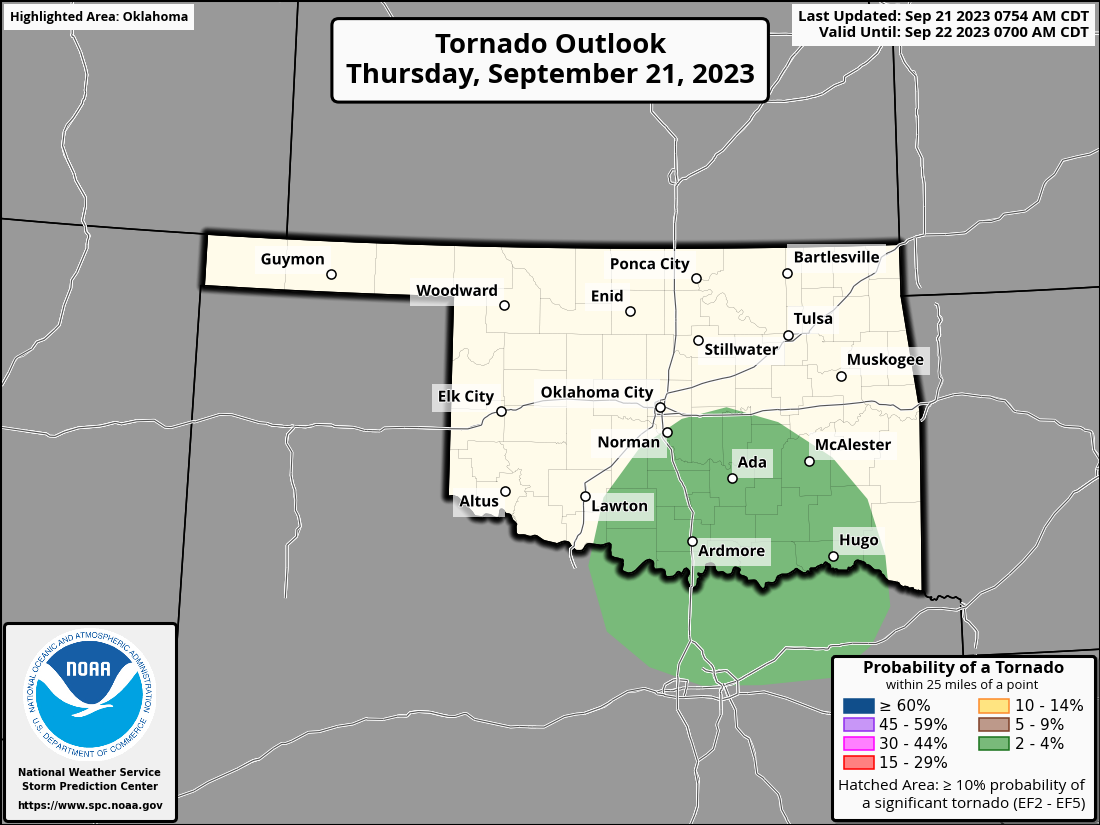
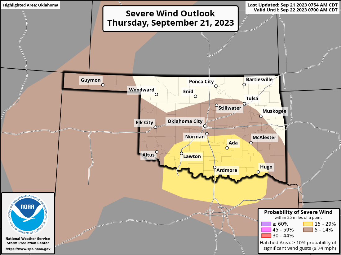
And a good bit of that will fall today and into tonight with a threat of
severe weather down in southern OK.
https://ticker.mesonet.org/archive/20230921/OK_swody1.png
https://ticker.mesonet.org/archive/20230921/OK_swody1_TORN.png
https://ticker.mesonet.org/archive/20230921/OK_swody1_WIND.png
https://ticker.mesonet.org/archive/20230921/OK_swody1_HAIL.png
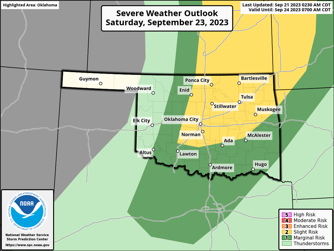
Best to stay weather aware today, and then again on Saturday, for those severe
threats (ARE THERE ANY OTHER KIND??).
https://ticker.mesonet.org/archive/20230921/OK_swody3.png
Another Oklahoma hazard continues to strengthen despite all the rain. The drought,
with the flash variety across much of the SW half of the state, and the long-term
type in far north central and southwestern OK. In fact, the amount of drought
considered at least extreme (D3) on the Drought Monitor map jumped from 3.5%
last week to 12.2% this week, all across southern OK.
https://ticker.mesonet.org/archive/20230921/20230919_ok_trd.png
So that rainfall maximum being forecast (don't laugh...or do I guess) down in
that part of the state will come in handy if it comes to fruition. And things
are looking up from there. We see increased odds of above normal precipitation
as we get out into early October from the CPC outlooks.
https://ticker.mesonet.org/archive/20230921/sept28-oct4-outlooks.png
Then when we get out to the October and October-December time frames, we start
to see that familiar El Nino signal start to creep in. As noted by the CPC
seasonal outlook forecast:
"The most recent International Research Institute for Climate and
Society (IRI) plume indicates El Nińo will persist through the Northern
Hemisphere winter 2023-24. Despite nearly the same ensemble mean
amplitude as last month, the shorter forecast horizon means that the odds
of a "strong" El Nińo (≥1.5°C for the November-January seasonal average
in Nińo-3.4) have increased to 71%. In summary, El Nińo is anticipated to
continue through the Northern Hemisphere winter (with a greater than 95%
chance through JFM 2024)."
https://ticker.mesonet.org/archive/20230921/CPCoff_ENSOprobs_092023.png
https://ticker.mesonet.org/archive/20230921/ENSO-probs.png
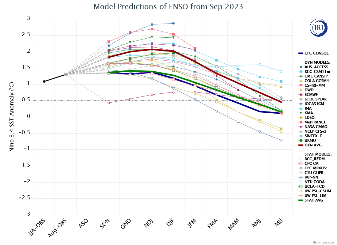
https://ticker.mesonet.org/archive/20230921/model-predictions-of-ens.png
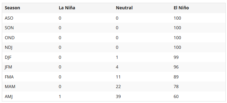
In this table, you can see the probabilities of the strength of the El Nino
as we go through the 3-month periods, peaking at 73% in the Oct-Dec time frame.
https://ticker.mesonet.org/archive/20230921/ENSO-strength.PNG
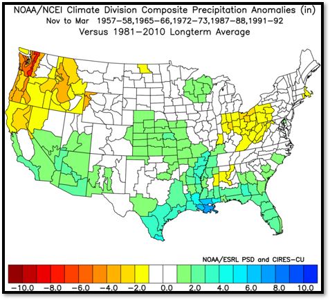
And remember, the strength of the El Nino doesn't mean stronger impacts, it means
that the typical impacts are more likely. For us, we look back to how strong
and super-strong ( < -2C) events have impacted us.
https://ticker.mesonet.org/archive/20230824/strong-el-nino-precip.png
https://ticker.mesonet.org/archive/20230824/super-strong-el-nino-precip.png
But let's get to the outlooks!
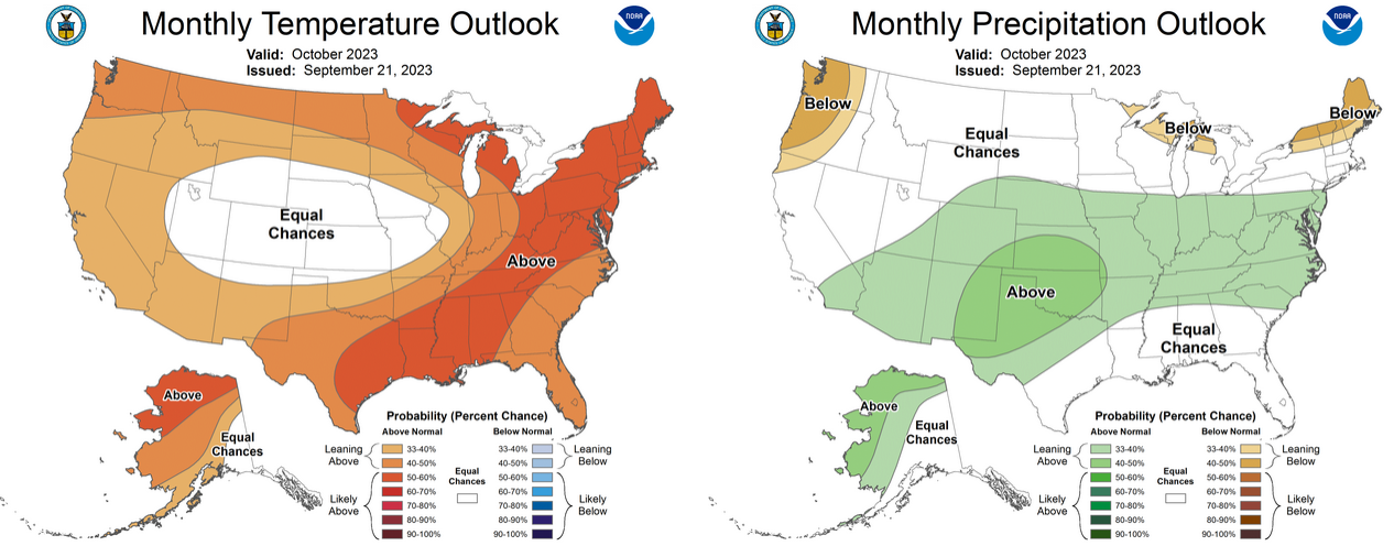
October:
https://ticker.mesonet.org/archive/20230921/October-outlook.png
And then October-December:
https://ticker.mesonet.org/archive/20230921/october-december.png
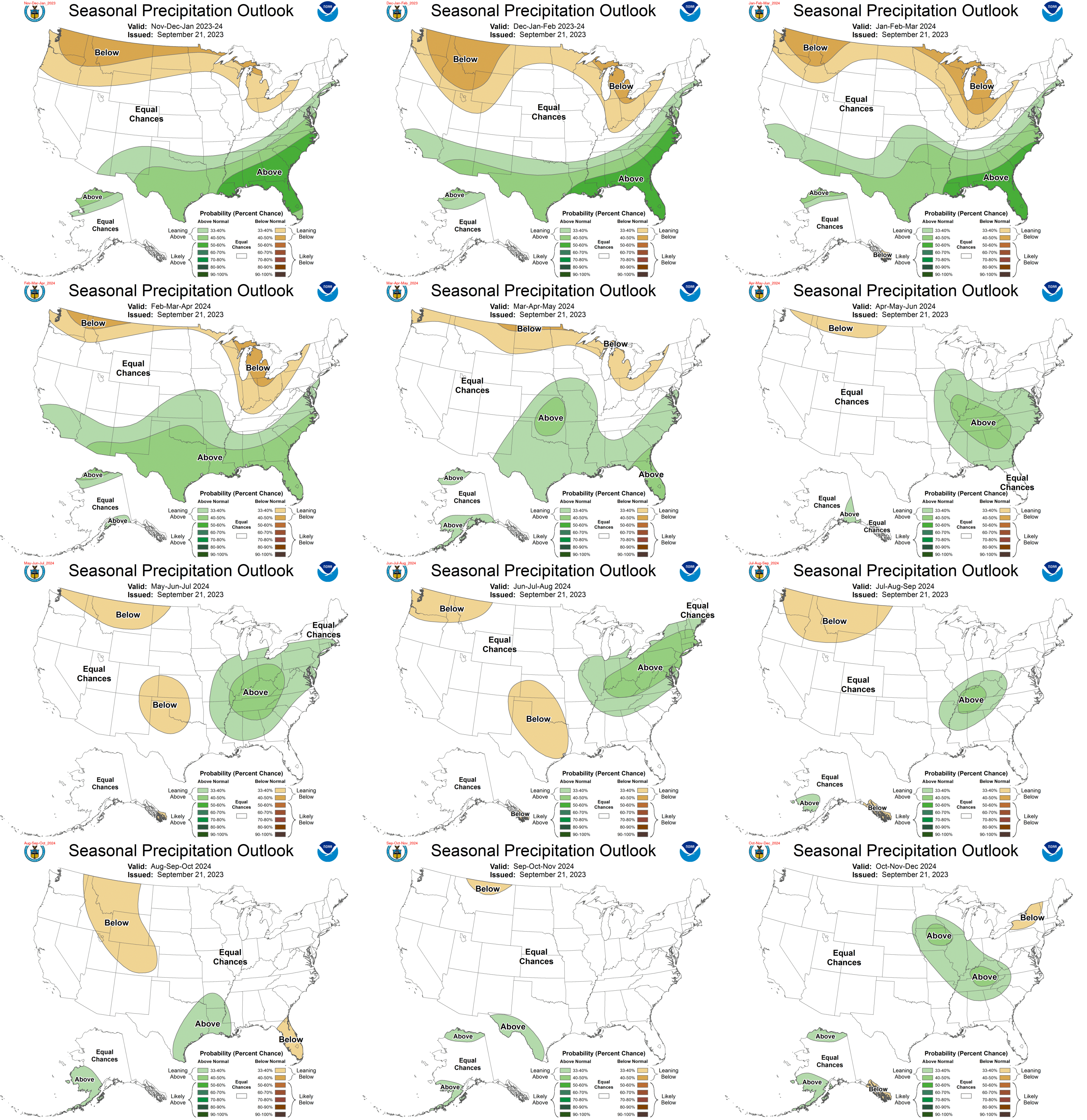
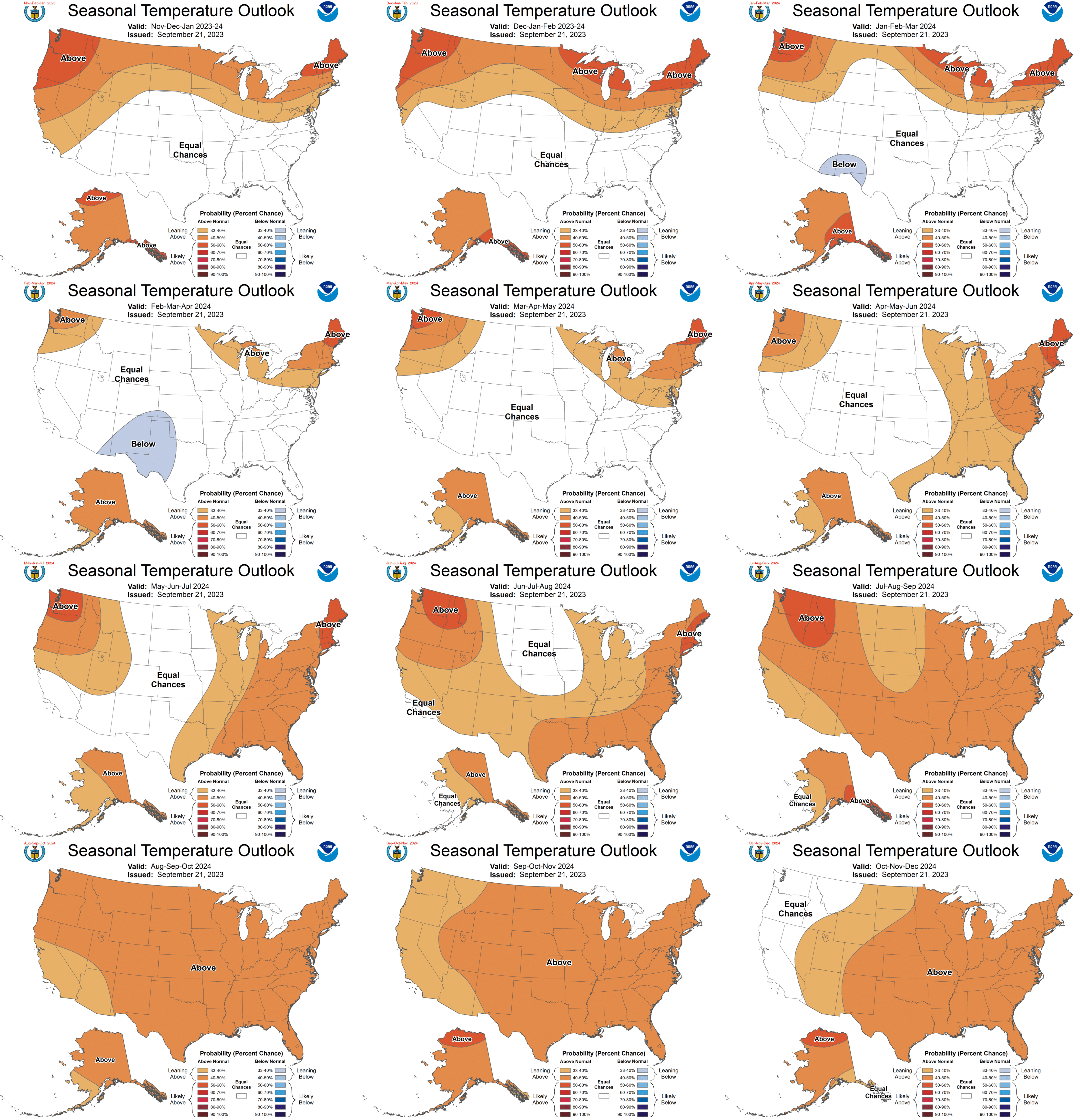
Very nice! But as noted, ENSO impacts extend out to spring after peaking during
winter, so those later outlooks are pertinent here as well.
https://ticker.mesonet.org/archive/20230921/all-precip-outlooks.gif
https://ticker.mesonet.org/archive/20230921/all-temperature-outlooks.gif
Oof! Who else sees snow in those outlooks? I see snow. You want snow. I want
snow. We all want snow. Climatologically, this bears out for the western 2/3rds
of the state, at least, with increased snowfall more likely.
https://ticker.mesonet.org/archive/20230921/Snowfall_ElNinoComboMap_Lg.png
Surely those hopes will be dashed? Maybe not, and don't call me Shirley.
Gary "the Cleaver" McManus
State Climatologist
Oklahoma Mesonet
Oklahoma Climatological Survey
gmcmanus@mesonet.org
==================================================
The OCS/Mesonet Ticker
https://ticker.mesonet.org/
To subscribe or unsubscribe from the Ticker
or for questions about the Ticker or its content
Phone or Email the Ticker Manager at OCS
Phone: 405-325-2253 Email: ticker@mesonet.org
---------------------------------------------------
-C- Copyright 2024 Oklahoma Climatological Survey
===================================================
|


 Tweet
Tweet