Ticker for August 21, 2012
MESONET TICKER ... MESONET TICKER ... MESONET TICKER ... MESONET TICKER ...
August 21, 2012 August 21, 2012 August 21, 2012 August 21, 2012
Has drought turned the corner?
The early arrival of September-ish weather has improved, put a dent in,
and diminished the progression of drought in many parts of Oklahoma. Now what
category your area fits in depends on how much rainfall you received, but the
cooler weather has helped all categories. Now that the rains have taken a
hiatus for a few days, here's what the final tally looked like (Mesonet sites and
radar estimates from the RFC in Tulsa) since last week.
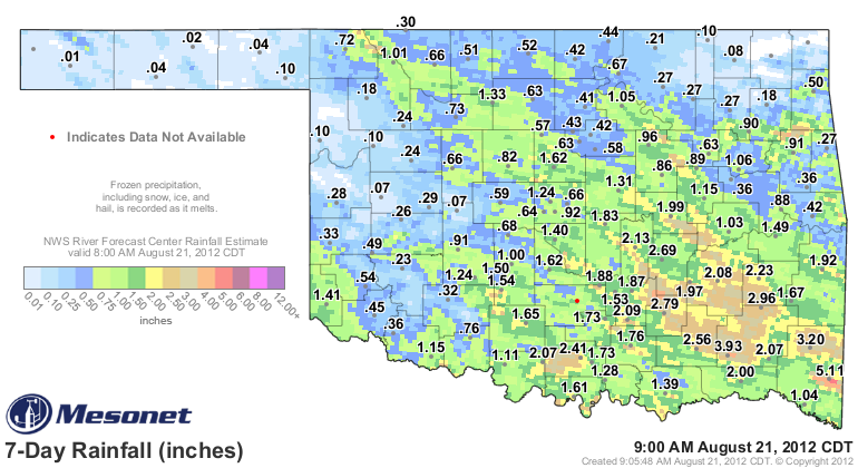
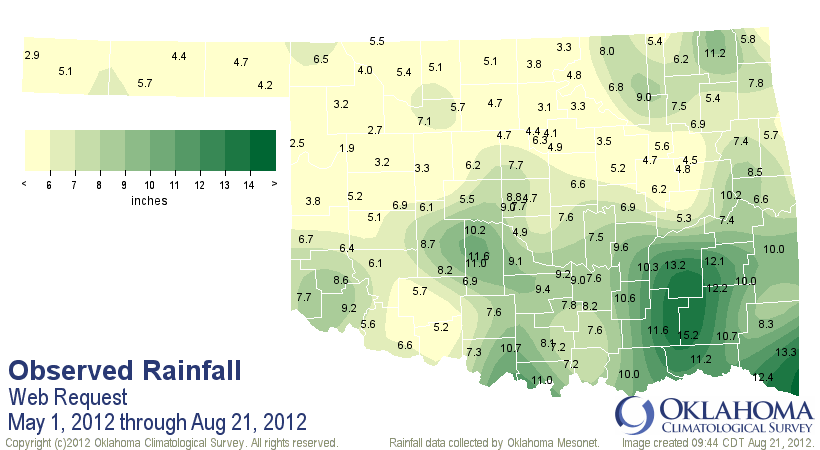
The most widespread beneficial rains fell down in southeastern Oklahoma with a
nice little area of 2-4 inches. A general area of 0.5-1.0 inches fell across much
of central Oklahoma, with some places receiving more, some receiving less. I think
it is safe to say that the southeast was one of the areas where drought improvement
was realized. The southwest got into the act last night with generally light rain
falling, but the extreme tip of that part of the state saw over an inch. The
Mesonet site at Hollis received a whopping 1.24 inches.
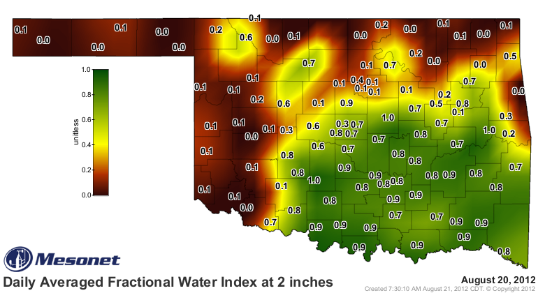
So how did all of this affect the drought? It's obvious that it improved things
in southeastern Oklahoma. A glance at the topsoil moisture data provides clues.
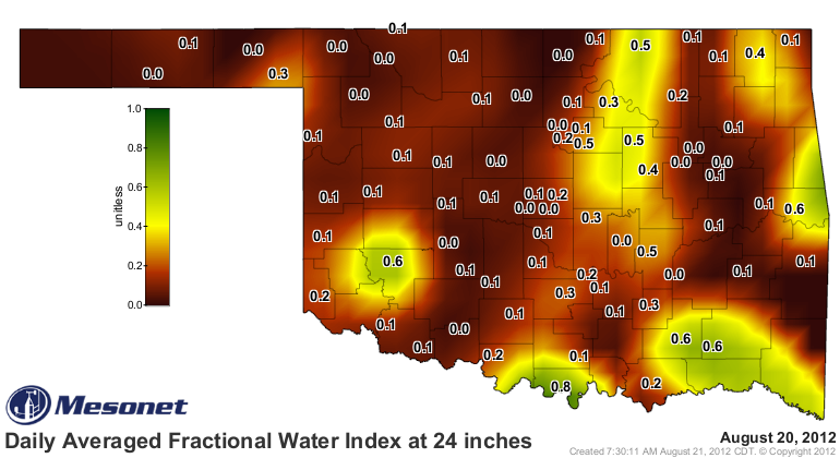
Go a bit farther down to the 10-inch and 24-inch soil moisture and the picture
becomes a bit more clouded (and dry).
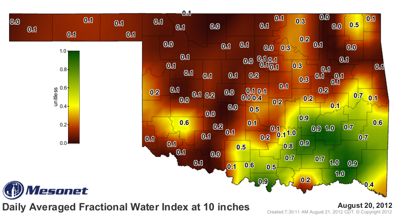
A modicum of improvement was seen down in southeastern and south central parts
at 10 inches, but very little of the recent moisture made it into the lower
depths. As we have talked about many times, relieving drought is a process.
The topsoils drank first and in some cases became saturated. Some percolated
down to the 10-inch soils, but nothing really made it past that point. And that
topsoil and 10-inch moisture is being worked on as we speak from above (by the
atmosphere), below, and by plants suddenly thinking it's okay to grow again.
Here are the things we'll be looking for as we assess the drought: rainfall,
obviously; soil moisture; lake levels; reports from the field; green-up.
Let's take a look at a test case in Norman, an area in exceptional drought that
had gone 70 consecutive days without at least a tenth of an inch of rainfall in
a single day. It received 1.4 inches of rain, which is more than they had
received the previous 78 days (May 30). The trouble is that still only leaves them
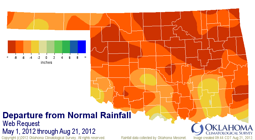
with 4.9 inches since May 1, and that's still a deficit of 6-8 inches. In fact,
most of the state remains from 2-8+ inches down since May 1. So the 1.4 inches
of rainfall is welcomed, but still a bit meager compared to the damage done
by the previous months and the extreme heat.
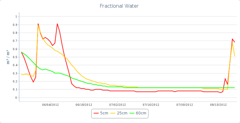
Soil moisture did improve at the 2-inch and 10-inch levels, but they are now
on their way back down with too much built-up demands to satisfy. The moisture
never reached the 24-inch level as evident by the flat green line. Reinforcing
moisture is needed to avoid the type of drop-off shown in June. At least there
will not be extreme heat (at least for awhile) to help facilitate that.
The reports from the field are not encouraging just yet, as evident from the
latest USDA Crop Weather Report from our friends over at the National Agric.
Statistics Service.
"Overall the rain was beneficial, but provided no significant
improvements to conditions. In most areas there was no run-off
to improve water availability for livestock, and hay supplies
from the spring were already being used to supplement the lack
of pasture. Producers continued culling herds and making difficult
decisions in the face of the ongoing drought. Temperatures were
significantly cooler than the previous week, with highs averaging
from the upper 80s to the low 90s. Ninety-seven percent of topsoil
was rated short to very short and subsoil moisture conditions
worsened over the past week to 98 percent rated short to very short."
I'm not sure of the dynamics of "waking up" natural grasses, but I would think
(DANGER!!) there is still plenty of time to see improvement of our pastures.
Unlike last year when the rains returned too late in October.
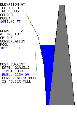
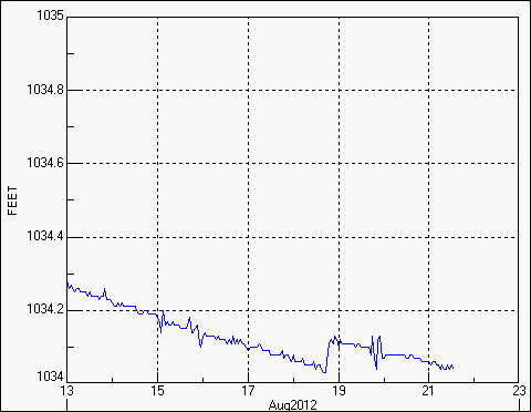
Lake Thunderbird, Norman's main water supply, did recover a bit ... all the way
back to the level it was at on, uhhh, August 16?? And on its way down it goes
once again. So little recovery there, and it once again sits at 74% of normal
still.
The green-up will take a bit of time. I can see with my own eyes a few more
shades of faint green amongst the yellows and browns. But given the right
conditions, fire danger will still be a problem. Other than the green trees,
which continue to drop leaves, we continue to look very January-ish around
these parts.
So those are some of the things we will be looking at as we assess the drought
conditions. The cool weather helps, but remember it's "relatively" cool weather.
Evaporation is still advanced in the upper 80s and lower 90s. I don't think it's
any secret that the Norman area will be remaining in the exceptional drought
category with limited relief of most of the known impacts. Other areas received
little-to-no rain and will be prospects for deterioration.
More rain is possibly on the way, which will help to reinforce what relief we
have seen. Relieving drought is a process. Maybe we've turned the corner just
a bit, at least for some.
Gary McManus
Associate State Climatologist
Oklahoma Climatological Survey
(405) 325-2253
gmcmanus@mesonet.org
August 21 in Mesonet History
| Record | Value | Station | Year |
|---|---|---|---|
| Maximum Temperature | 109°F | GRA2 | 2023 |
| Minimum Temperature | 48°F | EVAX | 2018 |
| Maximum Rainfall | 4.25 inches | RING | 2022 |
Mesonet records begin in 1994.
Search by Date
If you're a bit off, don't worry, because just like horseshoes, “almost” counts on the Ticker website!