MESONET TICKER ... MESONET TICKER ... MESONET TICKER ... MESONET TICKER ...
August 20, 2020 August 20, 2020 August 20, 2020 August 20, 2020
FIRE UP TROPICS!
http://ticker.mesonet.org/archive/20200820/invest97.png
To quote one of the great minds of the 20th century (I know, you're thinking I'm
going to say "ME!" but both my low self esteem and current lucid state prevents
that), and one of my personal heroes: "RUH RUH, RAGGY!"
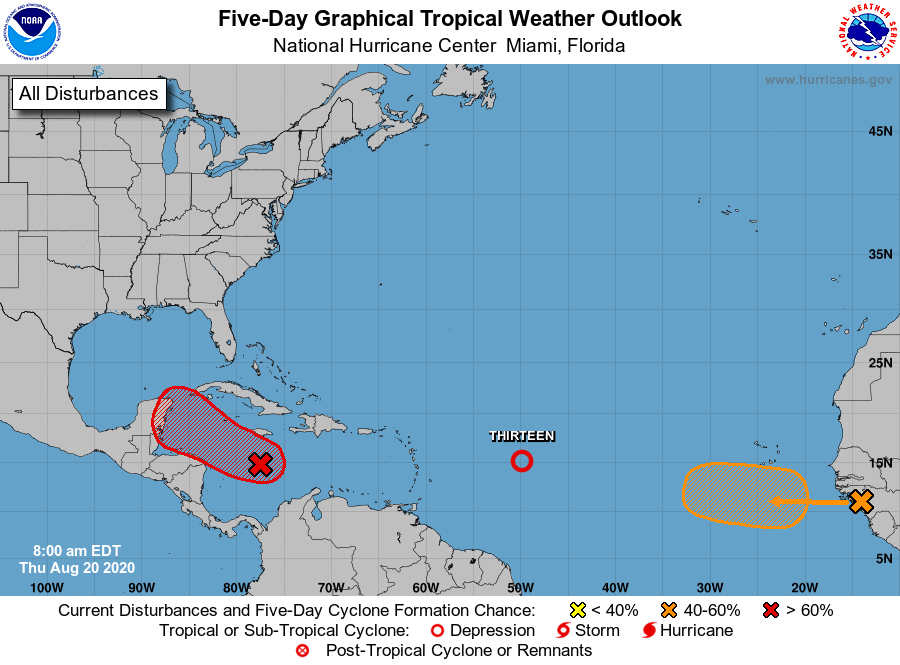
The tropics, as forecasters had predicted in their last outlook, have indeed
become active once again. There are now three areas of interest out there, with
the disturbance Invest 97 of particular interest to us here in the Southern
Plains.
http://ticker.mesonet.org/archive/20200820/tropical-outlook.png
Invest 97, interestingly the name of my garage band in high school, is being
given a 90% chance of tropical depression formation in the next 48 hours as it
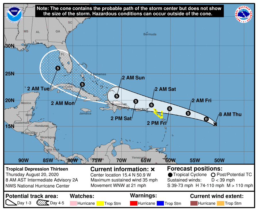
heads towards the Gulf Coast. Tropical Depression 13 (in an incredible double
coincidence, that was my nickname in college) is farther out and more of a threat
to Florida and the eastern Gulf Coast...but you never know.
http://ticker.mesonet.org/archive/20200820/TD13-cone.png
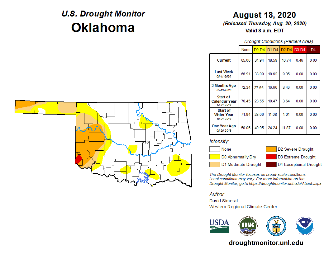
Now this all matters because of the possibility of Oklahoma being impacted by
the remnants of one of these systems. Some would welcome the visit (we see you,
western Oklahoma!), and others are saying "STAY AWAY!" We currently have an
intensifying drought situation once again across western Oklahoma, as evidenced
by the latest U.S. Drought Monitor map.
http://ticker.mesonet.org/archive/20200820/20200818_OK_trd.png
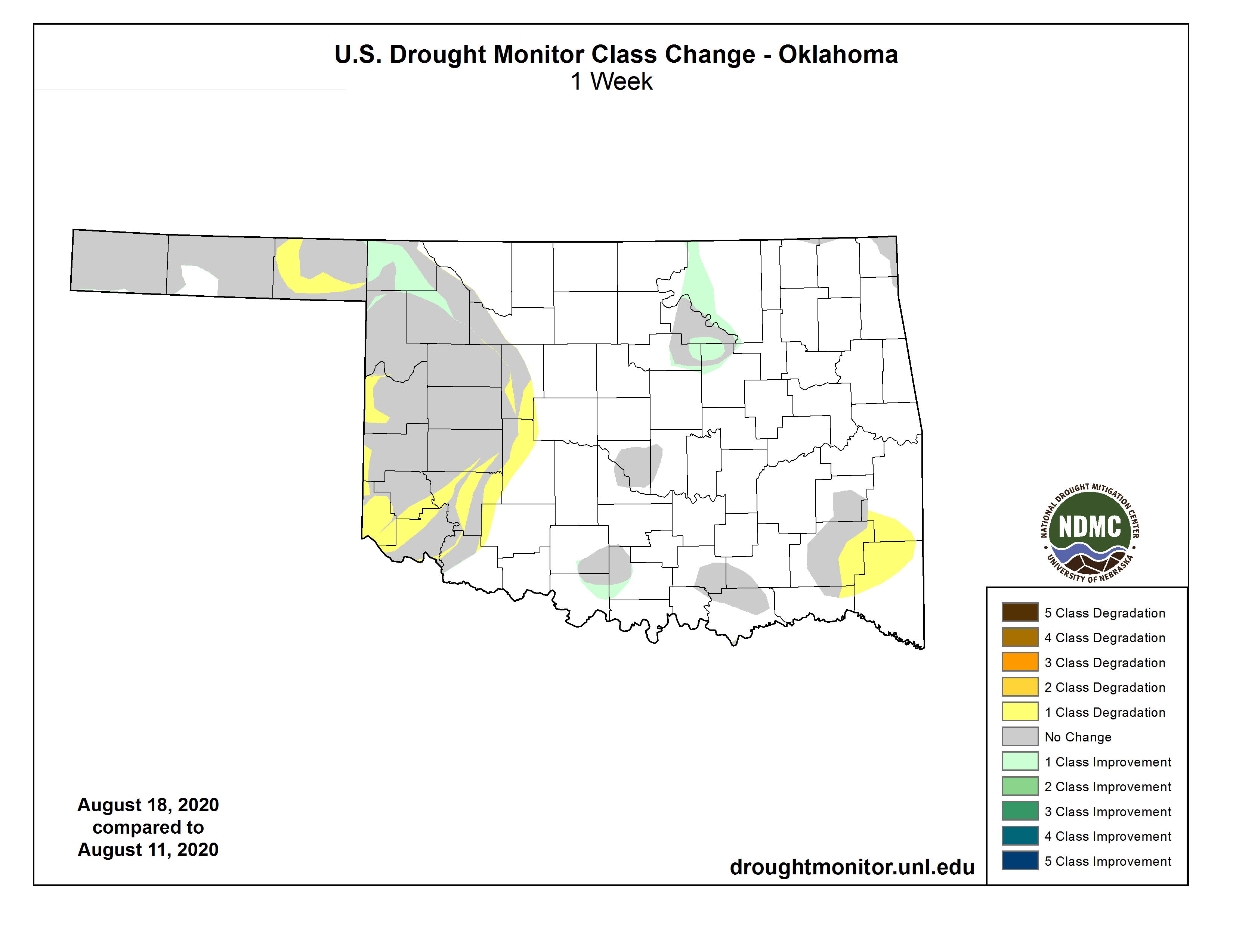
http://ticker.mesonet.org/archive/20200820/1week-change-DM.png
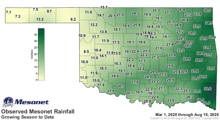
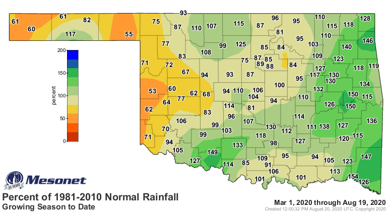
For today's Whack-A-Drought map choice, we'll show you the growing season
maps, which show what's been happening since March 1.
http://ticker.mesonet.org/archive/20200820/grow.meso.png
http://ticker.mesonet.org/archive/20200820/grow.norm_dep.png
http://ticker.mesonet.org/archive/20200820/grow.norm_pct.png
Not coincidentally, that's the area of the state that has seen most of the
extreme heat this year. Now this is also the climatological norm for our state,
but I think the dry conditions have helped it along this summer.
http://ticker.mesonet.org/archive/20200820/tmax.ge90.png
http://ticker.mesonet.org/archive/20200820/tmax.ge100.png
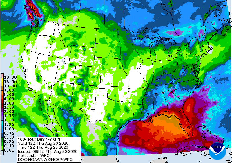
None of the tropical activity is showing up along the Texas Gulf Coast yet, at
least inland since the forecasts for the system's movement is still uncertain
up to that point. So our 7-day rain forecast is looking pretty bleak, but this
could change in a hurry if those models start to get a good handle on the
tropical system!
http://ticker.mesonet.org/archive/20200820/7day-rain-forecast.gif
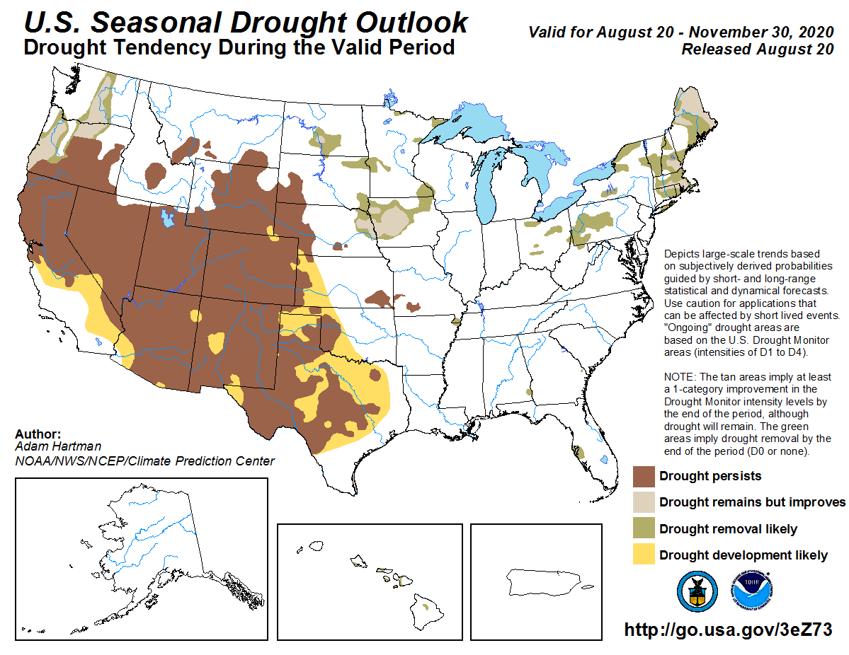
We're gonna need some help here. CPC has a dim view of western Oklahoma's
drought relief chances through the end of November.
http://ticker.mesonet.org/archive/20200820/sept-nov-drought-outlook.png
Their September outlooks are dominated by that large area of high pressure to
our west that is bringing extreme heat and wildfires across the West. That
area bleeds into western Oklahoma.
http://ticker.mesonet.org/archive/20200820/sept-temp-outlook.gif
http://ticker.mesonet.org/archive/20200820/sept-precip-outlook.gif
Remember, these maps show odds of above-, below- and near-normal conditions.
And the EC stands for Equal Chances of each of those categories. It is not a
forecast of "Normal."
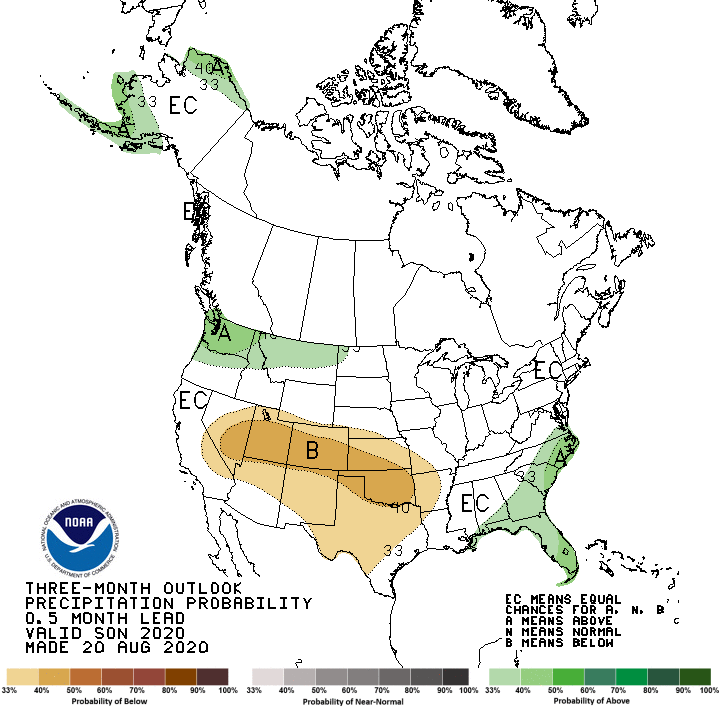
The 3-month outlooks for the Sept-Nov period are probably even worse, given
the area of enhanced probabilities for below normal precip across much of the
state.
http://ticker.mesonet.org/archive/20200820/sept-nov-temp-outlook.gif
http://ticker.mesonet.org/archive/20200820/sept-nov-precip-outlook.gif
We've seen these maps turn out to be a bit off-base before. Heck, this summer
even. But we don't want these to come to fruition in particular. Not the time
to go into dry mode with intensifying drought already in place.
As a reminder, we are in a La Nina watch for this fall through winter, which
can lead to a warmer/drier cool season (think October-April or so). That would
not be good either. So lots of uncertainty still, but the outlooks are not in
our favor at this point.
FIRE UP TROPICS!
Gary McManus
State Climatologist
Oklahoma Mesonet
Oklahoma Climatological Survey
(405) 325-2253
gmcmanus@mesonet.org
==================================================
The OCS/Mesonet Ticker
https://ticker.mesonet.org/
To subscribe or unsubscribe from the Ticker
or for questions about the Ticker or its content
Phone or Email the Ticker Manager at OCS
Phone: 405-325-2253 Email: ticker@mesonet.org
---------------------------------------------------
-C- Copyright 2024 Oklahoma Climatological Survey
===================================================
|


 Tweet
Tweet