MESONET TICKER ... MESONET TICKER ... MESONET TICKER ... MESONET TICKER ...
July 17, 2023 July 17, 2023 July 17, 2023 July 17, 2023
Ma-ly? Ju-pril?
https://ticker.mesonet.org/archive/20230717/july1-16.rain.totals.png
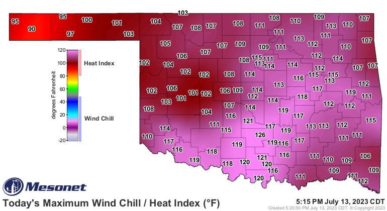
So a fella can't go relax on a beach in Florida without all summer breaking loose
back home I reckon? Who knew you could go go to a (check's notes) beach in Florida
to escape oppressive humidity.
https://ticker.mesonet.org/archive/20230717/july13-heat-index.jpg
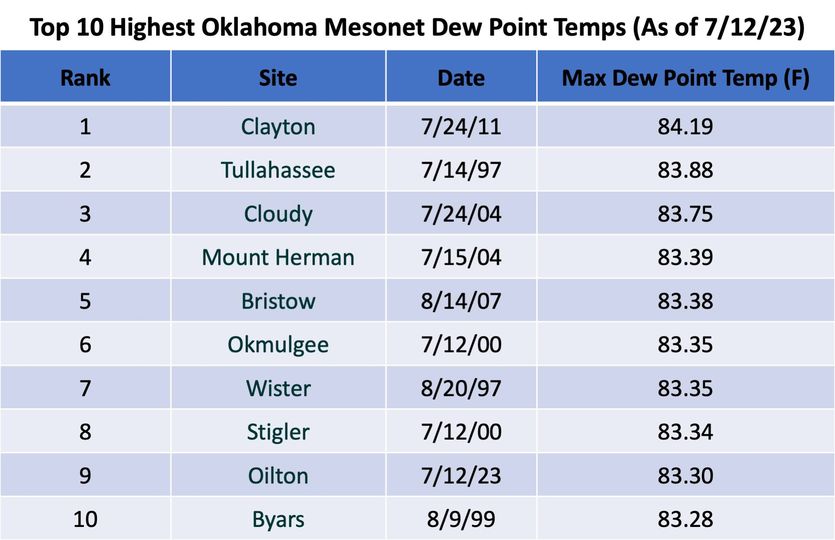
https://ticker.mesonet.org/archive/20230717/july13-max-dewpoints.png
https://ticker.mesonet.org/archive/20230717/mesonet-all.time-dewpoints.jpg
Darn, I was really upset to have missed those records whilst sipping my chocolate
milk and eating catfish caviar (we were on a budget) on the beach. Oh, and slip
Pauls Valley in there at #3 there on the list with a dewpoint of 83.8 degrees
on the 13th.
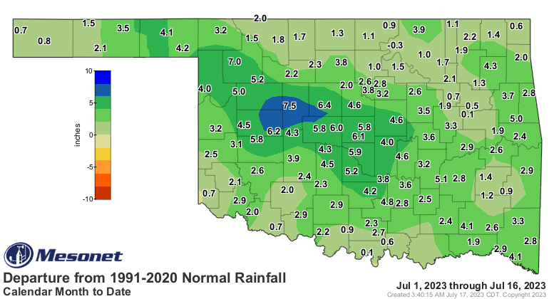
But back to that July rainfall, you can see that the rain isn't distributed very
evenly across the state. It *IS* Oklahoma, after all, but almost everybody has
had significant rain during what is normally the driest part of the warm season
here in Oklahoma. We see you, Hollis, Burneyville, Burbank, and the rest of you
folks with less than 2 inches. But let's all recognize Watonga's 8.93 inches,
and for being a whopping 7.5 inches above normal for the July 1-16 period!
https://ticker.mesonet.org/archive/20230717/delmonth_rain.current.png
https://ticker.mesonet.org/archive/20230717/pctmonth_rain.current.png
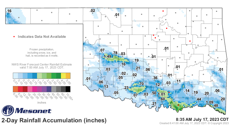
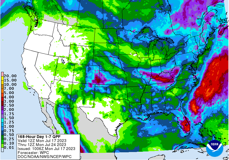
The rain has slowed considerably over the last few days, and more is on the way,
but it doesn't appear like those numbers are going to change as rapidly as
before.
https://ticker.mesonet.org/archive/20230717/rainrfc.48hr.png
https://ticker.mesonet.org/archive/20230717/7day-rain-forecast.gif
Before you ask...yes, I am the most handsome State Climatologist for Oklahoma
that we currently have. Sadly, also the ugliest. But also...no, we won't be
seeing our wettest July 1-31 on record. That belongs to July 1950 an its whopping
9.07 inches. Our statewide average of 4.56 inches is only good for the 19th
wettest July (if it ended today, and wouldn't we all be sad?).
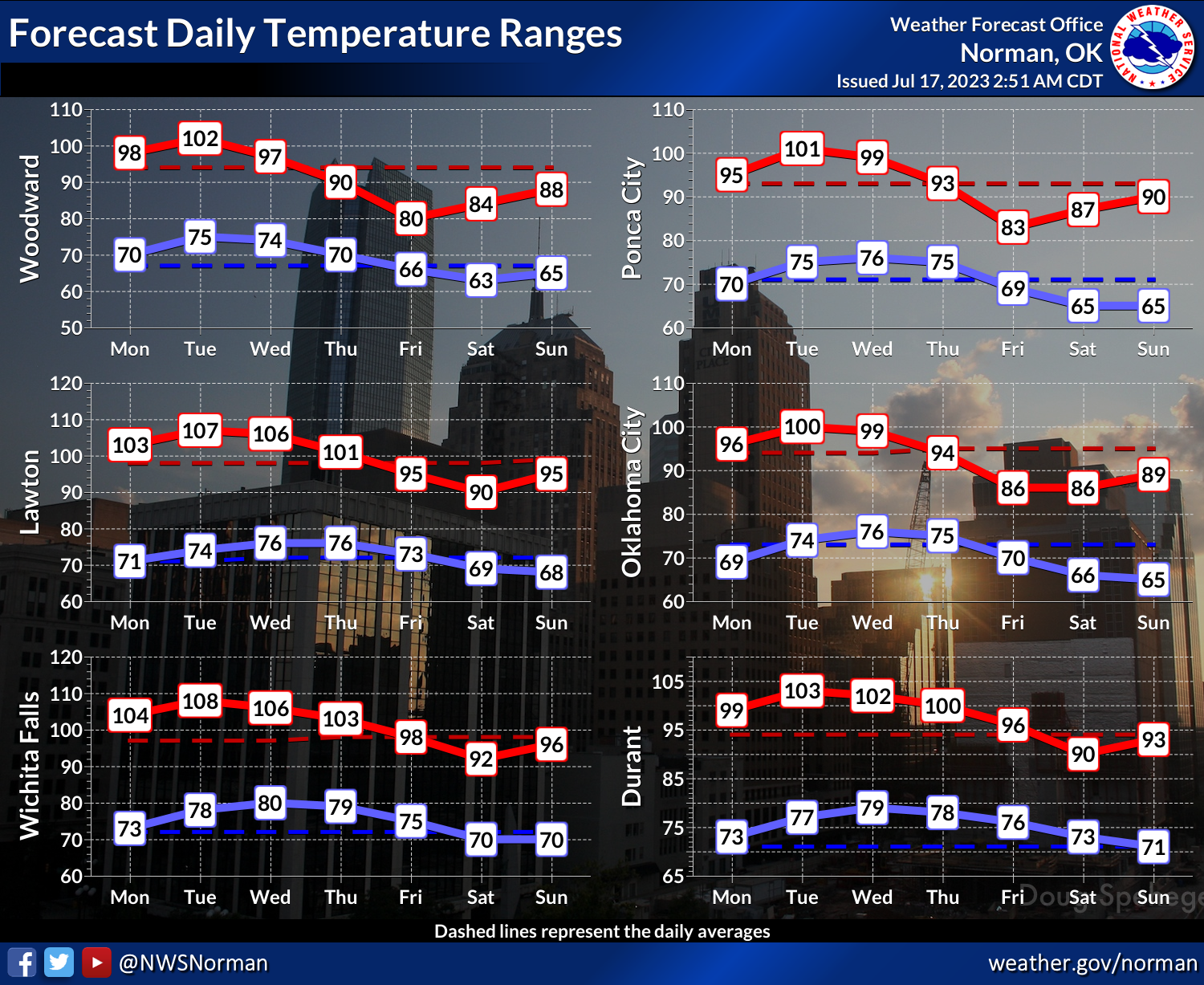
While our rain has slowed down, our heat is picking back up. Watch out for heat
index values of 105-110+ degrees over the next few days.
https://ticker.mesonet.org/archive/20230717/latest.oklahoma.heat.gif
https://ticker.mesonet.org/archive/20230717/nws-norman-monday.heat.png
https://ticker.mesonet.org/archive/20230717/nws-norman-tuesday.heat.png
https://ticker.mesonet.org/archive/20230717/nws-tulsa-heat.png
https://ticker.mesonet.org/archive/20230717/nws-shreveport-heat.png
But all eyes are on this weekend, when we should see a pretty substantial cold
front for late July.
https://ticker.mesonet.org/archive/20230717/nws-norman-7day-temps.png
80s? IN JULY?? Bah! Oh well, some of you will love that, if'n your of the
cooler-is-better persuasion. At least it's not dewpoints!
Gary McManus
State Climatologist
Oklahoma Mesonet
Oklahoma Climatological Survey
==================================================
The OCS/Mesonet Ticker
https://ticker.mesonet.org/
To subscribe or unsubscribe from the Ticker
or for questions about the Ticker or its content
Phone or Email the Ticker Manager at OCS
Phone: 405-325-2253 Email: ticker@mesonet.org
---------------------------------------------------
-C- Copyright 2024 Oklahoma Climatological Survey
===================================================
|


 Tweet
Tweet