Ticker for June 17, 2011
MESONET TICKER ... MESONET TICKER ... MESONET TICKER ... MESONET TICKER ...
June 17, 2011 June 17, 2011 June 17, 2011 June 17, 2011
Southwest OK's bad fortune
You would think Mother Nature would show a bit of mercy on southwestern Oklahoma
by now. If she's going to whip up a thunderstorm that produces severe winds of
up to 80 mph last night for a couple of hours, she could at least throw in some
hefty rain totals too.
Station Wind Gusts Date Time
Medicine Park 80 mph 9:00 PM
Grandfield 71 mph 9:40 PM
Altus 64 mph 8:15 PM
Altus 61 mph 8:05 PM
Medicine Park 60 mph 8:55 PM
Altus 60 mph 8:25 PM
Altus 60 mph 8:20 PM
Altus 59 mph 8:10 PM
Altus 59 mph 8:00 PM
Medicine Park 58 mph 9:05 PM
Medicine Park 58 mph 8:50 PM
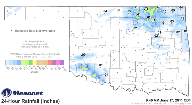
From the radar estimates, it appears there were totals of up to an inch or so
in very localized areas. I think I can speak for those areas down there in
saying "we'll take it!", however. More widespread rains in the northeast were
very much welcomed as well.
The story today will be the heat and fire danger once again. This is getting
old (aren't we all?), but seemingly like every day, the low temperatures across
much of Oklahoma neared or exceeded their record warmest levels this morning:
records: 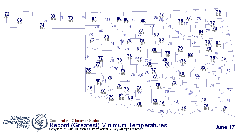
actuals: 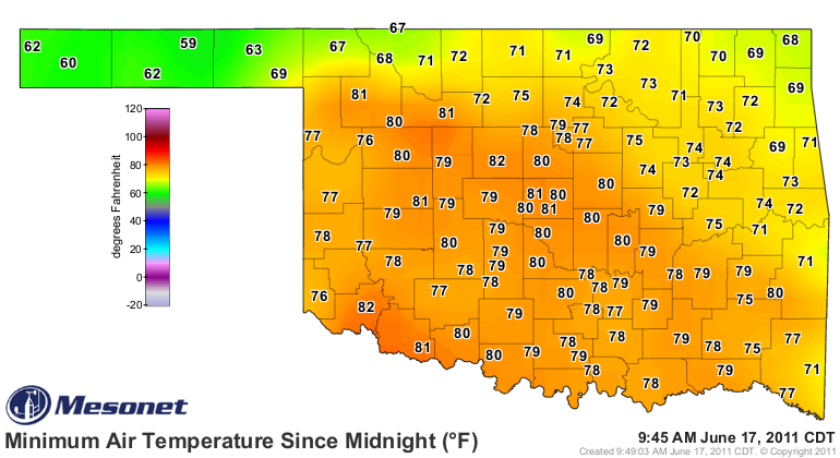
Altus was rewarded for missing the rain and getting pounded with severe winds
for over an hour with a low of ... 82 degrees? COME ON!
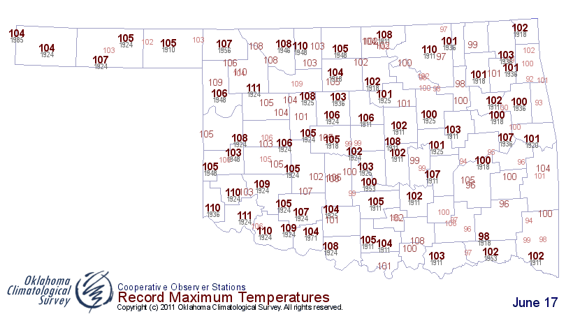
Keep track on the Mesonet today ... some of these record highs are bound to
fall.
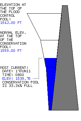
Speaking of Altus, Altus Lake is in sorry shape. As of this morning, its
elevation is 1539.75 feet, which is 33.36% of the conservation pool. It
is going to be a very bad summer down there if they don't get a bunch of
rainfall in Lake Altus' watershed. Here's a graphic of the somewhat graphic
situation down there from the Tulsa Corps of Engineers.
*********************************************************************
Here's an interesting tidbit from a U.S. Drought Monitor discussion:
"105?F on June 15 in Tallahassee, FL. Prior to June 15, 2011,
Tallahassee?s temperature had never been above 104?F. June 29, 1931,
was the date of Florida?s highest verified temperature on record:
109?F in Monticello, about 25 miles east-northeast of Tallahassee.
Florida is only one of ten states (along with Alaska, Hawaii, and
eight Northeastern States ? CT, ME, MD, MA, NH, NY, RI, and VT) to
have never hit 110?F."
This exemplifies the power of living next to an ocean and its modifying
moisture. We don't want to compare heat indices, I'm betting. But, it's hot
all over. Heck, I'll bet somewhere in Oklahoma hits 110 degrees today. It's all
relative, I reckon.
My advice, find a nice pool to jump in. Or a pond ... pond be good for you.
Gary McManus
Associate State Climatologist
Oklahoma Climatological Survey
(405) 325-2253
gmcmanus@mesonet.org
June 17 in Mesonet History
| Record | Value | Station | Year |
|---|---|---|---|
| Maximum Temperature | 114°F | GRA2 | 2011 |
| Minimum Temperature | 45°F | BEAV | 1999 |
| Maximum Rainfall | 10.49 inches | NEWP | 2015 |
Mesonet records begin in 1994.
Search by Date
If you're a bit off, don't worry, because just like horseshoes, “almost” counts on the Ticker website!