MESONET TICKER ... MESONET TICKER ... MESONET TICKER ... MESONET TICKER ...
October 16, 2023 October 16, 2023 October 16, 2023 October 16, 2023
Freeze-dried
https://ticker.mesonet.org/archive/20231016/7day-rain-forecast.png
Don't look now...I SAID DON'T LOOK NOW, YA WEIRDOS! I'm changing (into what I have
no idea). Just bringing out the sweaters, coats and jackets from the attic since
we've transitioned to winter what with all the freez...wait wait wait. Hold on.
https://ticker.mesonet.org/archive/20231016/nws-norman-7day-temps.png
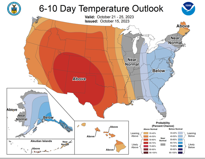
https://ticker.mesonet.org/archive/20231016/oct21-25-temp-outlook.png
Dad-blast-it (Okie to English translation: #@&%*)! Okay, how about we put those
sweaters on stand-by for the next couple of days. Coats...back on the top rack.
Jackets...keep 'em down. We have another cold morning to go.
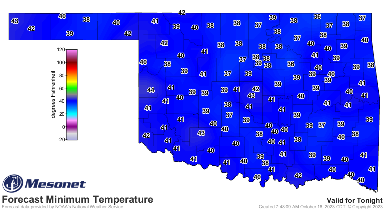
https://ticker.mesonet.org/archive/20231016/tuesday-morning-lows.png
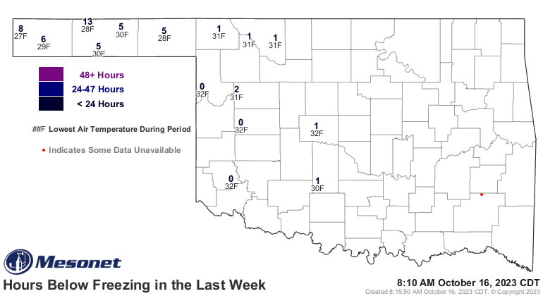
Now that we've had 15 Mesonet sites officially hit the freezing mark, we can
officially think about those closet changes.
https://ticker.mesonet.org/archive/20231016/cumulative.freeze.168hr.gif
Our El Reno site had a freeze this morning, of course. Whoa, Acme too? Mangum??
You've got to be kidding me, Mangum! What do you think you are, some kind of
Panhandle site??
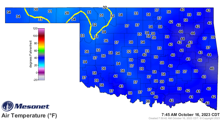
Freeze? Heck, it's freezing right now for crying out loud!
https://ticker.mesonet.org/archive/20231016/current-temps.png
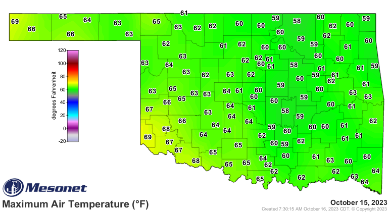
This has been quite a cold snap. Yes, COLD. Yesterday was the first day we
failed to reach a high in at least the 70s in the state since April 26. Hollis
and Kenton got close at 69 degrees.
https://ticker.mesonet.org/archive/20231016/yesterdays-highs.png
Back to rainfall (you can look now), it's looking pretty desperate right now
after that mostly dry cold front scoured the moisture from the air all the way
to the Gulf. We're building on yet another month-long (plus) dry spell, which
is very bad news for our drought-plagued state.
https://ticker.mesonet.org/archive/20231016/mesonet.rainfall.tenthinch.png
https://ticker.mesonet.org/archive/20231016/mesonet.rainfall.quarterinch.png
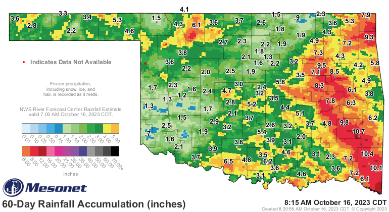
Our flash drought is now somewhere close to 87 days (unofficial official starting
date of July 21), so we look to the 60-day maps one more time to catch the
depths of it before it starts showing up on our 90-day maps.
https://ticker.mesonet.org/archive/20231016/60day-rain-totals.png
https://ticker.mesonet.org/archive/20231016/pct60day_rain.current.png
https://ticker.mesonet.org/archive/20231016/del60day_rain.current.png
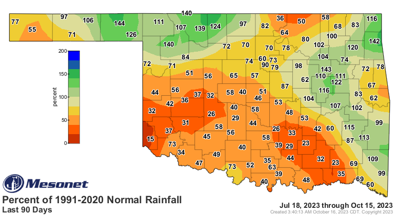
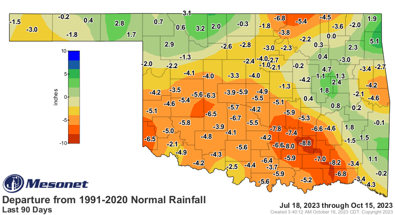
Although those 90-day maps ain't looking so great themselves.
https://ticker.mesonet.org/archive/20231016/pct90day_rain.current.png
https://ticker.mesonet.org/archive/20231016/del90day_rain.current.png
Where's out next rain coming from? Well, not all doom and gloom, with another
possible storm system coming our way next week from up in the Gulf of Alaska,
AND maybe from the south as well? There's a tropical system down off the west
coast of Central America thinking it wants organize into a tropical storm
or hurricane in the next few days.
https://ticker.mesonet.org/archive/20231016/pacific-outlook.png
Some of the forecast models have it headed up our way later into the middle of
next week. It wouldn't be here as a tropical system, of course. Those Pacific
storms don't survive the trek over the mountains if they head east (think a
tropical Donner party), but the remnants can help generate showers and storms
and also draw moisture from the Gulf of Mexico back up our way. It'll carry
some upper-level moisture with it (again, low-level moisture won't make the
trip over the mountains), but that can help as well.
It's a long shot, but ANY shot would be welcome in the coming weeks. And
remember, that will be right before Halloween, which always invites shenanigans.
Gary McManus
State Climatologist
Oklahoma Mesonet
Oklahoma Climatological Survey
gmcmanus@mesonet.org
==================================================
The OCS/Mesonet Ticker
https://ticker.mesonet.org/
To subscribe or unsubscribe from the Ticker
or for questions about the Ticker or its content
Phone or Email the Ticker Manager at OCS
Phone: 405-325-2253 Email: ticker@mesonet.org
---------------------------------------------------
-C- Copyright 2024 Oklahoma Climatological Survey
===================================================
|


 Tweet
Tweet