MESONET TICKER ... MESONET TICKER ... MESONET TICKER ... MESONET TICKER ...
June 16, 2011 June 16, 2011 June 16, 2011 June 16, 2011
Drought news goes from bad to nasty
My greatest fear (other than a comb) has come true ... we are entering the
summer in exceptional-extreme drought in much of Oklahoma.
First some good news -- rainfall totals of 8-10 inches in the last 30 days,
including 2-3 inches last week, has lessened drought conditions in Garfield
County, so congrats to those folks. Unfortunately, the rest of the western half
of the state continues in sorry shape.
http://ticker.mesonet.org/archive/20110616/ok_dm.png
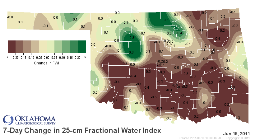
About 34% of the state is now in extreme/exceptional drought, although if you
look only at the western half, make that about 85%. It may seem like the rains
of last week should have lessened the drought severity, but unfortunately the
heat ramped up a notch once again. With the temperatures up, the moisture has
begun to disappear at a rapidly intensifying pace, as indicated on this Mesonet
map of 7-day change in soil moisture. The areas that had the more bountiful
rainfall totals improved, but they will undoubtedly be back in the brown before
too long.
http://ticker.mesonet.org/archive/20110616/latest.fwidelta.png
Mesonet stations have reached 100 degrees 26 days since May 1, including 15 out
of 16 in June. That's counting today, which is shaping up to be a doozy. Since
June 1, statewide average high temperatures are 8.7 degrees above normal. Lows
are coming in 5.6 degrees above normal. The high temperature at Tipton in
southwestern Oklahoma averaged out at 101 degrees over that time.
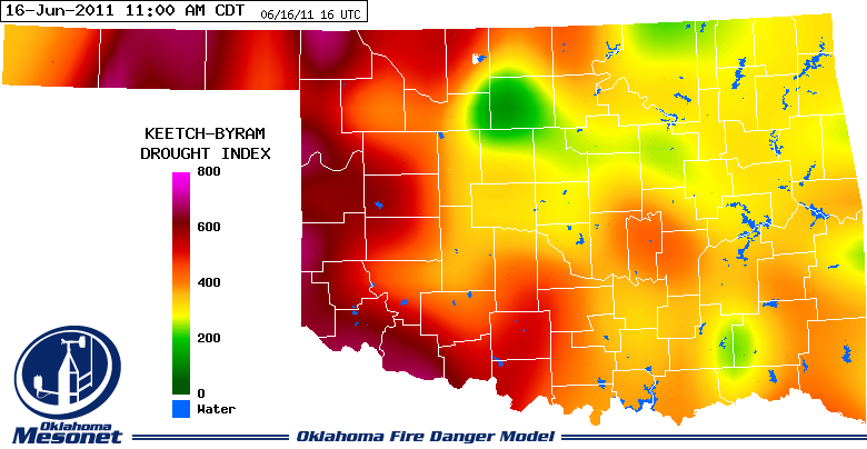
Other indicators make it fairly clear where the dry conditions are most severe,
such as this Keetch-Byram Drought Index map from the Mesonet's OK-FIRE website.
The higher numbers indicate the most severe drought conditions.
http://ticker.mesonet.org/archive/20110616/latest.kd.gif
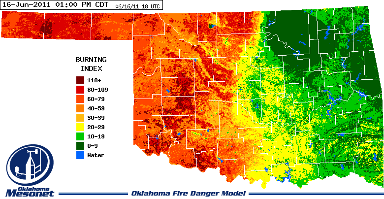
The drought has also prolonged the fire season in western Oklahoma due to the
lack of green-up, which can drastically reduce wildfire danger (tough to burn
green stuff!). Here is the latest fire-danger map from OK-FIRE (the orange-to-
red areas are the bad stuff).
http://ticker.mesonet.org/archive/20110616/latest.bi.gif
The statistics are not much better. Looking at the last 180 days or so, the
Panhandle, west central and southwestern climate divisions (basically the
western third-to-half of the state) have experienced their driest such periods
since 1921.
Last 180 Days: Dec 18, 2010 through Jun 15, 2011
Division Total Rain Dep. from Normal Pct of Normal Rank
Panhandle 2.49" -7.30" 25% 1st driest
N. Central 6.85" -8.21" 45% 4th driest
Northeast 17.43" -2.61" 87% 32nd driest
W. Central 3.95" -10.42" 27% 1st driest
Central 10.51" -8.31" 56% 7th driest
E. Central 22.00" -0.65" 97% 34th wettest
Southwest 5.61" -9.39" 37% 1st driest
S. Central 12.05" -8.43" 59% 6th driest
Southeast 23.21" -2.26" 91% 37th driest
Statewide 11.48" -6.45" 64% 6th driest
So statewide it is the 6th driest such period (Dec 18-Jun 15) since 1921, and
that ranking is obviously built on the back of western Oklahoma where a 6th
driest ranking would be a welcome change.
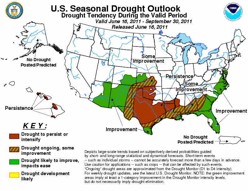
The hits keep coming. The seasonal drought outlook from the NWS' Climate
Prediction Center indicates chances the drought will persist or intensify
across western Oklahoma through the end of September. Some improvement is
forecast in the Panhandle, mainly due to their ties to the Southwest monsoon
that peaks over the summer.
http://ticker.mesonet.org/archive/20110616/season_drought.gif
Here is the CPC's reasoning:
"... a dry climatology and above-median temperatures expected during the
summer months across the southern Plains limits opportunities for
drought reduction."
Translation? It's hot and dry during the summer in Oklahoma. 'nuff said. The
July outlooks reflect that with increased chances of above normal temperatures
and below normal precipitation.
Temperature: http://ticker.mesonet.org/archive/20110616/off14_temp.gif
Rainfall: http://ticker.mesonet.org/archive/20110616/off14_prcp.gif
There is hope. Always. The outlooks during summer struggle to verify.When a
particular weather pattern sets up, it tends to persist. So if we could
shift into a rainy pattern, there is always the chance it could stay that way
(think summer 2007). That's very hard to predict. Remember, however, there is a
reason we all think of Oklahoma's summers as hot and dry. Because we've lived
a bunch of them! It would be an anomaly if they didn't turn out that way.
Gary McManus
Associate State Climatologist
Oklahoma Climatological Survey
(405) 325-2253
gmcmanus@mesonet.org
==================================================
The OCS/Mesonet Ticker
https://ticker.mesonet.org/
To subscribe or unsubscribe from the Ticker
or for questions about the Ticker or its content
Phone or Email the Ticker Manager at OCS
Phone: 405-325-2253 Email: ticker@mesonet.org
---------------------------------------------------
-C- Copyright 2024 Oklahoma Climatological Survey
===================================================
|


 Tweet
Tweet