MESONET TICKER ... MESONET TICKER ... MESONET TICKER ... MESONET TICKER ...
May 16, 2024 May 16, 2024 May 16, 2024 May 16, 2024
Faber
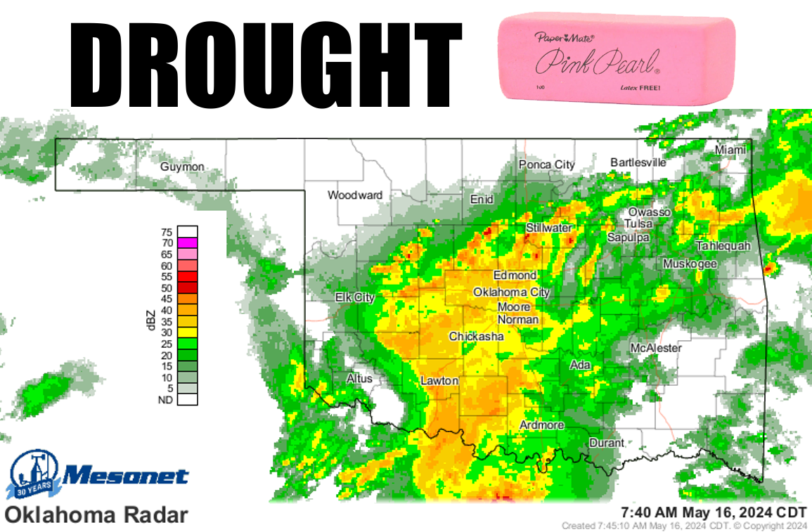
https://ticker.mesonet.org/archive/20240516/current-radar.png
See, nice gentle rains do a body good. What DOESN'T do a body good is the
softball size hail that fell across northern Oklahoma yesterday that'll put knots
on your noggin' faster'n you can rub 'em (I originally typed "rum 'em"...that might
help too).
https://ticker.mesonet.org/archive/20240516/yesterday.png
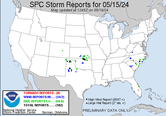
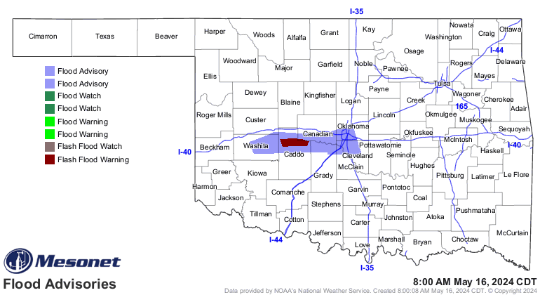
Or the severe winds that knocked power out to thousands. Or the non-gentle rains
that have produced flash flooding.
https://ticker.mesonet.org/archive/20240516/latest.oklahoma.flood.gif
Wait, I'M in that advisory area! Doesn't Mother Nature know who I am? Well, at any
rate, certainly better than what some Mays have to offer, but if we're looking
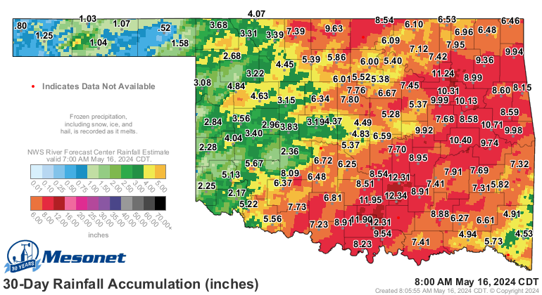
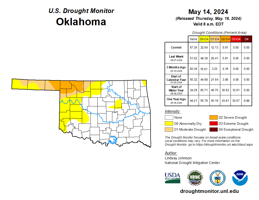
for silver linings, the rains we've seen have reduced drought considerably from
its peak just a few weeks ago when flash drought was running rampant through
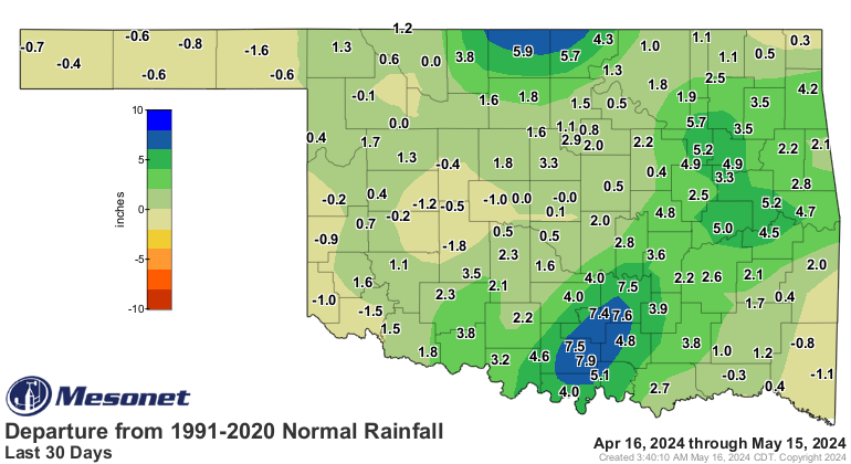
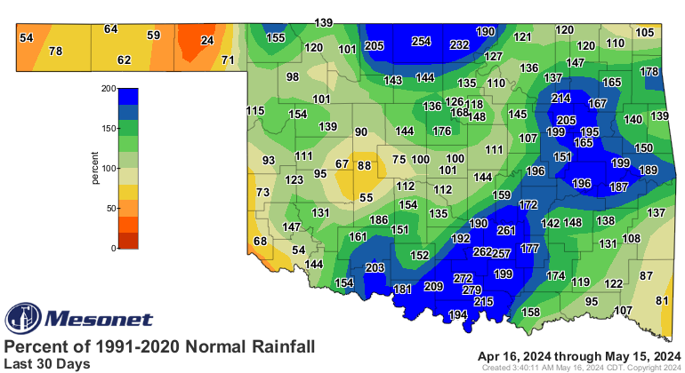
the state. Check out the 30-day rain amounts, for instance.
https://ticker.mesonet.org/archive/20240516/30day-rain-totals.png
https://ticker.mesonet.org/archive/20240516/del30day_rain.current.png
https://ticker.mesonet.org/archive/20240516/pct30day_rain.current.png
ZOUNDS but that's a lot of rain, even for April/May in Oklahoma! Still have
deficits in the Panhandle and other areas of western Oklahoma, but we've
dramatically reduced the problem areas in the state.
https://ticker.mesonet.org/archive/20240516/20240514_ok_trd.png
Trust me, I know problem areas (insert bald joke here).
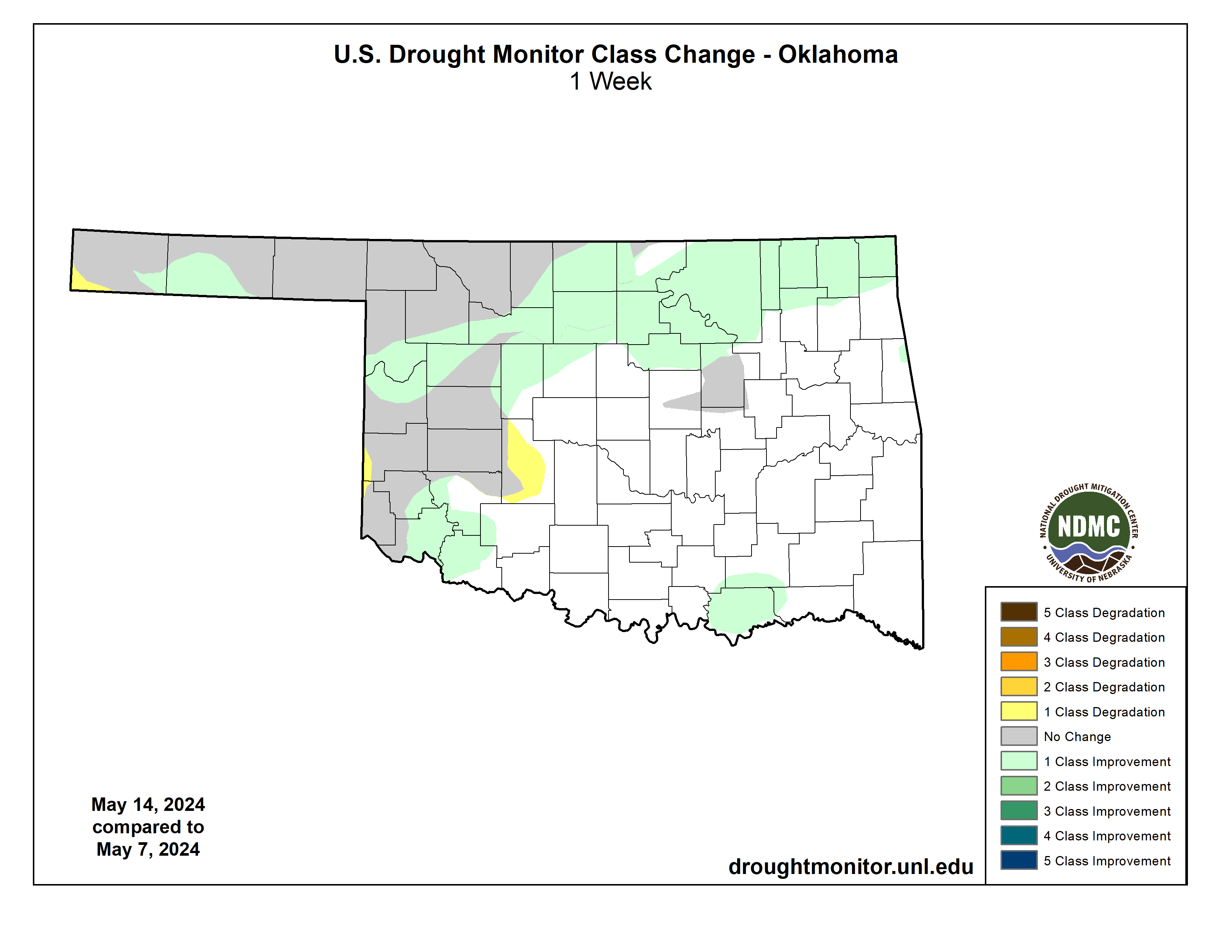
Remember, only rains that fall between Tuesday 7am-Tuesday 7am can be considered
for a week's Drought Monitor, so the rains that fell AFTER 7am on Tuesday, May
14, will impact next week's Drought Monitor. This week saw a bit of movement
regardless.
https://ticker.mesonet.org/archive/20240516/1week-change.png
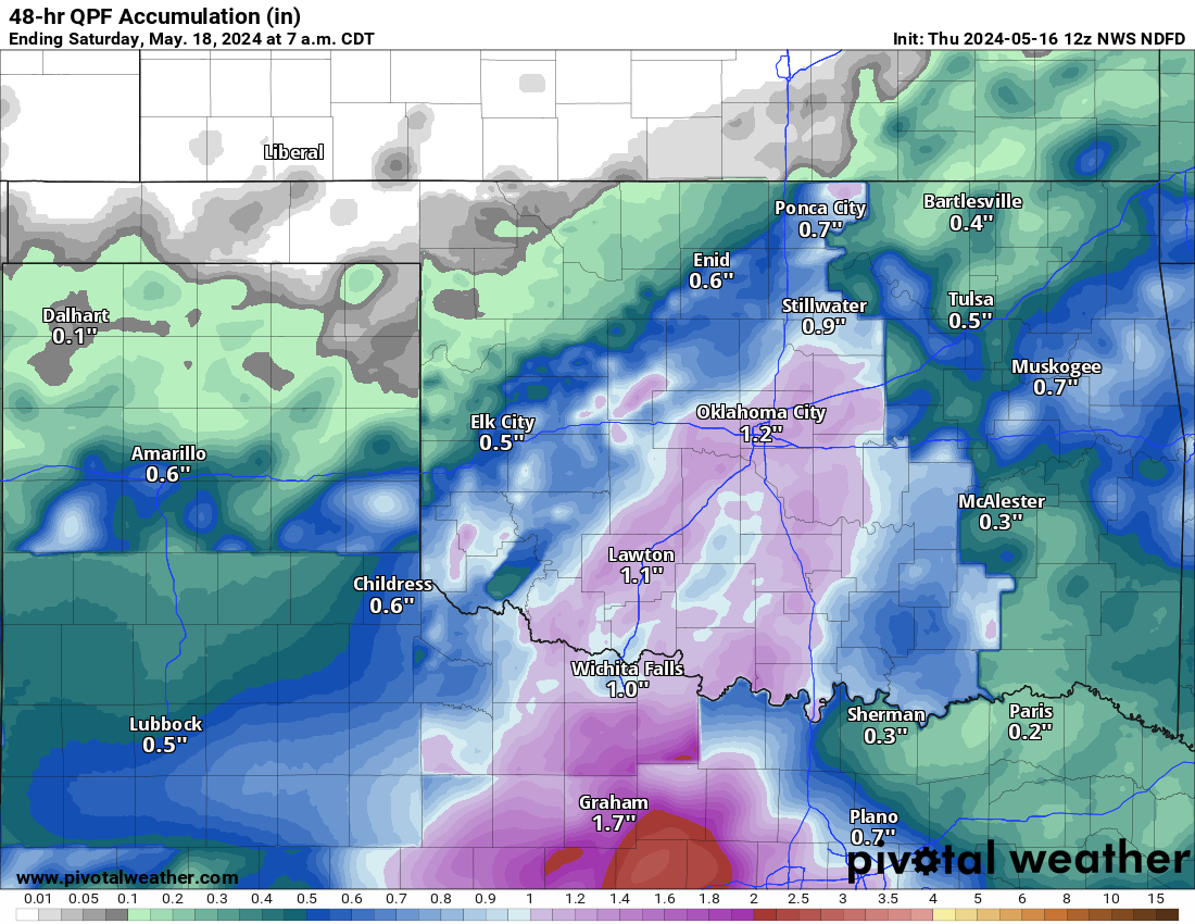
And rains that have yet to fall.
https://ticker.mesonet.org/archive/20240516/48hour-rain-forecast.png
What can I say...no, seriously, what can I say? Oh, yeah, things get a lot more
quiet after this. We may see some chances for storms next week, but a strong
cap will be in place so one of those conditional things.
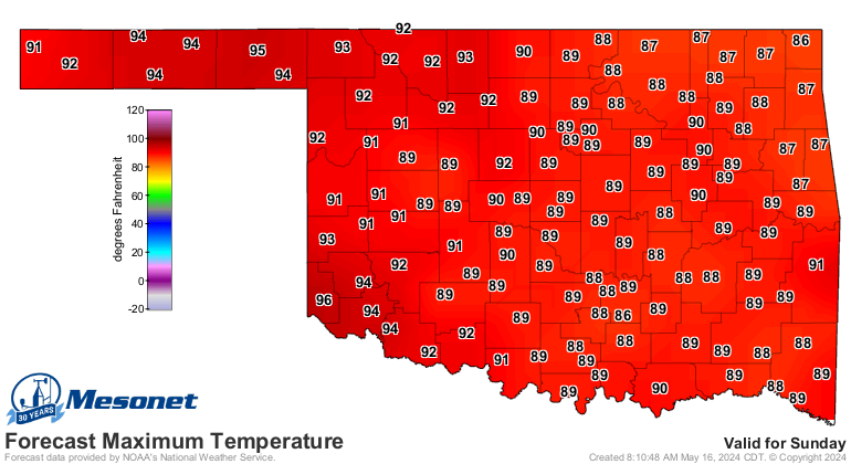
WAIT! Don't go yet. I have more good (bad) news! Who's ready for summer early
next week?
https://ticker.mesonet.org/archive/20240516/sunday-highs.png
https://ticker.mesonet.org/archive/20240516/monday-highs.png
Yayyyy, summer heat! Summer heat after all this rain we've had?
BOO! Summer heat indexes! Get ready...it's coming.
Gary McManus
State Climatologist
Oklahoma Mesonet
Oklahoma Climatological Survey
gmcmanus@mesonet.org
==================================================
The OCS/Mesonet Ticker
https://ticker.mesonet.org/
To subscribe or unsubscribe from the Ticker
or for questions about the Ticker or its content
Phone or Email the Ticker Manager at OCS
Phone: 405-325-2253 Email: ticker@mesonet.org
---------------------------------------------------
-C- Copyright 2024 Oklahoma Climatological Survey
===================================================
|


 Tweet
Tweet