MESONET TICKER ... MESONET TICKER ... MESONET TICKER ... MESONET TICKER ...
October 15, 2018 October 15, 2018 October 15, 2018 October 15, 2018
Dectober?
http://ticker.mesonet.org/archive/20181015/Octcember.png
Well, you got your wish! It's cold again...now what do you have to say for
yourself??
(insert glare here)
Okay okay, we'll concede it was time for a change. Why not go from summer to a
brief view of fall, then right on to winter. That's about right for Oklahoma,
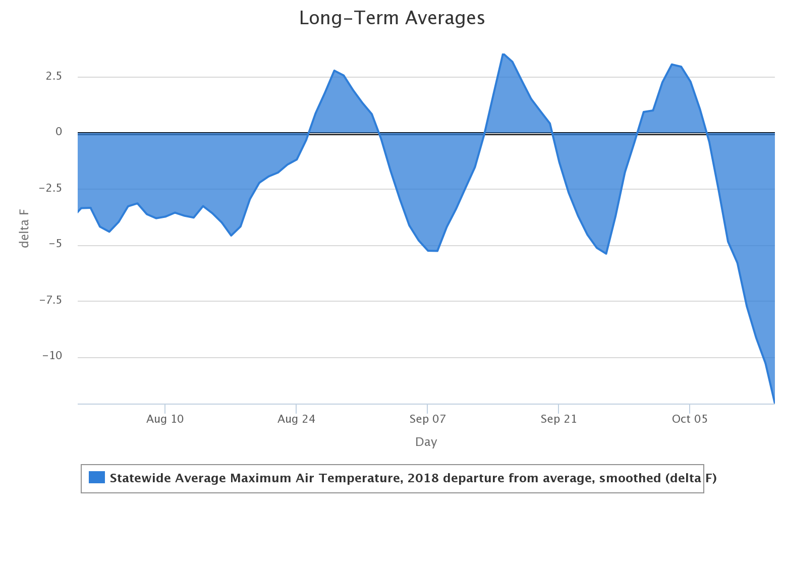
ain't it? For proof that Mother Nature just can't make up here mind, check out
this graph of the departure from average statewide-average maximum air temps, as
calculated from the Oklahoma Mesonet, since August 1. The long-term average here
is 2003-2017. You can see our cold August, then the summer/fall roller coaster,
then right to winter over the last couple of days.
http://ticker.mesonet.org/archive/20181015/Aug1-Oct14-depart-avg-highs.png
Quite the change, especially considering it was just a week ago we were dealing
with highs in the 80s and 90s, with oppressive heat index values to boot. But as
we look to our latest cold air outbreak, we see the first freezing weather
recorded by the Mesonet since April 27 when we saw a slew of 31s and 32s in
the Panhandle. Yesterday saw some 20s, and then that expanded today.
http://ticker.mesonet.org/archive/20181015/yesterdays-lows.png
http://ticker.mesonet.org/archive/20181015/todays-lows.png
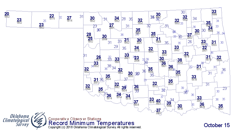
In some cases, today's lows were near record-breaking values, if not new records
outright.
http://ticker.mesonet.org/archive/20181015/Oct15-record-lows.png
Throw the wind in there and it was just plain cold all over.
http://ticker.mesonet.org/archive/20181015/todays-low-windchills.png
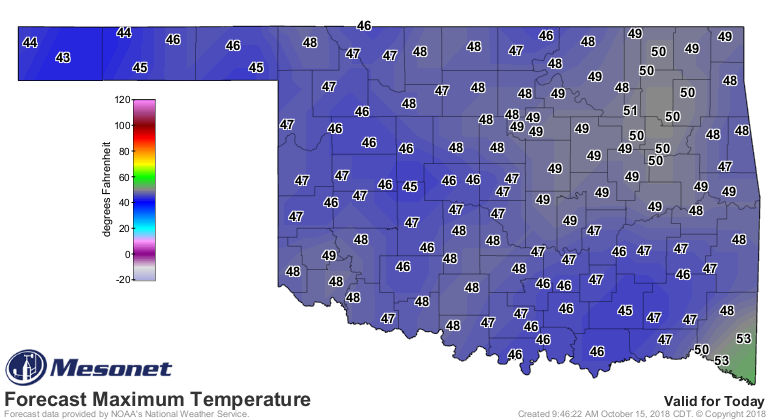
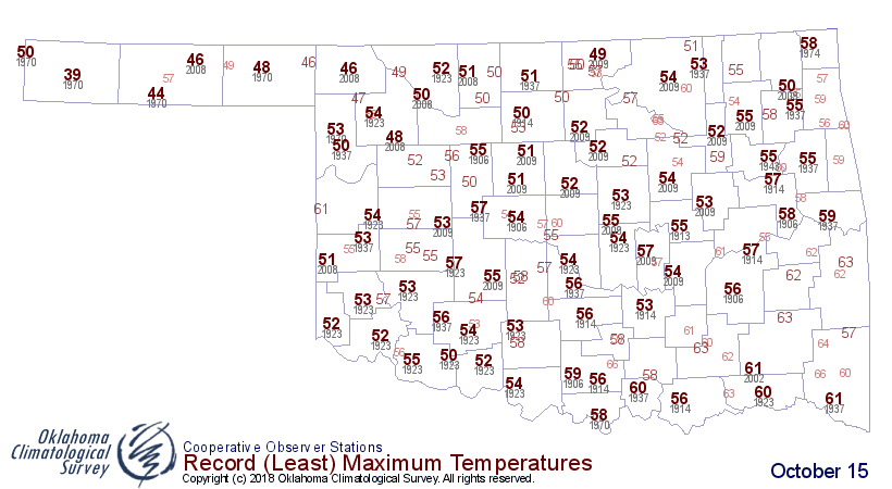
AND, things don't get too much better this afternoon, where our maximum temps
are expected to be in record-shattering territory for much of the state.
http://ticker.mesonet.org/archive/20181015/forecast-highs-today.png
http://ticker.mesonet.org/archive/20181015/Oct15-record-low-tmax.png
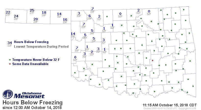
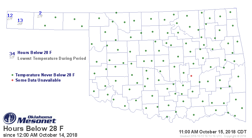
For those worried about crops or plants, there is some concern there as much
of northwestern Oklahoma spent at least a few hours below the freezing mark
the last couple of days, and the far western Panhandle has spent a significant
amount of time below 28.
http://ticker.mesonet.org/archive/20181015/hours-below-32.png
http://ticker.mesonet.org/archive/20181015/hours-below-28.png
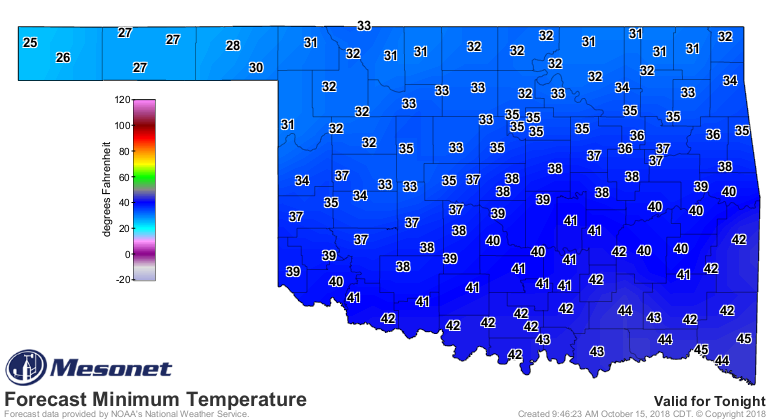
Add some more onto that tomorrow morning as well.
http://ticker.mesonet.org/archive/20181015/tuesday-morning-lows.png
But for the rest of us (no, NO FESTIVUS!!), what does it really matter? Throw
on a coat, fire up the, uh...fire, and go shopping for Halloween candy. The
stores already have the Christmas stuff out anyway. Might as feel that way
outside, too.
Gary McManus
State Climatologist
Oklahoma Mesonet
Oklahoma Climatological Survey
(405) 325-2253
gmcmanus@mesonet.org
==================================================
The OCS/Mesonet Ticker
https://ticker.mesonet.org/
To subscribe or unsubscribe from the Ticker
or for questions about the Ticker or its content
Phone or Email the Ticker Manager at OCS
Phone: 405-325-2253 Email: ticker@mesonet.org
---------------------------------------------------
-C- Copyright 2024 Oklahoma Climatological Survey
===================================================
|


 Tweet
Tweet