Ticker for August 15, 2012
MESONET TICKER ... MESONET TICKER ... MESONET TICKER ... MESONET TICKER ...
August 15, 2012 August 15, 2012 August 15, 2012 August 15, 2012
Latest druoth map (or is it?)
Happy August 15th day, otherwise known as the day after August 14th. Here's the
latest drouth map, which came out on Aug. 10th. It shows crops being very poor
across Oklahoma.
https://content.mesonet.org/ticker/archive/20120815/aug10-drought-map.pdf
Pulled a fast one there, didn't I! And fast for a climatologist is glacially
slow, so the bar is set fairly low. As a colleague remarked, that map from 1934
is eerily similar to the present-day situation. I'll just go out on a limb here
and say for most Okies, I hope that's where the parallels to the 1930s end!
Otherwise, 2019 is a long time to await the end of our current drought (Dust
Bowl drought in Oklahoma ended in 1941).
Here is a summary of the weather for the week of Aug. 15-21- 1934. Again, eerily
simlar!
?As the week progressed, temperatures moderated in all sections of the
country, except in the Southwest, and by [the close of the week]
abnormally cool weather prevailed in much of the Midwest where
temperatures have been extremely high for a long time ... The reaction
to the cooler weather was pronounced? Over much of the interior it was
the first week with below-normal temperatures since last spring.?
Now here's a parallel to hope for, from late August, 1934:
?Recent rains have brought decided improvement to conditions in the Ohio
Valley, Missouri, much of Arkansas, Oklahoma, western Texas, New Mexico,
and much of Arizona? Moisture of the past week in the southwestern
area was especially helpful in reviving fall pastures, supplying stock
water, and permitting the planting of?small grains for fall pastures."
Back to the present, for some of you this is an especially happy morning with
a bit of rain in the old coffee can. Fairly insignificant for most, but down
in south central Oklahoma, the rain was a nice soaker of up to 1.5 inches.
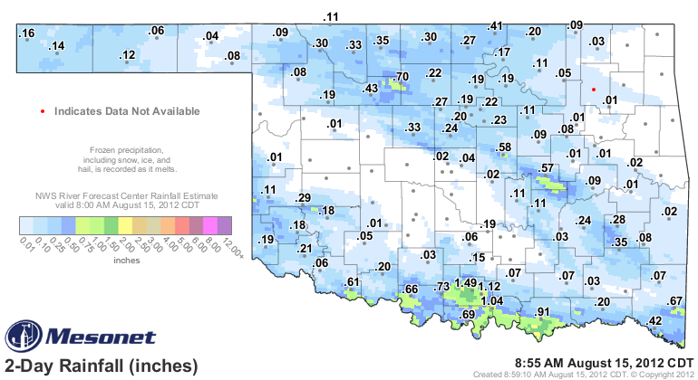
The areas around Lahoma and Okemah also saw around an inch, but again that rain
was pretty localized.
For my house: zero-point-zero.
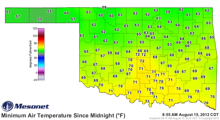
The area in blue also saw a bit of a cool down, and dropped into the low-to-mid
60s this morning.
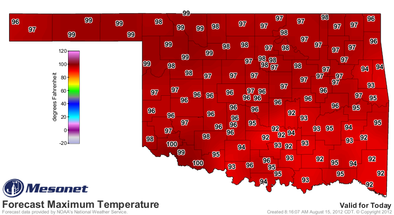
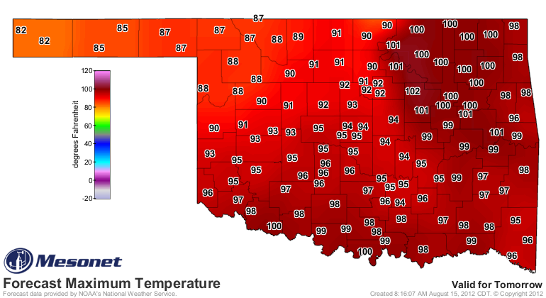
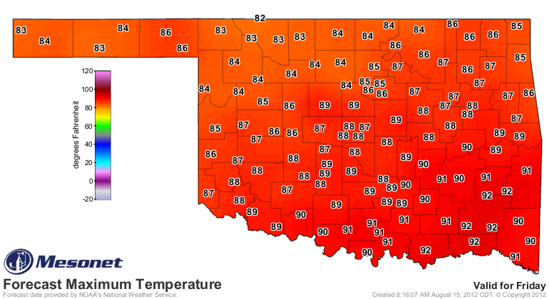
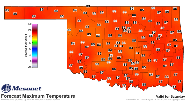
Two more hot days for most, the NWS' forecast gets much more pleasant on Friday
and Saturday.
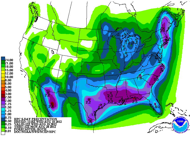
The HPC has the heaviest rain down to the southeast, but I think with that front
hanging around Thursday night, we can see some heftier totals farther to the
northwest (DISCLAIMER: a weather forecast by a climate guy).
A bit farther out, the CPC's 6-10 and 8-14 day outlooks continue to indicate
elevated chances of cooler and drier than normal weather in store for our neck
of the woods. We'll welcome the cooler chances and hope for better odds with
the moisture.
http://www.cpc.ncep.noaa.gov/products/predictions/610day/index.php
http://www.cpc.ncep.noaa.gov/products/predictions/814day/index.php
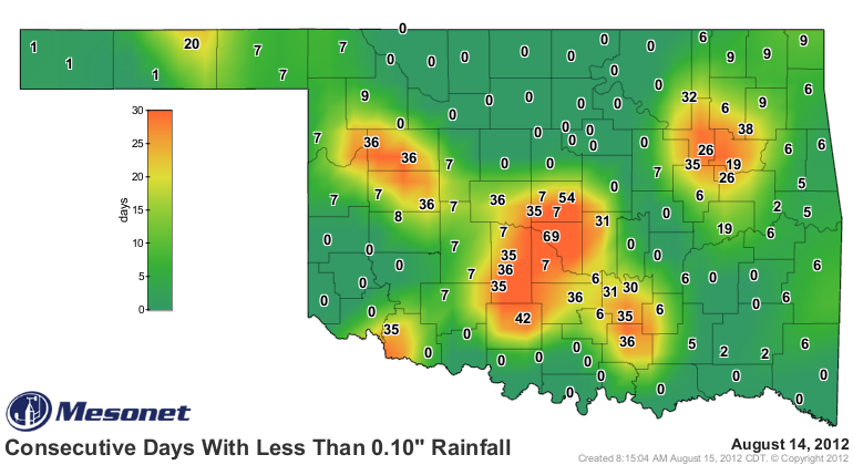
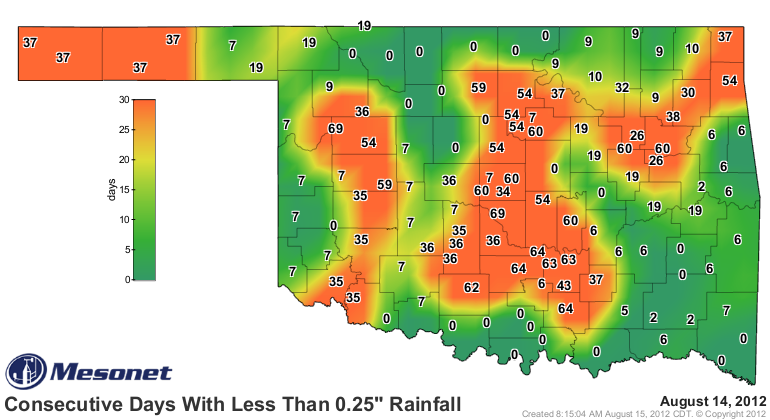
Our map of locations with less than a tenth of an inch of rainfall in any
single day has shrunk considerably, with Norman still serving as the epicenter
at 69 days.
The same map but for 0.25 inches of rain is still a bit too orange.
Drought, drought, whatever name it goes by ... time to go away!
Gary McManus
Associate State Climatologist
Oklahoma Climatological Survey
(405) 325-2253
gmcmanus@mesonet.org
August 15 in Mesonet History
| Record | Value | Station | Year |
|---|---|---|---|
| Maximum Temperature | 107°F | GRA2 | 2024 |
| Minimum Temperature | 50°F | EVAX | 2016 |
| Maximum Rainfall | 4.96″ | WIST | 2018 |
Mesonet records begin in 1994.
Search by Date
If you're a bit off, don't worry, because just like horseshoes, “almost” counts on the Ticker website!