MESONET TICKER ... MESONET TICKER ... MESONET TICKER ... MESONET TICKER ...
May 15, 2024 May 15, 2024 May 15, 2024 May 15, 2024
You want a piece of me?
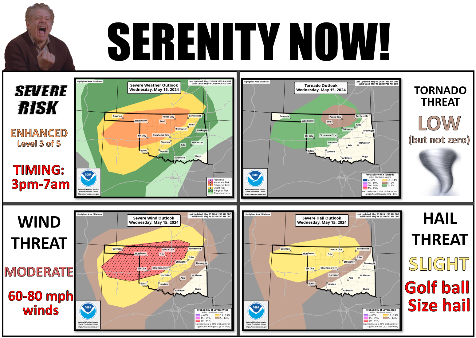
https://ticker.mesonet.org/archive/20240515/severe-threat.png
AHA! See, I told you that the "Marginal" risk for today might be upgraded. Now I
did say to "Slight," but the folks at SPC wanted me to look bad so they gave me
a mirror.
No wait! That didn't work out as well as I expected. That's what my SCALP said!
Rats, sorry, I left the self-deprecating mode clicked on the Ticker. Let's try
this again. So we went from Marginal yesterday (for today) to a Moderate risk of
severe weather, or level 3 of 5 (hey, "3 of 5" was my band's name at the Star
Trek Convention!). Something of a complicated setup for today, with several areas
of storm development possible. The biggest risk of supercells will be across
northern Oklahoma near the triple-point of the dryline, cold front, and warm
front. Once those get going, we'll have to see what they do later on with throwing
outflow boundaries that help initiate more storms. The biggest threat with these
storms appears to be severe winds, but tornadoes can't be ruled out.
Trust me, if I could I'd go ahead and rule away!
There will also be the threat of flash flooding. Much of northern Oklahoma is
already quite moist, so heavy rains up that way could cause problems.
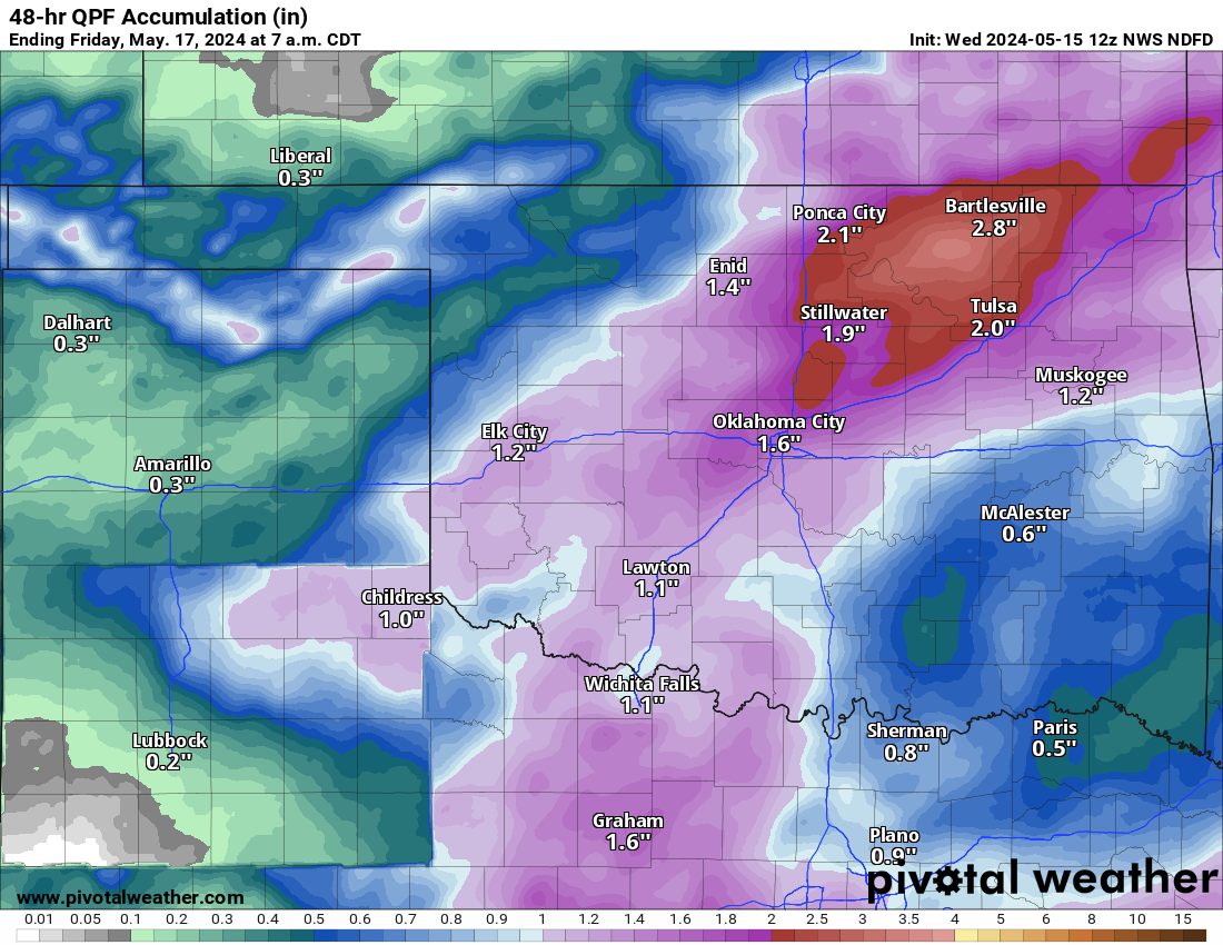
https://ticker.mesonet.org/archive/20240515/48hour-forecst.png
This rain should fall through the next 36 hours or so and lead us into a pretty
nice weekend. Hopefully not much storm cleanup needed on those days from the
storms later today.
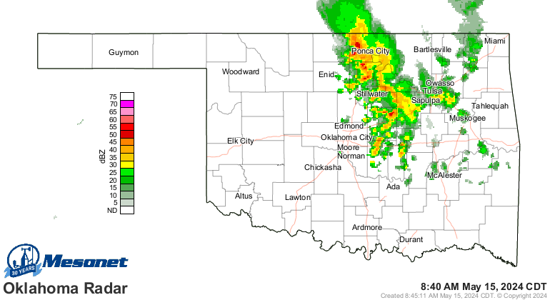
Later today? Heck, it's storming right now for crying out loud!
https://ticker.mesonet.org/archive/20240515/current-radar.png
By the way, that's labeled "current radar" but it's actually happening then to
you, not now. See, it's now now, but it'll be then later, or before.
Everybody got that?
Gary McManus
State Climatologist
Oklahoma Mesonet
Oklahoma Climatological Survey
gmcmanus@mesonet.org
==================================================
The OCS/Mesonet Ticker
https://ticker.mesonet.org/
To subscribe or unsubscribe from the Ticker
or for questions about the Ticker or its content
Phone or Email the Ticker Manager at OCS
Phone: 405-325-2253 Email: ticker@mesonet.org
---------------------------------------------------
-C- Copyright 2024 Oklahoma Climatological Survey
===================================================
|


 Tweet
Tweet