Ticker for September 13, 2023
MESONET TICKER ... MESONET TICKER ... MESONET TICKER ... MESONET TICKER ...
September 13, 2023 September 13, 2023 September 13, 2023 September 13, 2023
Not bad?
First off, I was told there would be no math. Then, after 6 years and 2 degrees
(BRRR!!! No, wait...college degrees) later, I knew I had been hornswoggled (and
we all know just how painful that can be). But when I saw the newest rainfall
forecast through the weekend, I thought we had ALL beeh hornswoggled. I mean,
didn't we see much more rain being forecast (WOE BE TO THOSE THAT USE THE
INCORRECT WORD "FORECASTED") before our weather pattern change? Here we get a look
from last Friday.
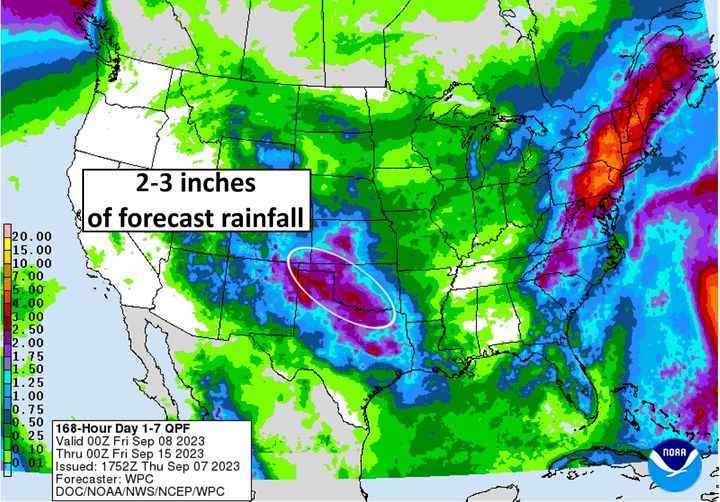
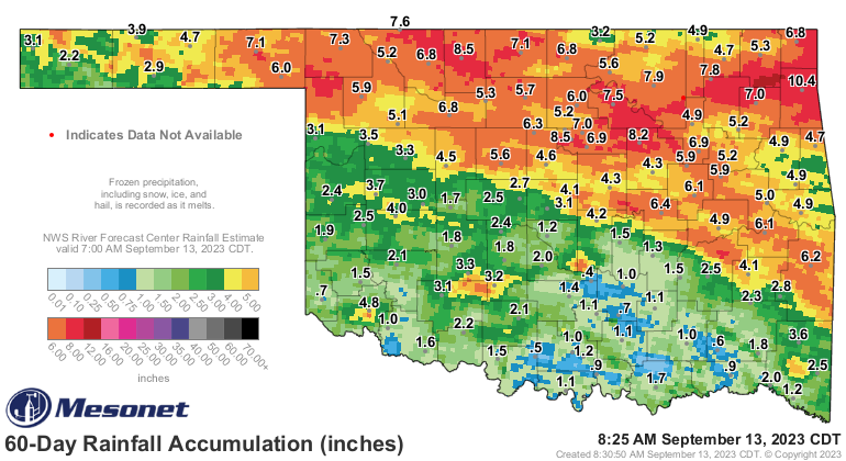
Hmm, it might have pushed to the SW a little bit, but I guess that's going to
be pretty close. In fact, some areas have already received what was forecast and
then some.
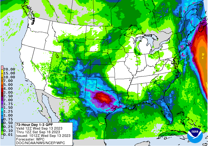
Still, a lot's riding on the rain expected over the next 3 days, because some
folks need a lot more. We have managed to reset those nasty looking consecutive
days maps from the Mesonet, but reaching at least a quarter-inch of rain is
nice, but not nearly enough. And some folks trudge on with the count continuing
upwards.
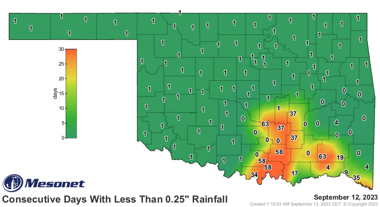
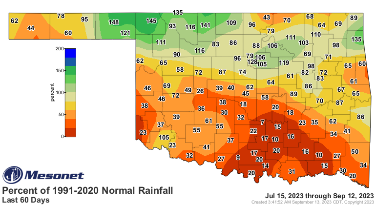
Here's the "not nearly enough" part...and no, I'm not gonna make a bald joke
here and talk about my hair. Looking at the last 60 days, we continue to see
much of the SW half of the state continuing in dire flash drought mode.

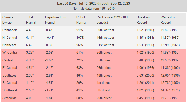
Heck, the last 60 days have been the driest such period for south central
Oklahoma in at least the last 100 years, and that's been the case for the last
several days as well.
So the answer to the math question at the top of the page: NOT ENOUGH!
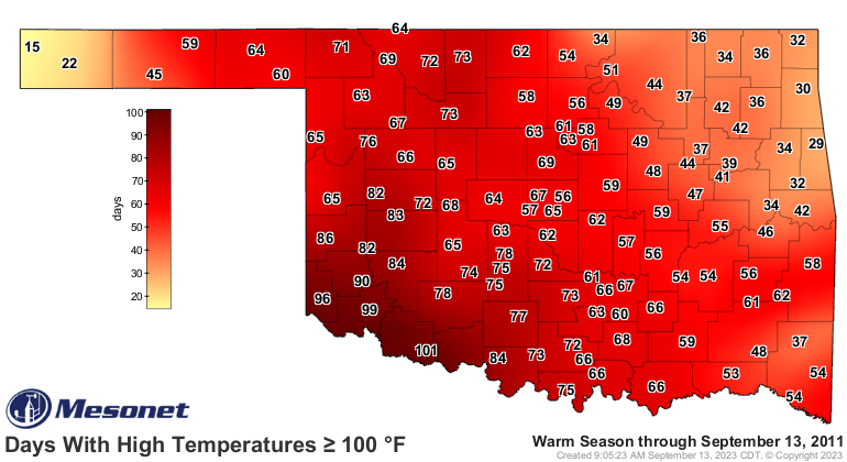
Hey, before we go, did you know that this day back in 2011 was "The Day the
100s Died?"
There were a few triple-digit readings after that, but by and large, this was
the last "really hot" day that ended the worst heat wave in OK history. With
severe drought in place entering June, extreme summer heat was sure to follow.
Simply put, Oklahoma experienced the hottest summer of any state since records
began in 1895 with a statewide average of 86.8 degrees. July's average
temperature was 89.2 degrees, becoming the hottest month for any state on
record, besting over 67,000 other months. The state also experienced its second
hottest June and hottest August on record. The Oklahoma Mesonet site at
Grandfield recorded 101 days above 100 degrees, breaking the previous state
record of 86 days from Hollis in 1956. Oklahoma City's 63 100-degree days
shattered its previous mark of 50 from 1980. Similar records were broken
throughout western Oklahoma.
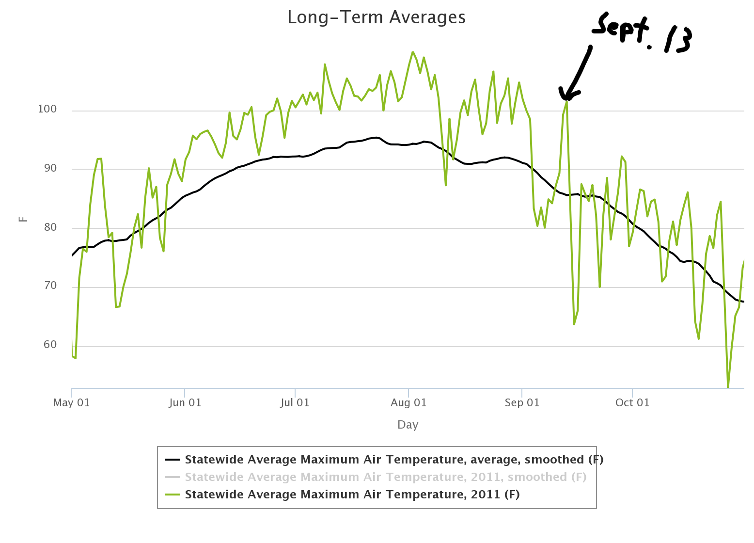
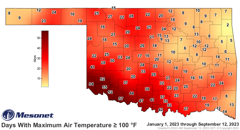
Makes this summer's 1.5 month-long heat wave pretty puny in comparison. Sorta
like comparing my hair to Sean Penn's. DOH! I thought we weren't going there!
Gary McManus
State Climatologist
Oklahoma Mesonet
Oklahoma Climatological Survey
gmcmanus@mesonet.org
September 13 in Mesonet History
| Record | Value | Station | Year |
|---|---|---|---|
| Maximum Temperature | 109°F | WALT | 2011 |
| Minimum Temperature | 40°F | NEWK | 2014 |
| Maximum Rainfall | 5.53 inches | TULL | 1998 |
Mesonet records begin in 1994.
Search by Date
If you're a bit off, don't worry, because just like horseshoes, “almost” counts on the Ticker website!