MESONET TICKER ... MESONET TICKER ... MESONET TICKER ... MESONET TICKER ...
December 12, 2016 December 12, 2016 December 12, 2016 December 12, 2016
The Arctic is open for bidness
Had enough? I know I know, most of you won't throw up the white flag and yearn
for spring until we've had a good snow. HAHA!!
Good snow.
Jumbo shrimp.
Open secret.
Controlled chaos.
Yes, I'm the king of oxymorons, whith emphasis on "moron." We've now suffered
through a couple of weeks of winter after a non-existent autumn, and now I'm ready
to go see that autumn! The Tulsa NWS office gives us a great display of what we're
in store for this week (and the same sort of scenario that we've seen over the
last 2 weeks) with this graphic:
http://ticker.mesonet.org/archive/20161212/nws-tulsa-arctic-setup.gif
There will be a cold front tomorrow, Wednesday and then again sometime this
weekend that could have a bit of wintry weather with it (that forecast with flesh
out a bit better as we get closer...but it doesn't look like a major storm
system at this time).
As noted about this coming weekend when a lot of you will no doubt be cramming
the malls and stores for a bit of shopping:
"Clearly there remains a good deal of uncertainty in how all of
this will evolve and it is worth noting that precip type
forecasting many days in advance is an inexact science. The
important thing to take from this is that we should be prepared
for a strong cold front this weekend and there is at least some
potential for winter weather with this front. No matter which
model you believe, a more direct punch of arctic air will filter
into our area in the wake of the ejecting large scale trough. The
latter part of the weekend and early next week will probably feel
like we've been inserted into an ice box."
Hey, the weather is nothing to joke about! Oh, wait. Well, to translate their
translation, it's going to be cold, colder, colder still, then get warmer, then
get REALLY cold. I mean, does this wind chill forecast for Sunday morning look
cold to you?
http://ticker.mesonet.org/archive/20161212/sunday-morning-windchill.forecast.png
I would expect highs next Sunday and Monday at the least could have trouble
getting out of the 20s.
On the warm side, Newport and Burneyville had the month's highest temperature
thus far at 73 degrees yesterday.
http://ticker.mesonet.org/archive/20161212/yesterdays-highs.png
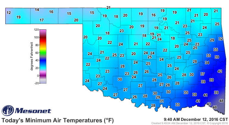
Unfortunately, all that autumnal good will was long gone this morning.
http://ticker.mesonet.org/archive/20161212/todays-lows.png
The consecutive days with lows below 32 degrees is 14 and growing in the
Panhandle, down to 6-8 days in the NW. We might wipe this map clean come Friday
only to see a new streak start on Saturday.
http://ticker.mesonet.org/archive/20161212/tmin.le32_streak.png
The other streak we're worried about might continue until March. Let's hope not.
http://ticker.mesonet.org/archive/20161212/mesonet.rainfall.quarterinch.png
http://ticker.mesonet.org/archive/20161212/7day-precip-forecast.gif
Gary McManus
State Climatologist
Oklahoma Mesonet
Oklahoma Climatological Survey
(405) 325-2253
gmcmanus@mesonet.org
==================================================
The OCS/Mesonet Ticker
https://ticker.mesonet.org/
To subscribe or unsubscribe from the Ticker
or for questions about the Ticker or its content
Phone or Email the Ticker Manager at OCS
Phone: 405-325-2253 Email: ticker@mesonet.org
---------------------------------------------------
-C- Copyright 2024 Oklahoma Climatological Survey
===================================================
|


 Tweet
Tweet