MESONET TICKER ... MESONET TICKER ... MESONET TICKER ... MESONET TICKER ...
October 11, 2022 October 11, 2022 October 11, 2022 October 11, 2022
Groovy!
https://ticker.mesonet.org/archive/20221011/unicorn.png
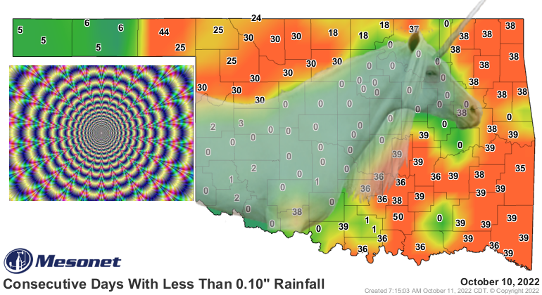
First off, TELL ME YOU SEE THE UNICORN IN OUR DAYS WITHOUT AT LEAST A TENTH OF AN
INCH IN A SINGLE DAY MAP! You see that too, man? Because the Ticker is illicit
substance free! Well, other than a strong dose of cherry Pop-Tarts (strawberry??
AS IF!) and skim milk. Nah, I don't touch the hard stuff...2% milk is about as
crazy as I'll get.
But that map doesn't really tell us much, other than Mother Nature has been
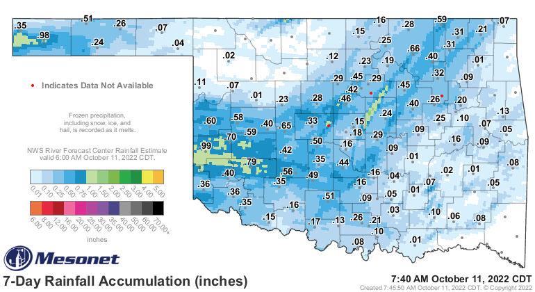
getting into her own mushroom supply. If we take a look back at the last 7 days,
and that's not a coincidence because that's the rainfall we're allowed to
consider for the this week's Drought Monitor map, we can see that lots of folks
received some beneficial rainfall, but almost no one got a dose of drought-relief.
More like drought-delaying relief at the most.
https://ticker.mesonet.org/archive/20221011/7day-rain-totals.png
Now we're not complaining, mind you, and I won't mind you if you don't mind me,
but as the so-called "local drought expert" for the state for interaction with
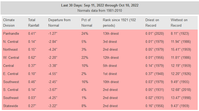
the U.S. Drought Monitor, I can simply say we need a whole lot more. Even for
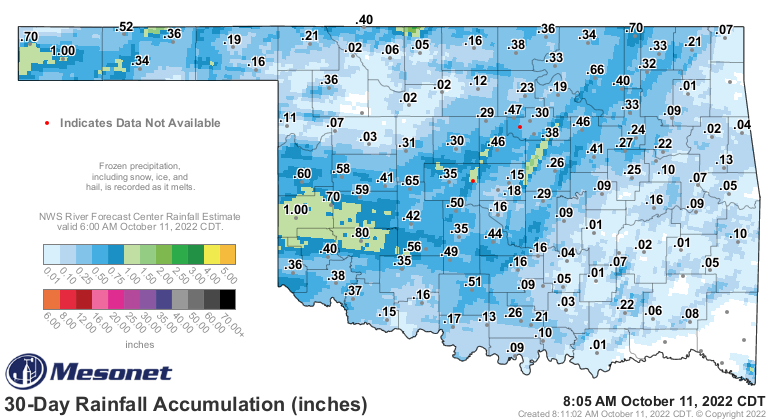
the last 30 days, that was still just a blip in our secondary rainy season
where we should be seeing a statewide average of about 3.5" or so. And that
period is still the second driest in the last 100 years
https://ticker.mesonet.org/archive/20221011/last30days-stats.png
https://ticker.mesonet.org/archive/20221011/30day-rain-totals.png
https://ticker.mesonet.org/archive/20221011/del30day_rain.current.png
https://ticker.mesonet.org/archive/20221011/pct30day_rain.current.png
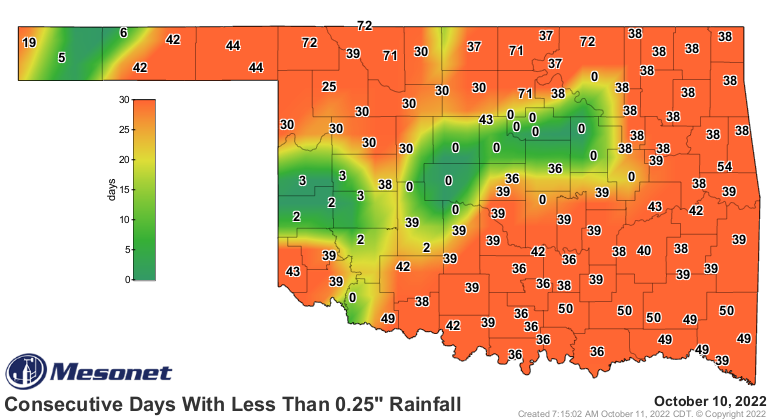
And no optical illusions on our days without a quarter-inch of rain map.
https://ticker.mesonet.org/archive/20221011/mesonet.rainfall.quarterinch.png
A few chances for rain today and tomorrow, then over the weekend, but still
not much in the way of accumulations. We'll be dealing with another of those
closed low situations (and we all know just how painful that can be) in the
Desert Southwest. At least I think it looks like a closed low in the forecast
models as it wanders around the Four Corners area like a former Grateful Dead
roadie looking for a ride to Vegas. Whenever it decides to meander over this
way, it might bring some rain to the area later on, but still not sure about
that one.
https://ticker.mesonet.org/archive/20221011/5day-rain-forecast.gif
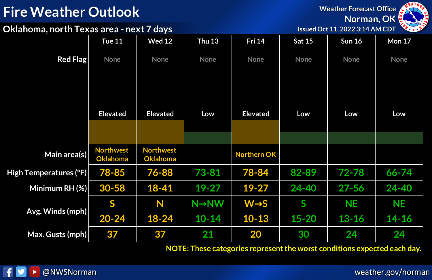
Now with the dead vegetation hanging around due to the drought and our
elongated summer weather, anytime one of these fronts moves into the area the
winds will kick up and we'll see elevated fire danger. Not into the extreme
territory just yet, but we're just getting started.
https://ticker.mesonet.org/archive/20221011/nws-norman-fire.danger.png
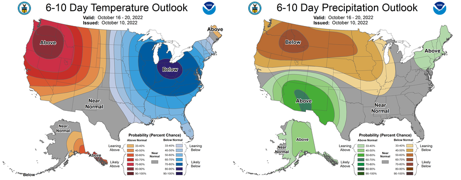
There should be some actual COLD air coming our way next week with a large
area of winter plunging into the eastern half of the U.S. bulges its way
towards us, even as that upper-low across the Desert SW allows for some rain
in our western areas.
https://ticker.mesonet.org/archive/20221011/oct16-20-outlooks.png
Far out, man, as in "we wish that cold air was far out, man, like in another
3 months or so."
Gary McManus
State Climatologist
Oklahoma Mesonet
Oklahoma Climatological Survey
gmcmanus@mesonet.org
==================================================
The OCS/Mesonet Ticker
https://ticker.mesonet.org/
To subscribe or unsubscribe from the Ticker
or for questions about the Ticker or its content
Phone or Email the Ticker Manager at OCS
Phone: 405-325-2253 Email: ticker@mesonet.org
---------------------------------------------------
-C- Copyright 2024 Oklahoma Climatological Survey
===================================================
|


 Tweet
Tweet