MESONET TICKER ... MESONET TICKER ... MESONET TICKER ... MESONET TICKER ...
September 11, 2023 September 11, 2023 September 11, 2023 September 11, 2023
And I feel fine
https://ticker.mesonet.org/archive/20230911/summers-end.png
Okay, who else is tired of this cold weather? Man, I can't wait until spring!
A little over the top? Maybe, but this is a pattern change nearly everybody
wanted, but for me there is just a bit of buyer's remorse, and I know buyer's
remorse because my wife tells me about it all the time! Maybe it's the abruptness?
I mean, through yesterday we were scooting along with a nearly two-month long heat
wave that started right around July 21.
https://ticker.mesonet.org/archive/20230911/heat-wave-end.png
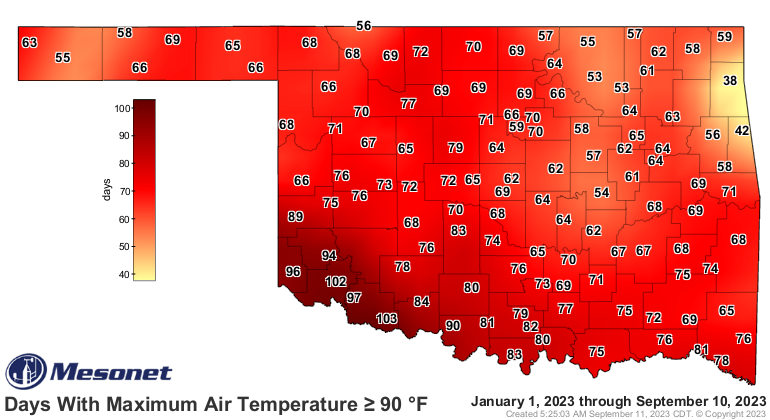
In fact, today might be the first day in 57 days that we don't see a 90-degree
temperature somewhere in the state, let along the 100s we've been seeing pretty
regular.
https://ticker.mesonet.org/archive/20230911/tmax.ge90_streak.png
And I don't think either of these maps are finished adding numbers, especially the
days with highs above 90 degrees map, but we're close to ending the 100s map. In
other words...the summer as we knew it is over.
https://ticker.mesonet.org/archive/20230911/tmax.ge90.png
https://ticker.mesonet.org/archive/20230911/tmax.ge100.png
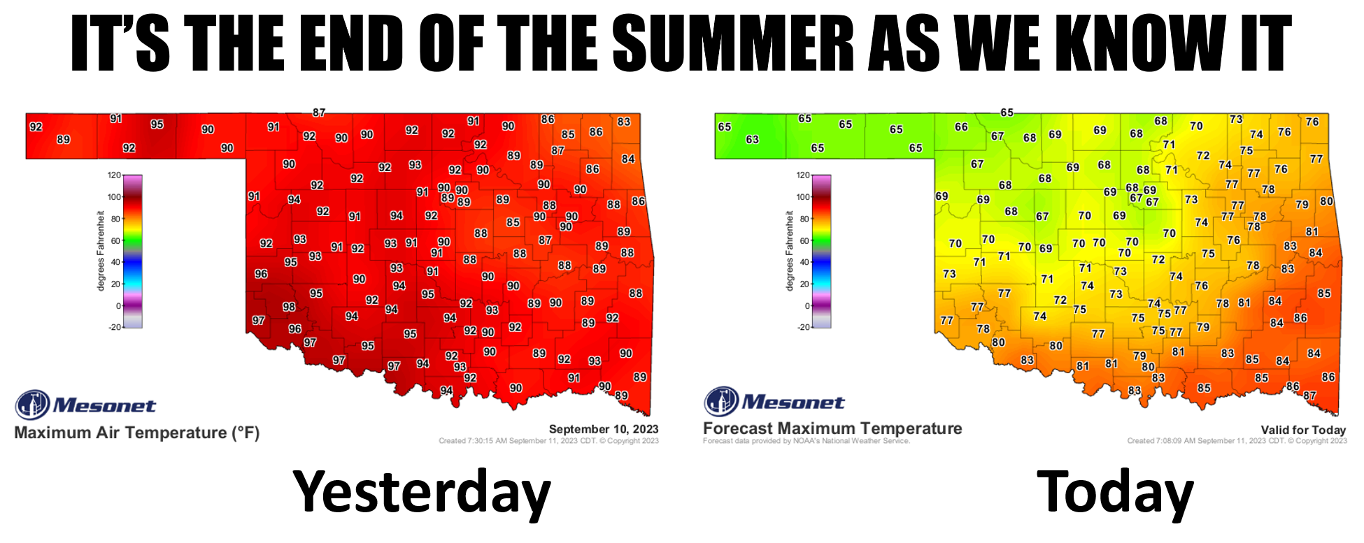
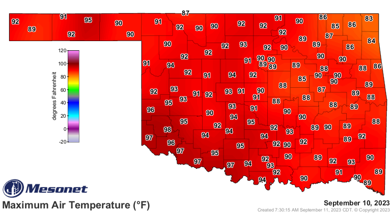
How abrupt of a change is it? Well, we're going from this yesterday
https://ticker.mesonet.org/archive/20230911/yesterdays-highs.png
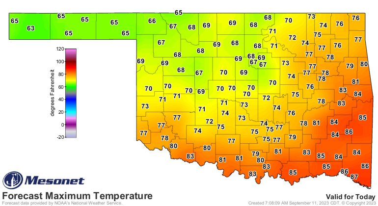
to this today.
https://ticker.mesonet.org/archive/20230911/todays-forecast-highs.png
In fact (part 2), I'll bet we see some record LOW tmaxes (tmaxeses?) up across
NW OK today where highs will struggle to get out of the 60s.
https://ticker.mesonet.org/archive/20230911/sept11-low-tmax-records.png
In fact (STOP ME BEFORE I IN FACT AGAIN!!), NW OK could see highs in the 60s
the rest of this work week!
https://ticker.mesonet.org/archive/20230911/nws-norman-7day-temps.png
There is no sign of another summer-like heat wave, but remember, even if we do
see another prolonged spate of above normal temperatures, the high temperatures
won't be to the degree (pun intended) of our previous heat wave. We'll be well
into mid-to-late September with lower sun angles and daylight hours, and we'll
see replenished soil moisture from this week's rain. So much rain that even
the cows are loving it.
We'll call it...moosture.
YEAH, I DID IT AND I'M GLAD!
https://ticker.mesonet.org/archive/20230911/5day-rain-forecast.gif
We're talking several rounds of rain moving through the state, including heavy
rains later today through tonight, then again Wednesday-Thursday.
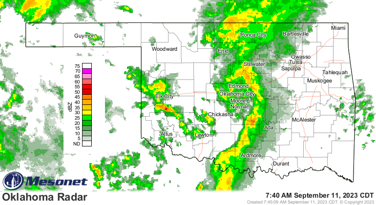
Heck, it's raining right now for crying out loud!
https://ticker.mesonet.org/archive/20230911/current-radar.png
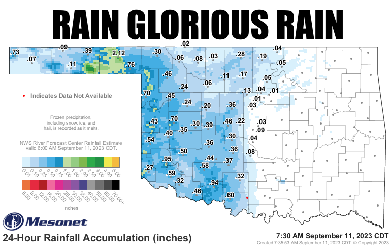
The heaviest rains, of course, have been in the eastern Panhandle, continuing
a streak we've seen since early summer.
https://ticker.mesonet.org/archive/20230911/rainrfc.24hr.png
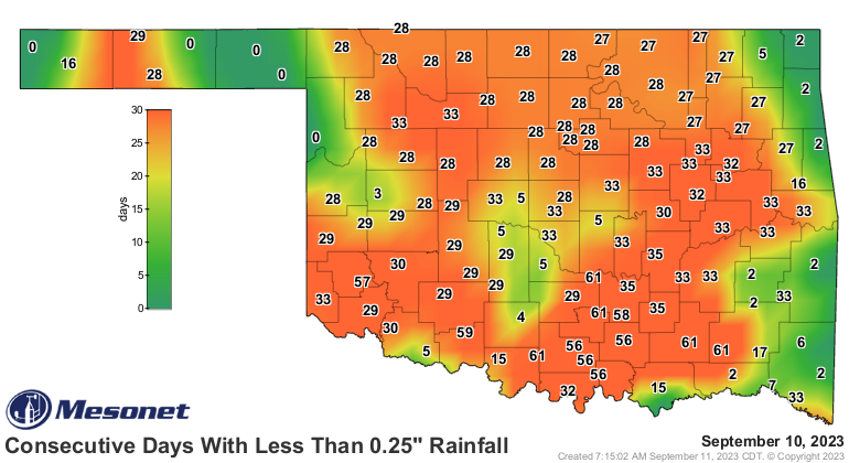
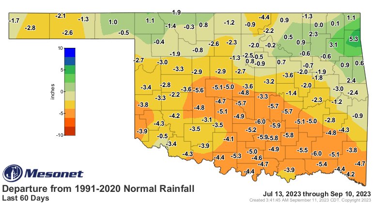
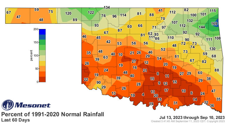
Speaking of streaks (so many ways to go there, but I'll avoid all), we should
see our 2-month-plus stretch of significant rain-less end today for much of
southern Oklahoma, which has been the driest such period in at least the past
100 years!
https://ticker.mesonet.org/archive/20230911/mesonet.rainfall.quarterinch.png
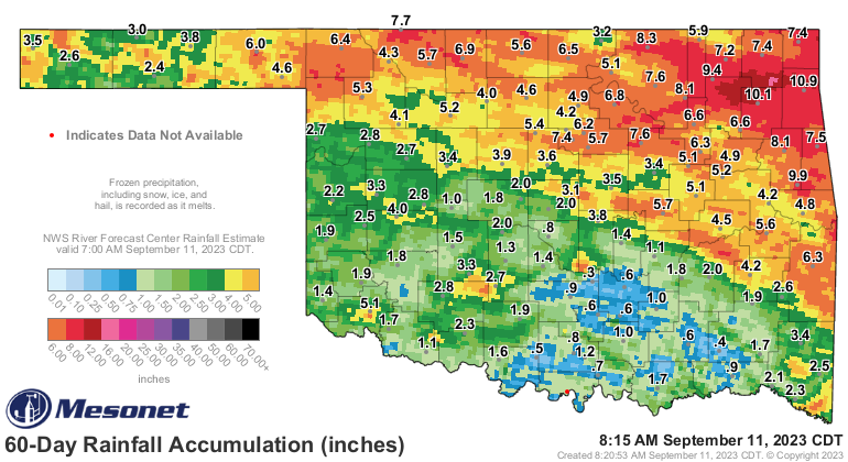
https://ticker.mesonet.org/archive/20230911/60day-rain-totals.png
https://ticker.mesonet.org/archive/20230911/del60day_rain.current.png
https://ticker.mesonet.org/archive/20230911/pct60day_rain.current.png
https://ticker.mesonet.org/archive/20230911/60day-stats.png
Unfortunately, it does appear that the north and east areas will see lower
totals. Remember, we're talking Oklahoma weather. Nothing can ever be that
easy. But everybody should get something, and that's better than nothing.
Just ask my scalp!
Gary McManus
State Climatologist
Oklahoma Mesonet
Oklahoma Climatological Survey
gmcmanus@mesonet.org
==================================================
The OCS/Mesonet Ticker
https://ticker.mesonet.org/
To subscribe or unsubscribe from the Ticker
or for questions about the Ticker or its content
Phone or Email the Ticker Manager at OCS
Phone: 405-325-2253 Email: ticker@mesonet.org
---------------------------------------------------
-C- Copyright 2024 Oklahoma Climatological Survey
===================================================
|


 Tweet
Tweet