MESONET TICKER ... MESONET TICKER ... MESONET TICKER ... MESONET TICKER ...
September 11, 2012 September 11, 2012 September 11, 2012 September 11, 2012
Potpourri
Cooler (and wetter!) weather on the way
Well, we have another cold front on the way that is supposed to cool us down
significantly Wednesday night into Thursday, and it looks like this one will
stick for awhile. No sign of greatly above normal temps for awhile after that.
Rain chances will also arrive with the front, and the latest 5-day forecast says
to expect an inch or so across parts of the state.
http://ticker.mesonet.org/archive/20120911/5-day-rain.gif
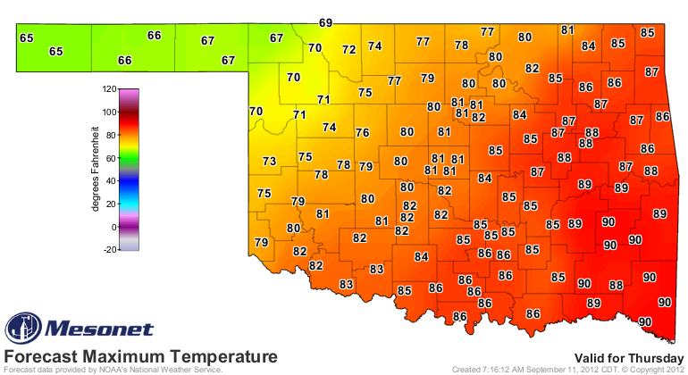
The temperatures are nice and autumnal later this week.
http://ticker.mesonet.org/archive/20120911/thursday-highs.png
http://ticker.mesonet.org/archive/20120911/friday-highs.png
http://ticker.mesonet.org/archive/20120911/saturday-lows.png
If those highs in the 60s actually occur on Thursday, that will be the first time
we've seen that on the Mesonet since June 1.
---------------------------------------------------------------------------------
Extreme fire danger
Unfortunately, with the drought still in place, we will have to get through some
fairly bad fire weather first in order to enjoy this front. Relative humidity
is dropping and the winds are picking up. A Red Flag Fire warning is in effect
for northern Oklahoma.
"...RED FLAG WARNING REMAINS IN EFFECT FROM NOON TODAY TO 8 PM CDT
THIS EVENING FOR NORTHERN OKLAHOMA...
* WIND...SOUTHERLY 20 TO 30 MPH...WITH GUSTS UP TO 40 MPH.
* HUMIDITY...MINIMUM RELATIVE HUMIDITY 12 TO 15 PERCENT.
* TEMPERATURE...HIGHS 93 TO 97 DEGREES.
* IMPACTS...ANY FIRES THAT DEVELOP WILL SPREAD RAPIDLY. A
STATEWIDE BURNING BAN CONTINUES FOR OKLAHOMA. REFRAIN FROM
ALL OUTDOOR ACTIVITY THAT COULD START WILDFIRES."
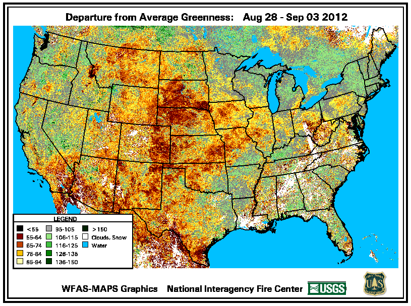
With all that less-than-green vegetation around, all that's needed is a spark.
http://ticker.mesonet.org/archive/20120911/departure-greenness.png
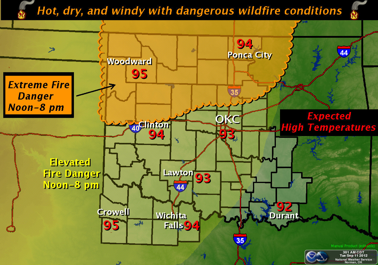
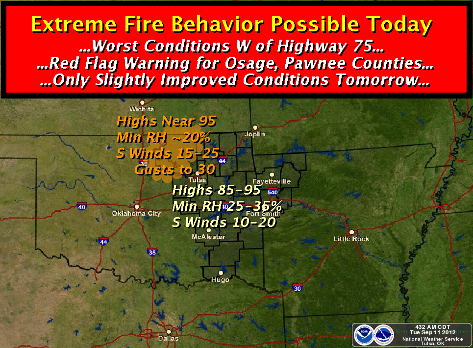
Our friends from the NWS are all on full alert today for wildfire danger.
http://ticker.mesonet.org/archive/20120911/amarillo-firedanger.jpg
http://ticker.mesonet.org/archive/20120911/norman-firedanger.jpg
http://ticker.mesonet.org/archive/20120911/tulsa-firedanger.png
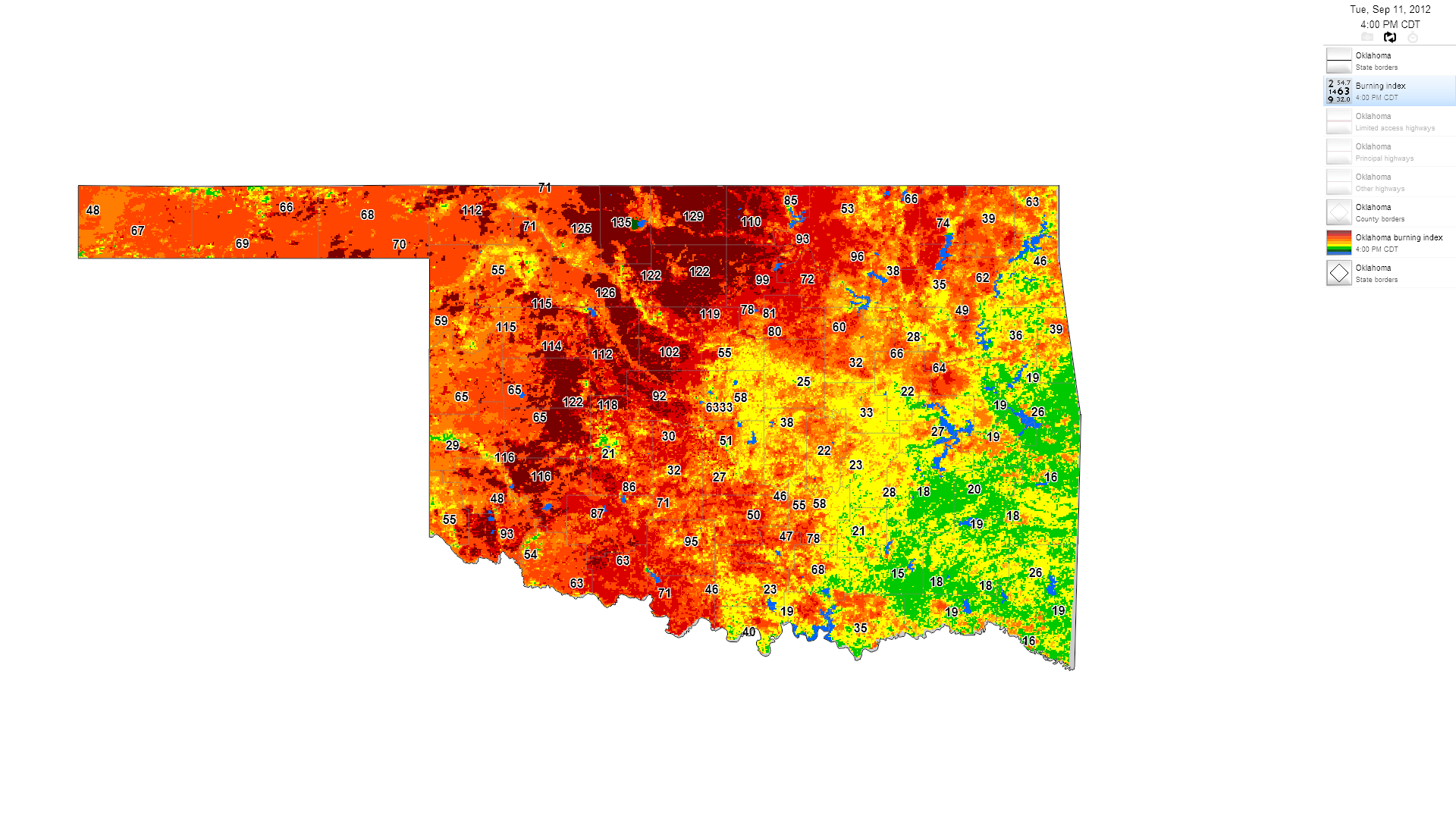
Fire danger will peak about 4pm according to the burning index forecasts on
the Mesonet's OK-FIRE website: http://okfire.mesonet.org
http://ticker.mesonet.org/archive/20120911/4pm-firedanger.png
-------------------------------------------------------------------------------
Warmest year still in our sights
I don't have to remind you just how warm it has been this year (and the last
couple of years). Oklahoma is still on pace to have its warmest year on record.
The official mark for January-August from NCDC now stands at 66.0 degrees,
easily the warmest first nine months of the year on record for the state.
Those records date back to 1895. The five warmest January-August periods are a
who's who of "it's frigging hot" periods in Oklahoma history, but also "I'm
sick and tired of this frigging drought" periods.
-****-
Year Jan-Aug Avg.
2012 66.0
2006 65.1
1954 64.7
2011 64.7
1934 64.5
-***-
Three months and change to go and 1954 is quaking in its boots. Here are the
three warmest years (Jan-Dec) on record.
-****-
Year Annual Avg.
1954 62.8
1998 62.0
1934 61.9
-***-
Not sure what 1998 is doing in there. We'll wait while it leaves.
(awkward pause)
2012 currently has about a 1.3F lead on 1954. September-December 1954 was
the fourth warmest such period on record, so it enjoyed a fairly warm last four
months of the year. 2012 will need above average temperatures the rest of the
way to eclipse 1954. If 2012 just has "normal" temperatures the rest of the
way, it will fall to second place at 62.5 degrees. September has done its job
thus far with a statewide average through Sep. 10 of 80.7 degrees. That's about
4.8 degrees above normal. Highs have been the culprit at 8.7 degrees above
normal while lows have only been about a degree above normal.
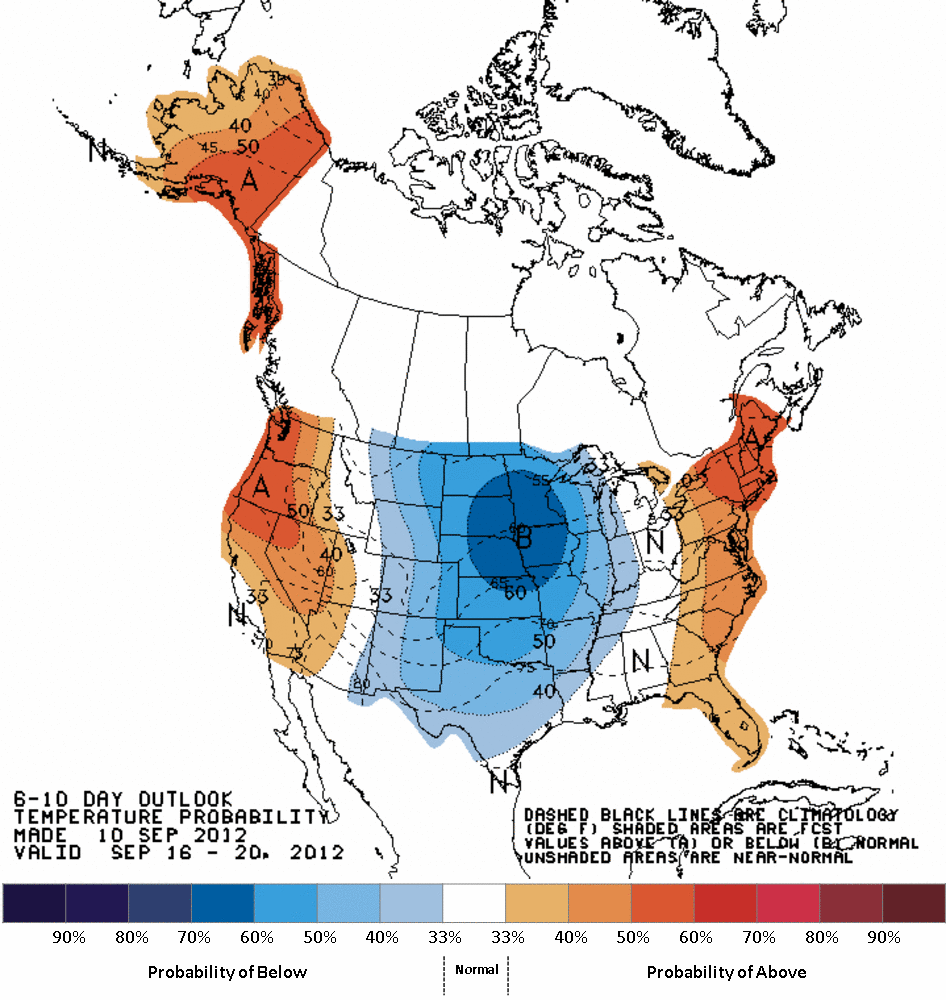
It's probably fortunate that September had such a big headstart since the
next couple of weeks might be on the cooler-than-normal side.
http://ticker.mesonet.org/archive/20120911/610temp.new.gif
http://ticker.mesonet.org/archive/20120911/814temp.new.gif
Who knows what October-December might bring. We might just have us a horse
race after all!
Gary McManus
Associate State Climatologist
Oklahoma Climatological Survey
(405) 325-2253
gmcmanus@mesonet.org
==================================================
The OCS/Mesonet Ticker
https://ticker.mesonet.org/
To subscribe or unsubscribe from the Ticker
or for questions about the Ticker or its content
Phone or Email the Ticker Manager at OCS
Phone: 405-325-2253 Email: ticker@mesonet.org
---------------------------------------------------
-C- Copyright 2024 Oklahoma Climatological Survey
===================================================
|


 Tweet
Tweet