Ticker for December 8, 2020
MESONET TICKER ... MESONET TICKER ... MESONET TICKER ... MESONET TICKER ...
December 8, 2020 December 8, 2020 December 8, 2020 December 8, 2020
I'm dreaming
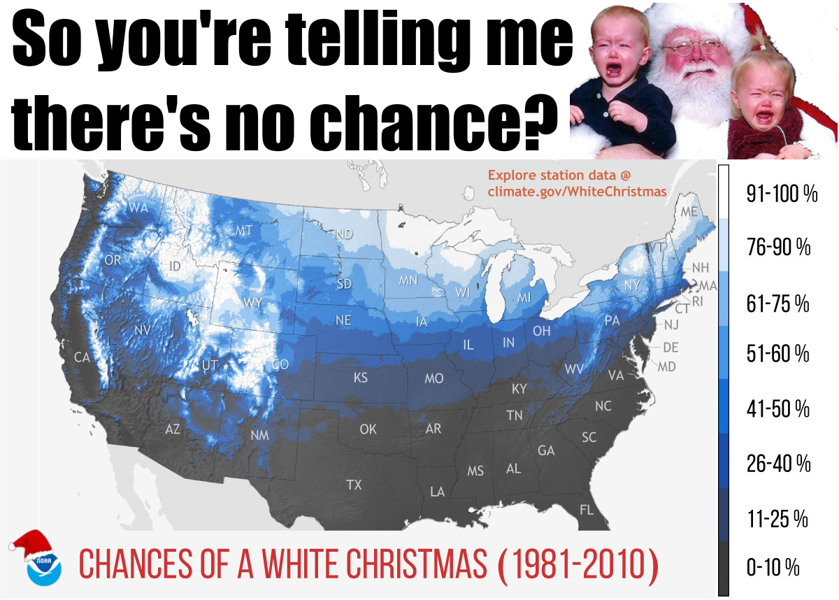
It's never too early to start thinking about a white Christmas, is it? Some folks
start thinking about it the day after Christmas. Let's be honest, though:
Oklahoma isn't the place to live if you want a near-guaranteed Christmas snow.
Northern Minnesota looks good, but who wants to live where summer lasts from
July 8th through July 8th? You could live on a mountain in Colorado, but you
better have Bezos-style cash these days. But, you live here so let's concentrate
on that quandary.
Obviously, northern Oklahoma is going to have a higher climatological chance of
snow on of at least an inch on the ground on Christmas Day. A couple of things
here -- the NOAA scientists that produced the map consider a white Christmas to
occur when there's at least an inch of snow on the ground on Christmas Day, and
the data used to produce the map were taken from the 1981-2010 normals. The
latter is important because we're a few months away from the new 1991-2020
normals, which should be more representative of our current climate.
And let's remember the most important caveat to this map...climatological chances
for a white Christmas start to become less important than the actual weather
patterns that are occurring as you get within a week or two of Christmas Day.
Gate, OK, in far eastern Beaver County has the greatest chance of a white
Christmas (I know, say "white Christmas" one more time!) at 18%. So a month
away, you can take that 18% and massage it when you look at the December
outlooks. The month looks warm and dry? Well, maybe the chance is a little less
than 18%. Then within a couple of weeks, you can look at the actual long-range
forecasts and see that the weather is tending towards a certain flavor the
up close to Christmas Day. Massage it again. Then when you get within a couple
of weeks, the climatological chances get thrown out the window and you just
go with what the weather patterns are showing. No storms showing up on the
long-range? Well, chances are starting to diminish? But wait, there's a storm
showing up on the 10-day output from the forecast models? Hmmm, maybe we go from
18% up to 25%? Then you keep massaging as you get closer and closer and the
forecast models start to coalesce on a single solution.
The climatological average starts out as the biggest factor farther out from
the event, but at some point climate and weather cross paths and weather starts
to take over and the climatological chances diminish to zero (and the weather
will then give you the actual chances). I think we're getting closer to the
point where climate and weather have crossed paths and we can just about start
looking towards the actual forecasts. Maybe not just yet, but we're close. Even
for places along the Red River that have a 0% climatological chance, like
Waurika, can have those odds tilted higher if the right weather system comes
along. The climatological average tells us that didn't happen very often (or
at all) from 1981-2010, however.
We can see from the CPC 8-14 day outlooks that the week leading up to Christmas
is tilted towards a warmer and drier than normal weather regime.
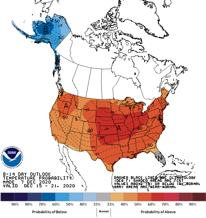
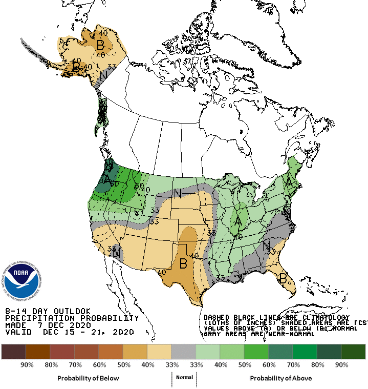
I'm not exactly devastated there, maybe just a bit concerned, for our white
Christmas chances. The fact they have portrayed nearly the entire country
as warmer than normal doesn't mean a big cold front isn't days away from
showing up in that time frame, but it would be nice to see a bit of blue on the
map up North. Maybe we can just placate that concern with the blue in Alaska?
And remember, these maps could look completely different when the new one
comes out this afternoon. Maybe they're tilted towards day 8 instead of day 14
as well.
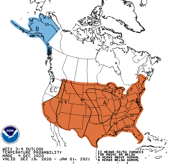
The 3-4 week outlooks (Dec. 19-Jan 1) aren't too encouraging either, but those
were produced last Friday, and these almost always show warmer and drier than
normal conditions from my anecdotally-influenced memory. Part of that is due to
the reliance on the 1981-2010 normals, which are probably going to end up
wetter and cooler than their 1991-2020 counterparts. So our "normal" weather
today is going to look more warm and dry compared to the weather from 10-30
years ago. We'll wait on the new normals to confirm that. At any rate, here
are what the 3-4 week outlooks look like.
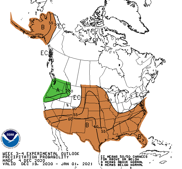
The long-range weather forecast models can get us up to right before Christmas.
I'm not going to dwell on what those say, because it's even beyond fantasycast
at that point. But, they don't look good. Don't mean nothing, and I said I
wouldn't dwell.
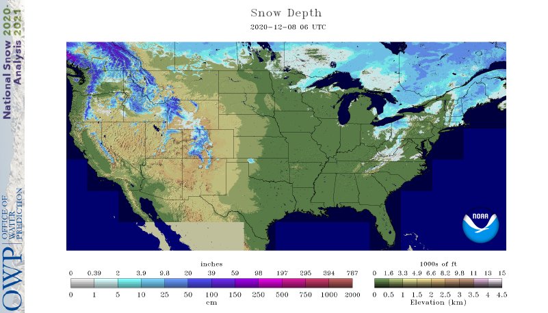
Just judging by what's on the ground TODAY, it's not looking good. Unless you
live in Harper County, I guess, but most of the country is without snow on the
ground at this point.
For more on the subject, check out this article on Climate.gov that goes into
much more detail. There's actually a handy-dandy interactive map on that page
where you can drill down to your favorite little town ($1 to Butch McCain) and
see your climatological average for a white Christmas.
https://www.climate.gov/news-features/featured-images/are-you-dreaming-white-christmas
In about a week or so, you can pretty much stop worrying about climatological
white Christmas chances and just start looking at the weather forecast.
Or, start loading up the U-Haul for northern Minnesota.
I'm dreaming (more like nightmare), of a brown, dusty Christmassss...
Gary McManus
State Climatologist
Oklahoma Mesonet
Oklahoma Climatological Survey
(405) 325-2253
gmcmanus@mesonet.org
December 8 in Mesonet History
| Record | Value | Station | Year |
|---|---|---|---|
| Maximum Temperature | 80°F | BURN | 2023 |
| Minimum Temperature | -15°F | KENT | 2005 |
| Maximum Rainfall | 2.35 inches | MTHE | 1994 |
Mesonet records begin in 1994.
Search by Date
If you're a bit off, don't worry, because just like horseshoes, “almost” counts on the Ticker website!