Ticker for October 8, 2020
MESONET TICKER ... MESONET TICKER ... MESONET TICKER ... MESONET TICKER ...
October 8, 2020 October 8, 2020 October 8, 2020 October 8, 2020
Eruption
2020, and that's all I have to say about that.
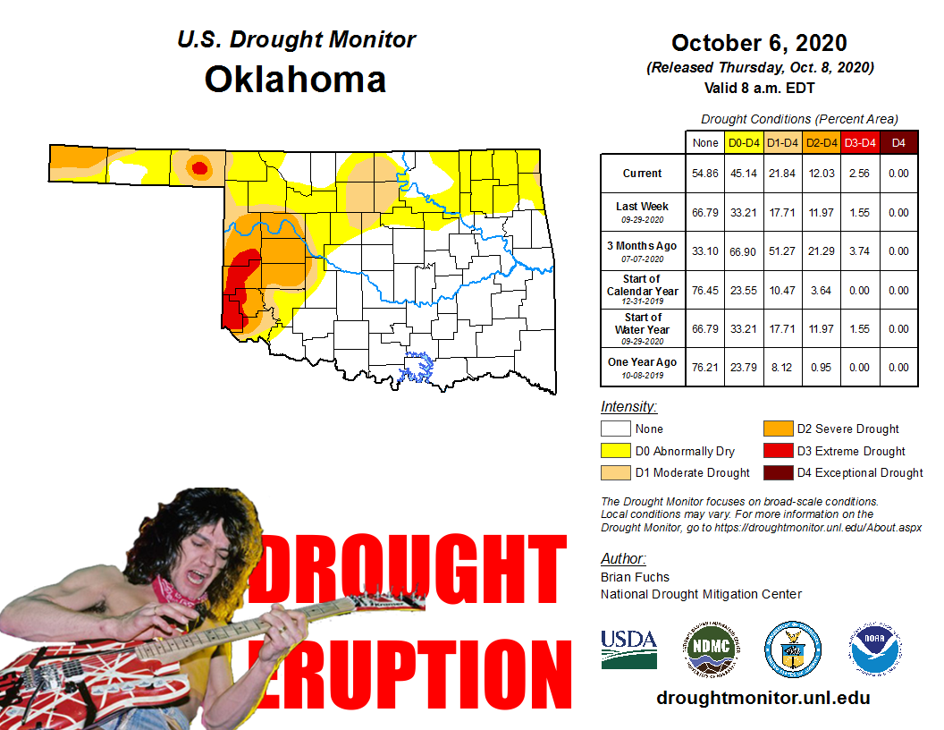
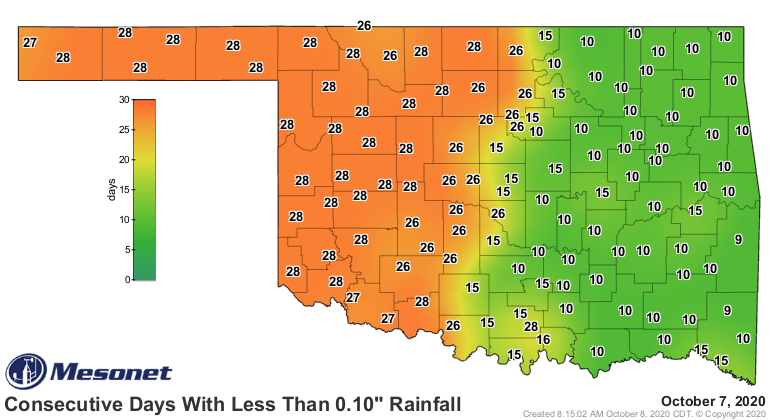
I wish there was better news on the drought front, but I'm not going to pull any
punches this time around. It's not too bad that the drought (at least D1)
increased by a little over 4%. I've been warning you about that for weeks. The
worse news is that the amount of Abnormally Dry (D0) increased dramatically as
well. The jump of D0-D4 was up about 12%, and those new yellow-colored areas are
definitely in imminent danger of sinking into drought (hence, "Eruption"). You can
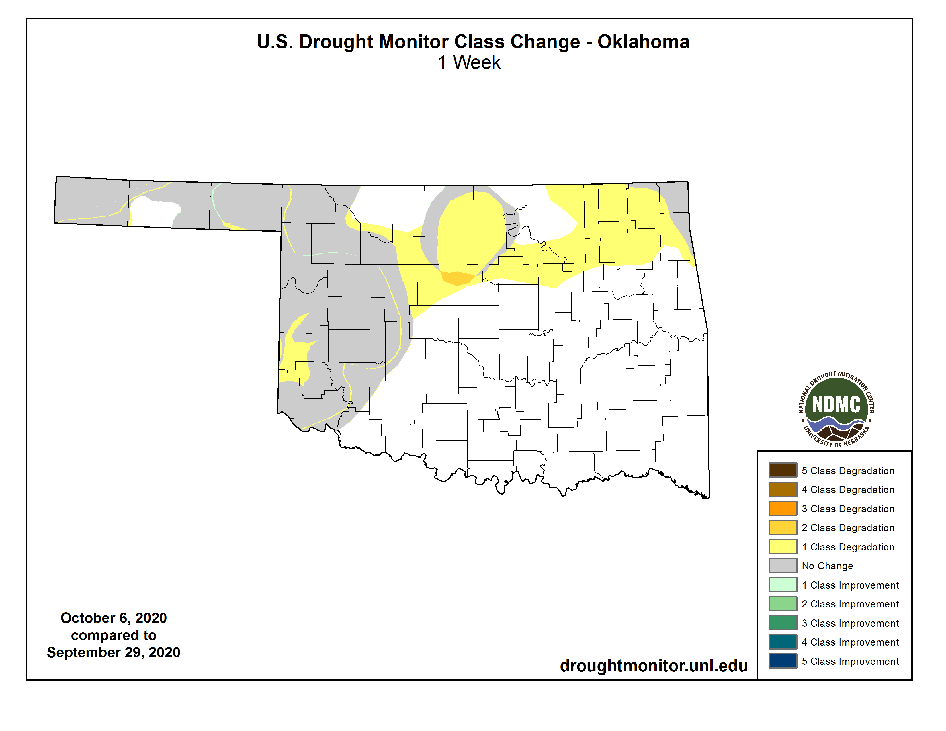
see the scope of the changes in the 1-week DM change map.
A lot of that new spread is based on the 30-60 day time frame. In just a few
days, the 30-day stats for much of western and northern Oklahoma are going to go
into record dry territory, unless there is something lower than Zero Point Zero.
Even now, the stats are getting into the bottom third of the record books.
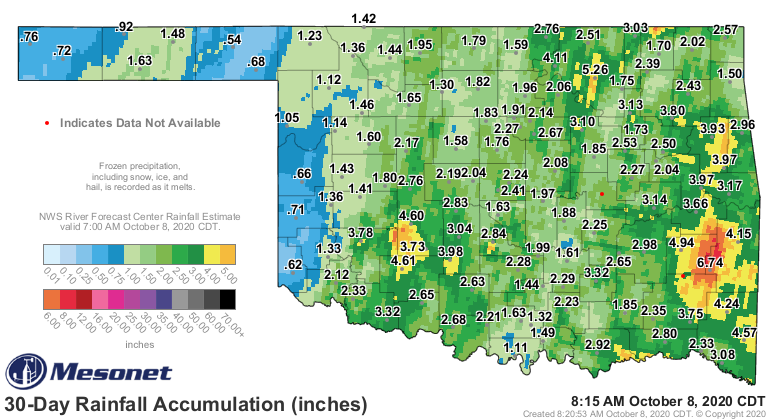
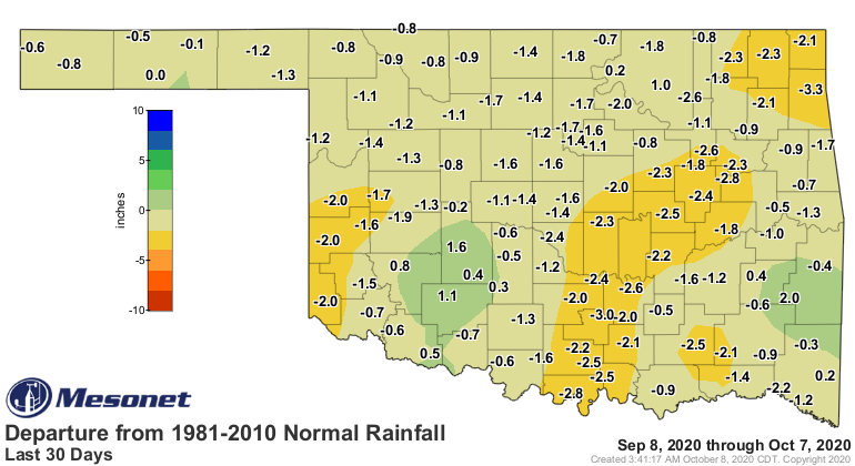
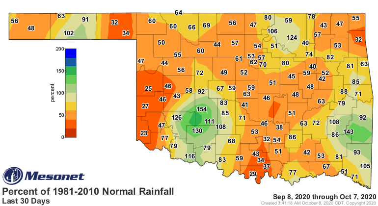
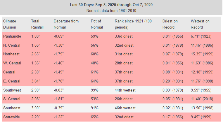
Again, give us a couple of days and that stat line is going to go a lot lower.
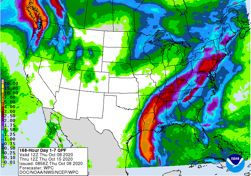
As we delve deeper into the drought, we see little relief in sight. Not saying
it will stay that way forever, but for the next week or two...probably so.
Who knows what impact our growing La Nina is having on this pattern. At most,
ENSO (El Nino/Southern Oscillation, which contains our friends El Nino and
Neutral Conditions, and our foe La Nina) is thought to have about a 30% guiding
hand in our weather. Lots of other things can contribute, like the MJO, the AMO,
the NAO, the AO, the PDO, the HBO, the SHOWTIME. It's putting all these
different teleconnections together to see how they interact that's important.
However, there still is no denying the guiding influence of ENSO, in this case
La Nina, on our past weather.
I've talked to you in the past about how the strength of a La Nina (or El Nino)
can be important. That's why we were given a bit of a pause when reading this
morning's CPC ENSO update. I'll quote here:
"It was the best of times, it was the worst of times."
Whoops, wrong update. Let's try again:
"A majority of the models in the IRI/CPC plume predict La Nina
(Niño-3.4 index less than -0.5°C) to persist through the Northern
Hemisphere winter 2020-21 and to weaken during the spring [Fig. 6].
The latest forecasts from several models, including the NCEP CFSv2,
suggest the likelihood of a moderate or even strong La Nina
(Niño-3.4 index values < -1.0°C) during the peak November-January
season. The forecaster consensus supports that view in light of
significant atmosphere-ocean coupling already in place."
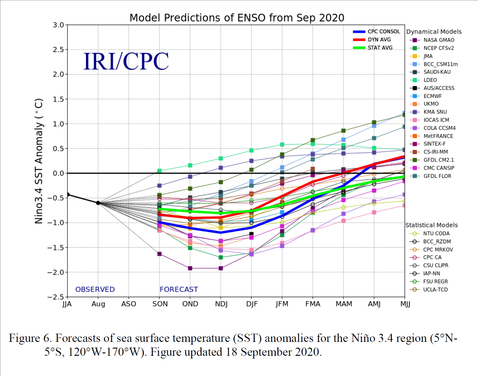
Yeah, there's a lot of jargon there, but the important phrase is "likelihood
of a moderate or even strong La Nina." That's what we didn't want to see. As
I showed you a few weeks ago, a moderate or strong La Nina (especially moderate)
give us a more negative outcome more frequently. The sample size is a bit
smaller for the moderate events, but the impacts are evident.
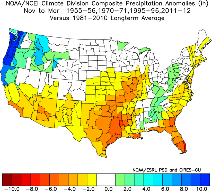
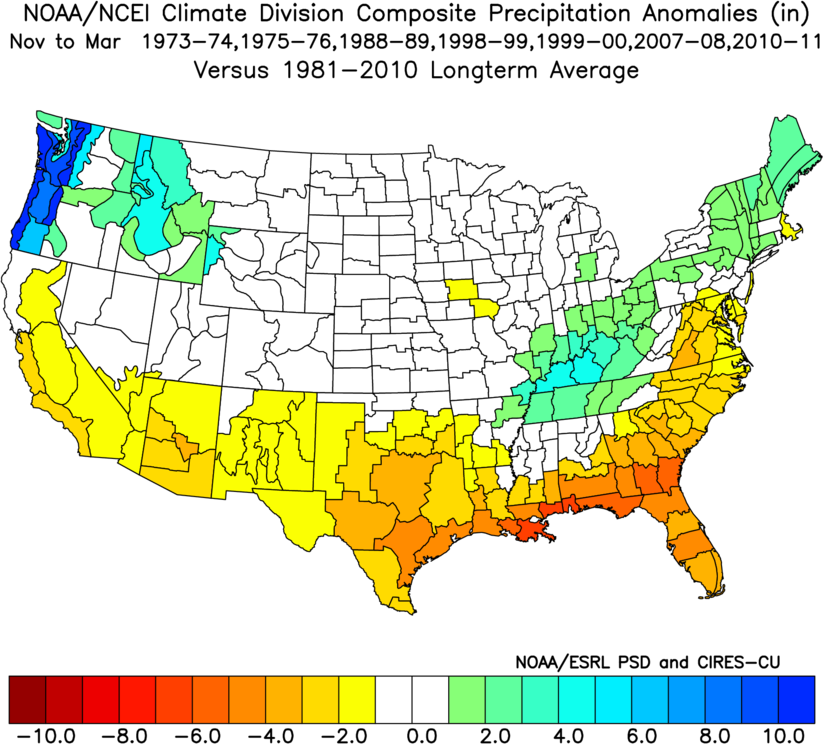
The last strong event we had needs no further elucidation, given that the drought
of 2010-11 is forever etched in our minds (that SUMMER! UGH!).
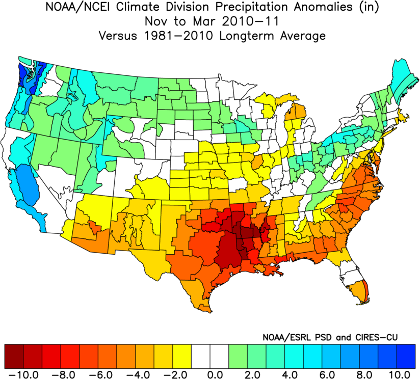
And remember, these maps are only showing the December-February period. If ONLY
the 2010-11 event had stopped there. La Nina's influence can last from fall
(like now) thorough early spring, with some momentum carrying those impacts
into late spring at times. Once you generate a drought through the fall into
winter, the driest time of the year, then you extend it into spring, the
pieces can fall into place to have a robust drought started entering the summer
months.
I don't believe we'll be faced with another 2010-11. That's worse than the
worst case scenario. A once in several generations type of event. Right now,
all we can say is that we have a drought building across the state, the
prospects for significant moisture look dim through the next couple of weeks,
and the odds will be tilted towards dry and warm weather for the next few
months thanks in part to La Nina, BUT CERTAINLY NOT GUARANTEED!
Extreme events can intervene in any larger climate pattern. Don't be too shocked
to see a massive snow, a massive rain, a large tornado outbreak, or any other
weather extreme, no matter how the weather is tilted in the broader sense. In
2011, we saw the state's all-time record cold temperature (-31 degrees, Nowata),
the all-time record 24-hour snowfall (27 inches, Spavinaw), the most April
tornadoes in history (50), and the largest hailstone (6 inches). And that
summer! Ugh!
To sum up...prepare for everything, but expect nothing?
Gary McManus
State Climatologist
Oklahoma Mesonet
Oklahoma Climatological Survey
(405) 325-2253
gmcmanus@mesonet.org
October 8 in Mesonet History
| Record | Value | Station | Year |
|---|---|---|---|
| Maximum Temperature | 100°F | GRA2 | 2021 |
| Minimum Temperature | 22°F | ELRE | 2000 |
| Maximum Rainfall | 5.94 inches | VINI | 2009 |
Mesonet records begin in 1994.
Search by Date
If you're a bit off, don't worry, because just like horseshoes, “almost” counts on the Ticker website!