MESONET TICKER ... MESONET TICKER ... MESONET TICKER ... MESONET TICKER ...
October 8, 2015 October 8, 2015 October 8, 2015 October 8, 2015
Drought expands, AGAIN!
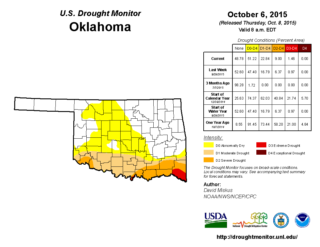
Never bury the lead. The new Drought Monitor map this morning pretty much says
it all, eh?
http://ticker.mesonet.org/archive/20151008/Oct6-drought.monitor.png
We now see the entire southern quarter of the state covered by moderate-extreme
drought...23% of the state, at least. McCurtain County continues to be the
epicenter of the Oklahoma portion of this flash drought episode, but that's part
of a bigger area to the south and east.
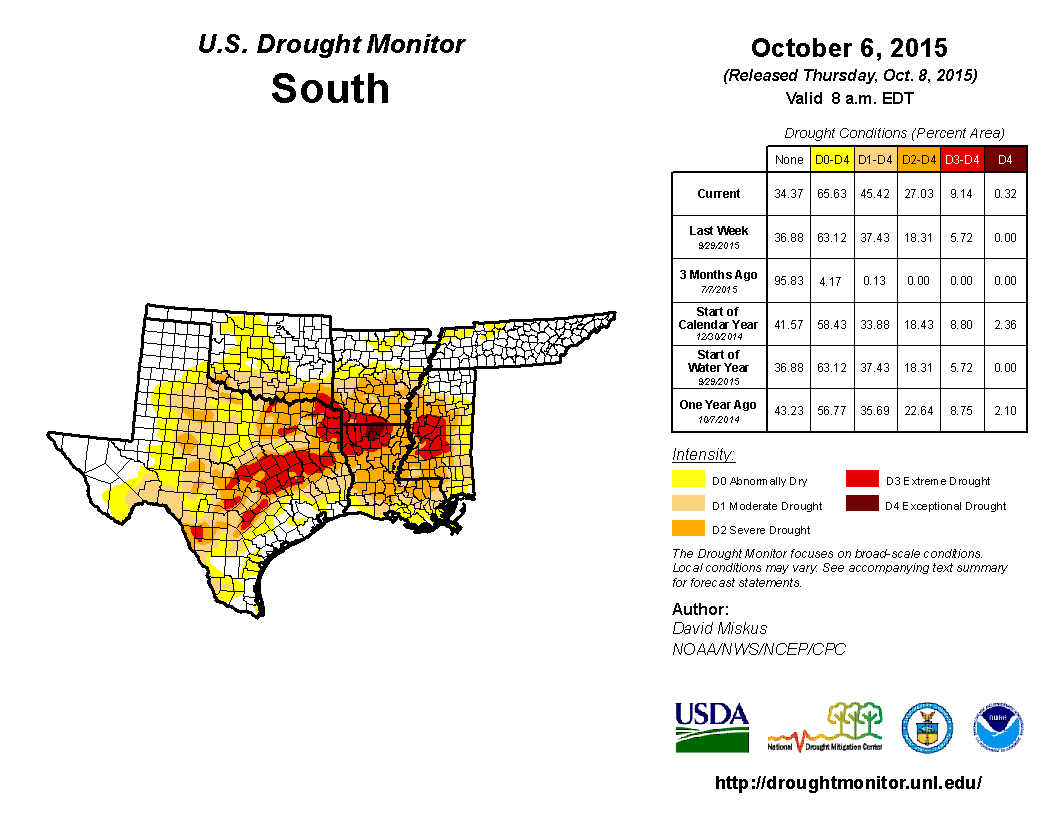
http://ticker.mesonet.org/archive/20151008/20151006_south_trd.png
All that extreme and exceptional drought in Texas, Arkansas and Louisiana tells us
had we not had our record-breaking rains of April-July, we'd be mired, MIRED I
SAY, in the same type of drought conditions we saw back in 2011-12.
Now I know some of you are asking yourselves "But Gary, how can we go from all
that rain and flooding and Ark building back in the spring to moderate-extreme
drought all over again?"
Well first off, unless your name is Gary, you might need to seek help. Secondly,
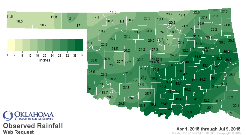
when this
http://ticker.mesonet.org/archive/20151008/april1-july9-stats.png
http://ticker.mesonet.org/archive/20151008/april1-july9-totals.png
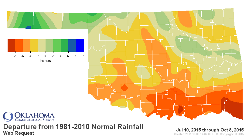
leads to this
http://ticker.mesonet.org/archive/20151008/july10-oct8-totals.png
http://ticker.mesonet.org/archive/20151008/july10-oct8-depart.png
http://ticker.mesonet.org/archive/20151008/july10-oct8-stats.png
in the middle of summer, in the presence of intense heat thanks to a persistent
heat dome, which also brings lots of water-evaporating sunshine, then yes,
a flash drought is almost a certainty, regardless of the antecedent conditions.
Southeast and South Central Oklahoma go from the wettest April 1-July 9 since
at least 1921 to the 3rd driest and 4th driest. Nearly the same length of time,
but unfortunately, there's a lot of summer between early July and mid-September.
So places like Idabel go from 26.9 inches in the previous period to 0.9 inches,
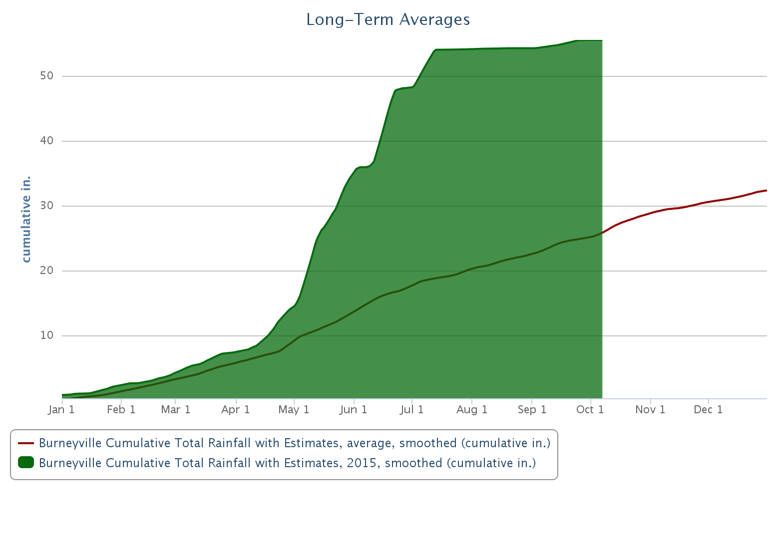
and Burneyville goes from 46.8 inches to 1.5 inches. Check out this graph of
the accumulated rainfall at Burneyville (green filled area) vs. the 2000-14
long-term Mesonet average.
http://ticker.mesonet.org/archive/20151008/burneyville-2015-rainfall.png
It is strange that they are about 23 inches above their normal annual total
at 55.5 inches with 3 months left to go, yet they are considered to be in
moderate-severe drought. And they're not the only ones. The OKC stations go
from 25-30 inches of rainfall from April through early July, then 2-3 inches
since. Woodward in NW Oklahoma, 18.9 inches to 4.2 inches. And finally, Altus,
our drought poster child throughout much of the 2010-15 drought, goes from
19.7 inches to 3.1 inches.
Okay, enough of how we got here. We know we're sliding back into "real" drought
thanks to this flash drought episode. But now that we're here, how are we gonna
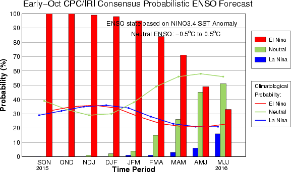
get back out of it? We know we have a very strong El Nino waiting for us later
in the fall through early spring of next year (which tends to bring us a wetter
than normal cool season).
http://ticker.mesonet.org/archive/20151008/ENSO-forecasts.gif
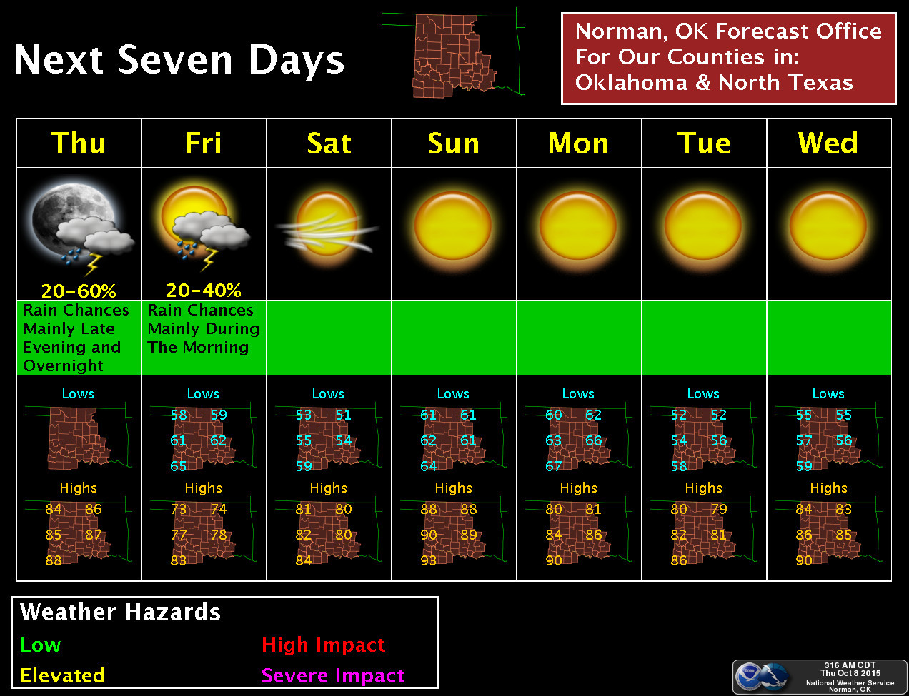
But for now, and the near-future, it looks like dry and unseasonably warm
conditions will dominate our weather.
http://ticker.mesonet.org/archive/20151008/7day-moisture-forecast.gif
http://ticker.mesonet.org/archive/20151008/nws-norman-7day-forecast.jpg
Sure, there will be a mild front or two in there, and a chance of moisture here
and there, but our next carefully placed bet for good rain comes past that point,
at least according to the latest outlooks. I wouldn't be betting the farm on
that one, however.
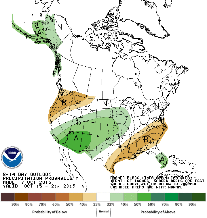
http://ticker.mesonet.org/archive/20151008/oct15-21-precip-outlook.gif
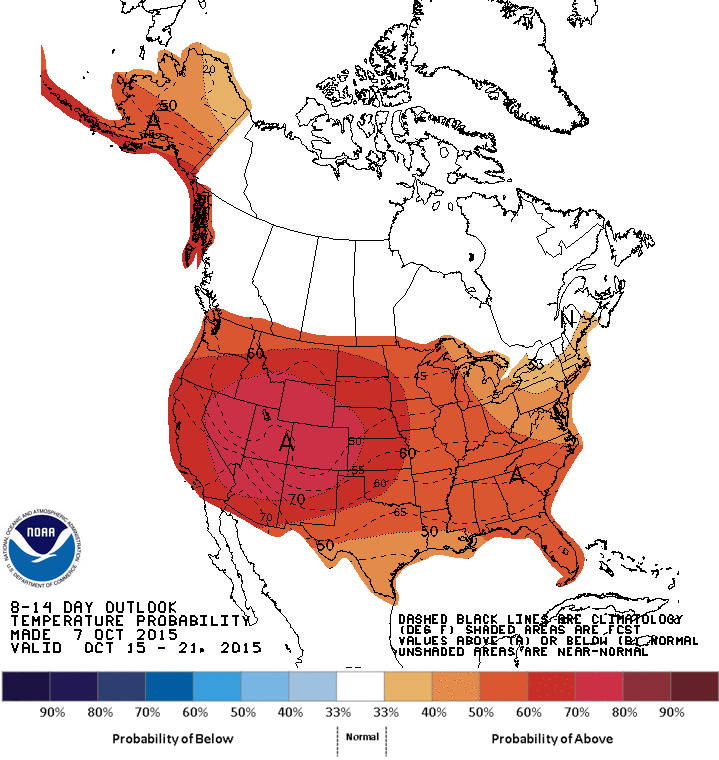
And there's no sign of one of those plunging arctic fronts just yet either.
http://ticker.mesonet.org/archive/20151008/oct15-21-temp-outlook.gif
That can all change in a hurry, but until then, the only changes you should
expect are more colors in the next Drought Monitor.
Gary McManus
State Climatologist
Oklahoma Mesonet
Oklahoma Climatological Survey
(405) 325-2253
gmcmanus@mesonet.org
==================================================
The OCS/Mesonet Ticker
https://ticker.mesonet.org/
To subscribe or unsubscribe from the Ticker
or for questions about the Ticker or its content
Phone or Email the Ticker Manager at OCS
Phone: 405-325-2253 Email: ticker@mesonet.org
---------------------------------------------------
-C- Copyright 2024 Oklahoma Climatological Survey
===================================================
|


 Tweet
Tweet