MESONET TICKER ... MESONET TICKER ... MESONET TICKER ... MESONET TICKER ...
September 8, 2020 September 8, 2020 September 8, 2020 September 8, 2020
Your experience may vary
http://ticker.mesonet.org/archive/20200908/4months-1day.png
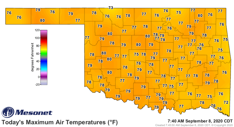
Well there you have it...the much ballyhooed and hyped cold front we've been
watching for more than a week is finally here. For northwestern Oklahoma, it's
liable to be historic. For central Oklahoma, it will be a nice cool down. For
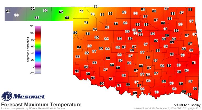
the southeast? SWING AND A MISS! Check out all the temperature forecasts for the
next few days (including tomorrow's forecast highs above, which serves as an
example of the different experiences we'll have with this front).
http://ticker.mesonet.org/archive/20200908/todays-forecast-highs.png
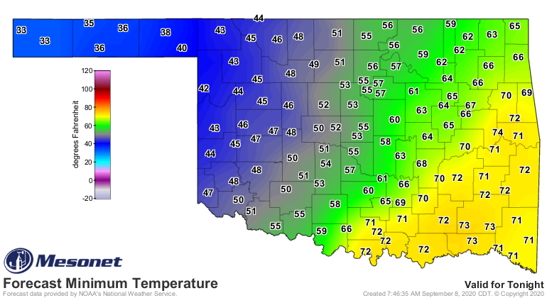
http://ticker.mesonet.org/archive/20200908/tonights-lows.png
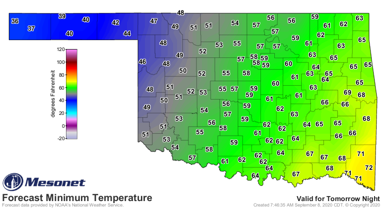
http://ticker.mesonet.org/archive/20200908/thursday-lows.png
http://ticker.mesonet.org/archive/20200908/thursday-forecast-highs.png
Southeastern Oklahoma never gets a taste, staying put in full
late-summer/early-fall mode with highs in the 80s and heat indices closing in on
triple-digits. Meanwhile, the I-44 corridor gets a whiff of the cool air, and
a boost from clouds and rain to *MAYBE* have a high in the 50s over the next
few days, but probably in the 60s. Then we start to see the real influence
of the coldest air that has plunged south as we get into the far northwest and
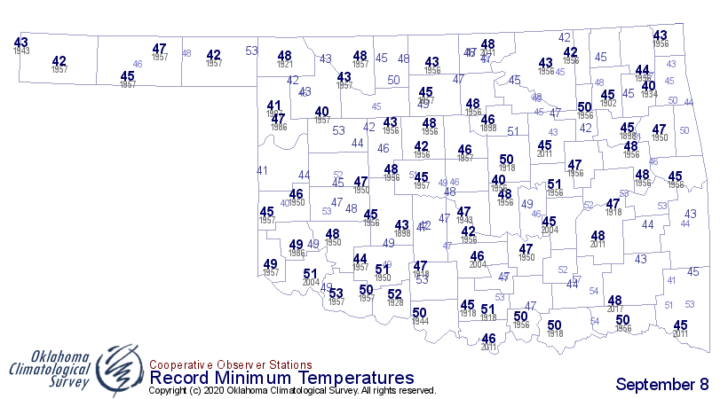
the Panhandle. That's the historic part. Check out the record low temperatures
for today across the state. If the western Panhandle can keep dropping, those
records might fall.
http://ticker.mesonet.org/archive/20200908/sept8-record-low-tmin.png
I think those records fall easily as the temperatures plummet into the 30s
by midnight. Has to be by midnight, which is also why we won't see record low
maximum temperature records fall, since the front waited until after midnight
to move in, cementing today's high temps in the 70s out that way.
http://ticker.mesonet.org/archive/20200908/todays-highs-thus-far.png
http://ticker.mesonet.org/archive/20200908/sept8-record-low-tmax.png
Then we start to look at tomorrow's lows. Right now, the NWS grids has the
low temperatures in the western Panhandle hovering close to freezing. That
would easily set the record low temperature in the state for September 8, which
is currently 40 degrees at several locations. Even if it just gets down to
33 or 34, that will be the lowest temperature ever recorded this early in the
season, beating Kenton's 35 degrees from Sept. 4, 1961.
But wait, there's more! What if somebody manages to drop to the 32 degrees
mark? Well, then we rewrite a more juicy record. The previous first freeze in
the state's history (well, pre-statehood included) came way WAY back on Sept.
13, 1902, at Fort Reno. Here is the actual volunteer observer form from back
in the day that has been digitized and put in the archives. Well, I would guess
the observer wasn't volunteering...he was probably in the army!
http://ticker.mesonet.org/archive/20200908/fort-reno-sept-1902.pdf
Should you doubt the observation, lots of spatial consistency that day, which
other stations dropping down to the lower 30s as well all across what was then
Oklahoma Territory and Indian Territory. So should some lucky station drop to
32 degrees or below (we're looking at you, Eva!), we'll shatter that record by
5 days. If not...oh well, probably still a record of some sort as explained
above.
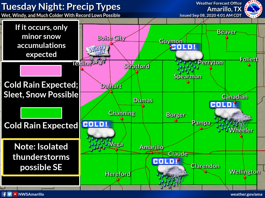
Now, big record possibility #2! How about the earliest snowfall on record for
the state? The NWS office in Amarillo is giving the western Panhandle at least
a decent chance of snow, trouble is it will likely be mixed with rain or sleet
(or the most dreaded of all winter snow forecast busts... it will all fall
as sleet).
http://ticker.mesonet.org/archive/20200908/nws-amarillo-snow.png
However, should they get an accumulation of at least a tenth of an inch of
snow, we'll have the earliest measurable snow in Oklahoma history. The previous
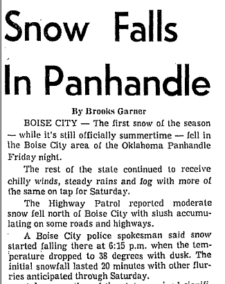
record early snow was from Sept. 17, 1971, in Kenton and Boise City. Kenton
*REPORTED* 3 inches on Sept. 18, 1971, but the snow began falling on September
17, as is evident from this Daily Oklahoman story from Saturday, Sept. 18. 1971.
http://ticker.mesonet.org/archive/20200908/dec17-snow-Oklahoman.png
So now we hope for at least a tenth of an inch somewhere. Come on Kenton, you
can do it!
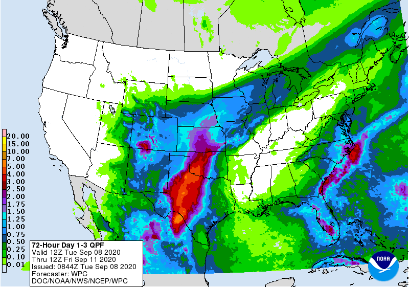
Even without the lack of snow and cold across the main body of the state, this
storm could still be a game-changer, at least for drought. Heavy rains could
inundate the drought-stricken areas across southwestern and west central
Oklahoma, FINALLY knocking that hazard down a peg or two after months of
growing deficits.
http://ticker.mesonet.org/archive/20200908/3day-rain-forecast.gif
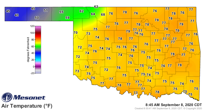
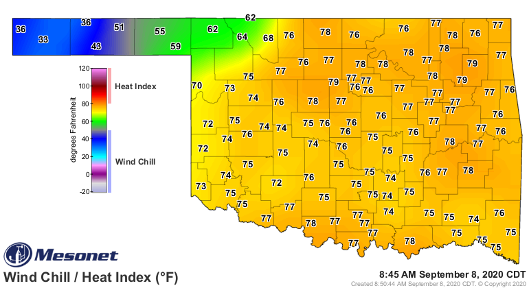
The front is currently through the far northwest, and just how far it moves to
the southeast will determine what month you get to experience later today
and tomorrow (for some, you get 4 months as the day goes on!).
http://ticker.mesonet.org/archive/20200908/current-temps.png
http://ticker.mesonet.org/archive/20200908/current-windchill.png
http://ticker.mesonet.org/archive/20200908/current-winds.png
The forecast models are very uncertain on how far southeast this thing will
move, so there's still hope you will either get some cold air if you want it,
or you won't if you don't...at least for those southeast of the I44 corridor.
Nothing to do now but sit back and watch, and prepare how best you see fit.
A t-shirt, light jacket, heavy jacket, winter coat, or parka.
Pick your month, and take your pick.
Gary McManus
State Climatologist
Oklahoma Mesonet
Oklahoma Climatological Survey
(405) 325-2253
gmcmanus@mesonet.org
==================================================
The OCS/Mesonet Ticker
https://ticker.mesonet.org/
To subscribe or unsubscribe from the Ticker
or for questions about the Ticker or its content
Phone or Email the Ticker Manager at OCS
Phone: 405-325-2253 Email: ticker@mesonet.org
---------------------------------------------------
-C- Copyright 2024 Oklahoma Climatological Survey
===================================================
|


 Tweet
Tweet