MESONET TICKER ... MESONET TICKER ... MESONET TICKER ... MESONET TICKER ...
December 7, 2016 December 7, 2016 December 7, 2016 December 7, 2016
How does 38000 BTUs sound about now?
http://ticker.mesonet.org/archive/20161207/NWC-Space-Heater-Meter.png
The National Weather Center is famous for many things, of course. It arguably has
the world's greatest collection of scientific minds concerned with severe weather
research (and experience). It's one of the top radar innovation labs in the
world. It houses the best (THE GOLD STANDARD) mesoscale weather observation
network in the world in the Oklahoma Mesonet. It's home to the most handsome
Oklahoma state climatologist (okay, there's only one, so I hold the most
ugly title too). And...it's so drafty that even George Bailey would pack his
bags and leave. On a cold, windy day, you'd better have a space heater handy!
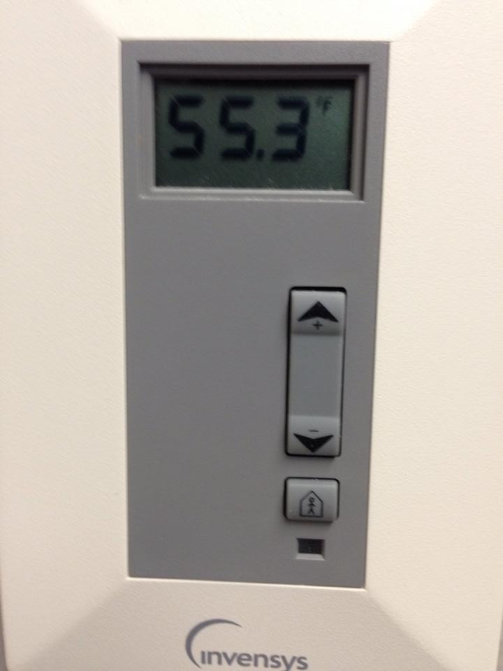
For example, here's my office thermostat from Nov. 12, 2014, and the wind
chills that day.
http://ticker.mesonet.org/archive/20161207/garys-thermostat.jpg
http://ticker.mesonet.org/archive/20161207/nov12-2014-windchill.png
That's a Level 3 NWC SPACE HEATER METER alert right there! And tomorrow morning,
after that cold front with its frigid weather and strong winds has pushed
through the state, I'm betting I'll have my space heater fired up.
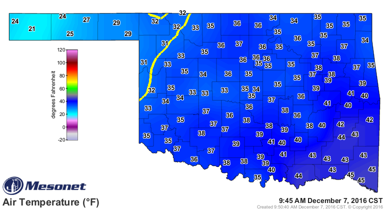
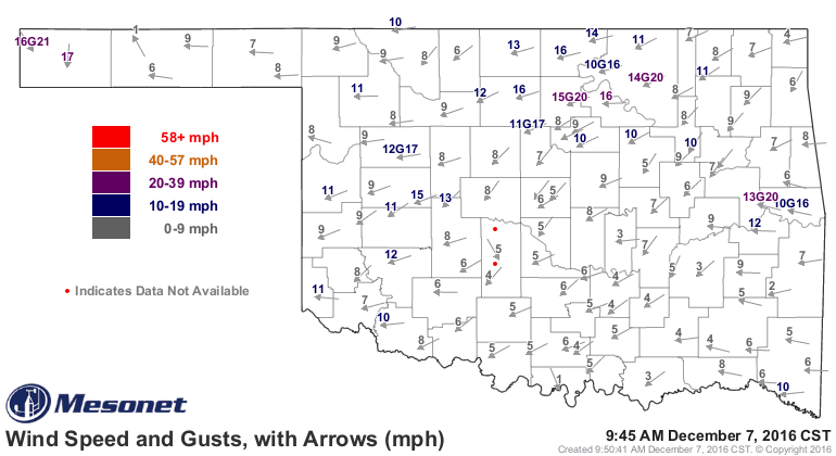
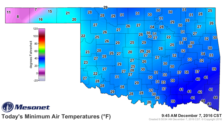
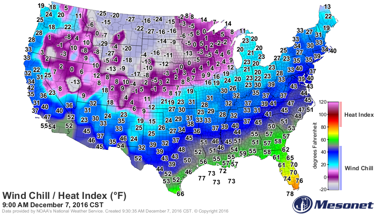
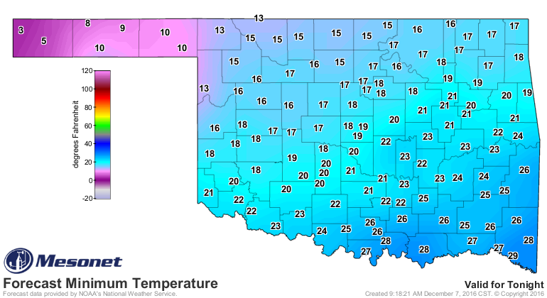
The cold front has just intruded upon the western Panhandle and it's headed this
way. Here's a flurry of Mesonet maps showing you where the front is, and just
how cold it is behind it.
http://ticker.mesonet.org/archive/20161207/current-temps.png
http://ticker.mesonet.org/archive/20161207/current.gustarrows.gif
http://ticker.mesonet.org/archive/20161207/current-windchills.png
http://ticker.mesonet.org/archive/20161207/todays-low-temps.png
Windchills in the single digits already. Ugh, can't wait for it to get here!
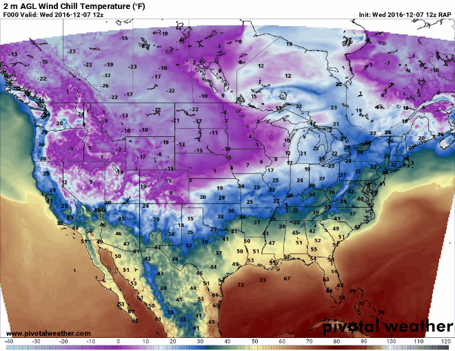
And there is indeed worse behind it!
http://ticker.mesonet.org/archive/20161207/be-afraid.png
Today/tonight (depending on where you are) will be bad, tomorrow morning will
be worse! Here's an animated windchill forecast map showing you how that big
glob of frigid, windy air is held back for just a bit today but eventually
overwhelms the entire region over the next 21 hours.
http://ticker.mesonet.org/archive/20161207/21hour-forecast-loop.gif
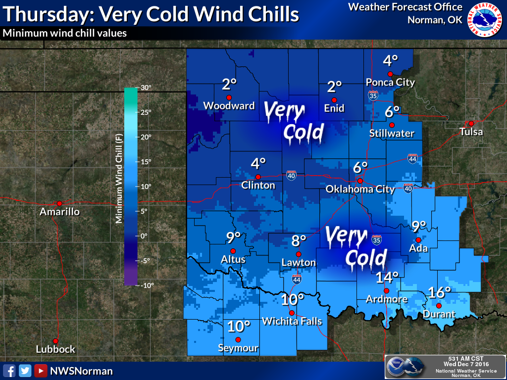
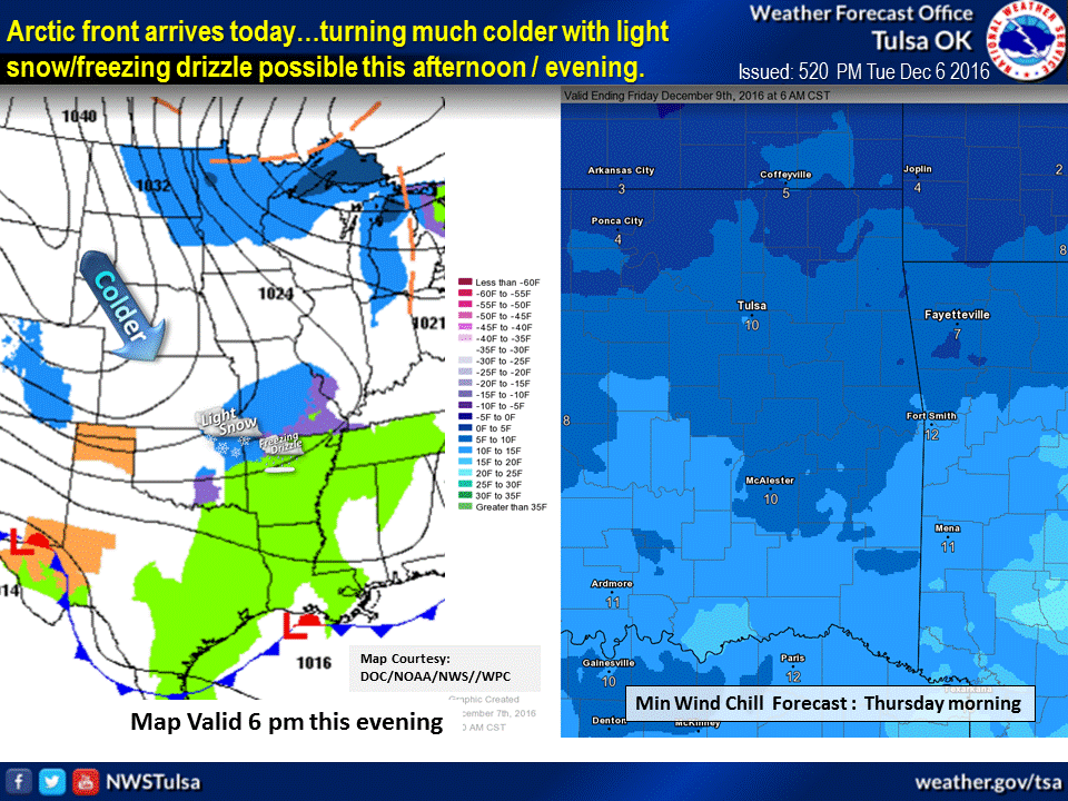
And here's the ugly truth from the Norman and Tulsa NWS offices.
http://ticker.mesonet.org/archive/20161207/nws-norman-thur-windchill.png
http://ticker.mesonet.org/archive/20161207/nws-tulsa-windchills.gif
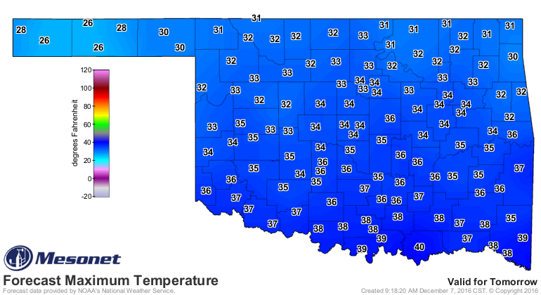
And to heck with the wind, the actual air temps aren't going to be a picnic
either.
http://ticker.mesonet.org/archive/20161207/thursday-lows.png
http://ticker.mesonet.org/archive/20161207/thursday-highs.png
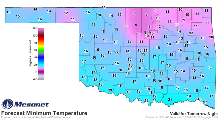
http://ticker.mesonet.org/archive/20161207/friday-lows.png
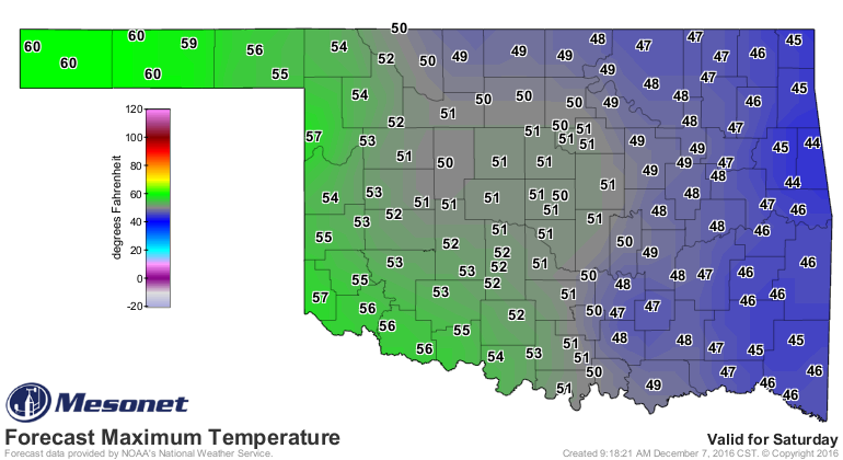
The good news is this will be a short-lived arctic air outbreak, and it will
start to slide off to the east by the early weekend. Look at the recovery in
western Oklahoma on Saturday.
http://ticker.mesonet.org/archive/20161207/saturday-highs.png
So hunker down, stay out of the wind, fire up those space heaters if you have
to. Here's your official unofficial statewide NWC Space Heater Meter for
the next couple of days.
http://ticker.mesonet.org/archive/20161207/OK-NWC-Space-Heater-Meter.png
38,000 BTUs sound pretty good right about now.
Gary McManus
State Climatologist
Oklahoma Mesonet
Oklahoma Climatological Survey
(405) 325-2253
gmcmanus@mesonet.org
==================================================
The OCS/Mesonet Ticker
https://ticker.mesonet.org/
To subscribe or unsubscribe from the Ticker
or for questions about the Ticker or its content
Phone or Email the Ticker Manager at OCS
Phone: 405-325-2253 Email: ticker@mesonet.org
---------------------------------------------------
-C- Copyright 2024 Oklahoma Climatological Survey
===================================================
|


 Tweet
Tweet